
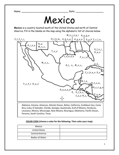
Mexico is located south of the United States and north of Central America. Introduce your learners to Mexico and surrounding with this printable map activity! Two worksheets (plus answer key).
Page 1:
FILL IN THE BLANKS on the map for each of the following: Alabama, Arizona, Arkansas, Atlantic Ocean, Belize, California, Caribbean Sea, Costa Rica, Cuba, El Salvador, Florida, Georgia, Guatemala, Gulf of Mexico, Honduras, Louisiana, Mexico, Mississippi, New Mexico, Nicaragua, Oklahoma, Pacific Ocean, Panama, South Carolina, Texas.
COLOR CODE: Choose a color for the United States, Mexico, Central America, and Bodies of Water. Then color the map.
Page 2: Use your completed map and compass to answer 7 questions.
Page 3: Answer Key.
Colored pencils and a pen or pencil are needed for this activity. No other prep needed.
Thank you so much for using my printables with your learners! I hope you find them useful. Reviews are welcome and very much appreciated. Please browse this store for more worksheets to introduce your learners to the countries of the world!
Something went wrong, please try again later.
This resource hasn't been reviewed yet
To ensure quality for our reviews, only customers who have purchased this resource can review it
Report this resourceto let us know if it violates our terms and conditions.
Our customer service team will review your report and will be in touch.
$1.50