

This is a powerpoint which was originally used as 2 summer school sessions for years 5&6. It would be fine for KS2-3 between years 5 & 8, but ideally as an introduction to continents. The first session allows pupils to use the information sheets provided to decorate a continent with physical features (such as waterfalls, mountains, forests etc.). The second session looks at how humans live across the different continents of the world and asks pupils to focus on one area and create a person from that country and then create a display where the people are labelled onto the physical geography world map.
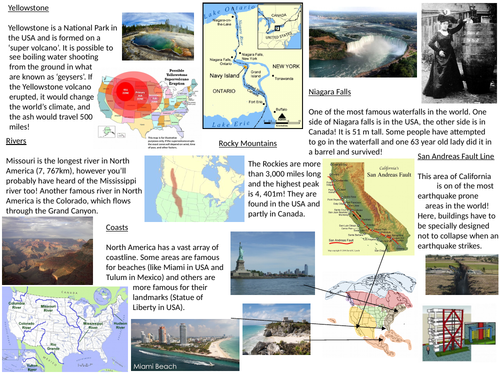
The continent maps are to be printed on A3. If possible, try and print the Asia continent larger so it fits better, but I know this isn’t always possible- I did mine all on A3.
The 2 sessions are based on allowing 1 hour for each, but between 1 hour and an hour and a half for each session should work well.
I also photocopied some pages to go with the handouts. A favourite book of mine is ‘Children Just Like Me’ by Unicef. Unfortunately I can’t scan these in for copyright reasons, but there’s loads of information in the handouts. These are just really an added bonus.
Something went wrong, please try again later.
This resource hasn't been reviewed yet
To ensure quality for our reviews, only customers who have purchased this resource can review it
Report this resourceto let us know if it violates our terms and conditions.
Our customer service team will review your report and will be in touch.
£4.00