Mountain Environments is a Geography unit suitable for KS2 (Y4-6) and has everything you need for covering a mountains topic.
The planning overview, topic title page and vocabulary page can be downloaded for free here. Lessons include:
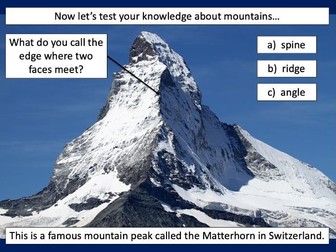
L1 – Identifying the key features of mountains
L2 – Identifying the world’s major mountain ranges
L3 – Locating the world’s famous mountains using latitude and longitude
L4 – Understanding how fold mountains are formed
L5 – Investigating the structure of a volcano (FREE)
L6 – Researching famous world mountains (FREE)
L7 – Investigating mountain climates
Each lesson includes a presentation and differentiated activities/worksheets.
If you like this resource, we would appreciate a review! We will happily send you a free resource in return for a review or useful suggestions/feedback. Contact us at ed@teachitforward.co.uk.
This is the first lesson in Mountain Environments, a Geography unit designed for students in upper KS2 (Y4-6).
First the presentation introduces students to the topic and looks at some of the activities people do in mountains. It then introduces the key features of a mountain range.
The activity challenges students to identify the key features of a mountain environment. It is differentiated three ways:
Easier – Students identify 8 key features of mountains.
Medium – Students identify 10 key features of mountains.
Harder – Students label the key features of mountains in their exercise book.
Extension – Students match mountain vocabulary to their definitions.
If you like this resource, we would appreciate a review! We will happily send you a free resource in return for a review or useful suggestions/feedback. Contact us at ed@teachitforward.co.uk.
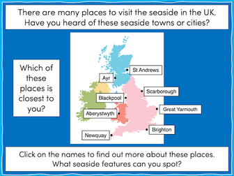
This lesson is part of The Seaside, a Geography unit designed for students in KS1 and lower KS2, but can also be taught as a stand alone lesson.
The presentation takes students on a tour of eight seaside towns and cities around the United Kingdom including: Ayr and St Andrews in Scotland; Aberystwyth in Wales; Blackpool and Newquay in England.
The activity then challenges students to use their map skills to locate these towns and cities on a map of the UK. This can be done using an atlas or the prompt maps included.
Easier - Students label 8 seaside towns and cities using a prompt map.
Medium - Students label 12 seaside towns and cities using a prompt map.
Harder - Students label 12 seaside towns and cities using an atlas.
Extension - Students locate and label 2 further seaside towns and cities from each country of the UK.
If you like this resource, we would appreciate a review! We will happily send you a free resource in return for a review or useful suggestions/feedback. Contact us at ed@teachitforward.co.uk.
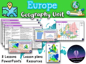
This Europe Geography Unit is a comprehensive and engaging teaching resource designed for Key Stage 2 children to explore various aspects of Europe, including famous landmarks, cultural similarities and differences, and the impact of human activity on the environment. The unit consists of eight lessons, each targeting specific learning objectives and accompanied by a range of interactive activities and discussions.
Lesson 1: Introduction to Europe
In this lesson, students are introduced to the continent of Europe and its diverse countries. They learn about the significance of Europe, its geographical features, and the countries that make up the continent.
Lesson 2: Exploring European Landmarks
Students delve into the fascinating world of famous landmarks in Europe, such as the Eiffel Tower, Colosseum, Big Ben, and more. They learn about the historical and cultural importance of these landmarks, their locations on a map of Europe, and engage in activities like landmark descriptions and map marking.
Lesson 3: Cultural Similarities and Differences
This lesson focuses on the cultural aspects of different European countries and compares them to the students’ local area. Students learn about traditions, customs, and languages, and engage in activities like creating travel brochure collages and group discussions about dream European holidays.
Lesson 4: Trade and Travel Connections
Students explore the trade and travel connections between Europe and their local area. They analyze import and export of goods, tourism, and transportation networks, and evaluate the impact of geographical factors on these connections.
Lesson 5: Planning a European Travel Adventure
In this lesson, students plan an imaginary travel adventure to visit multiple European landmarks. They research the landmarks, their locations, and plan an itinerary, considering factors like transportation, accommodations, local cuisine, and cultural experiences.
Lesson 6: Expressing Personal Views about European Locations
Students learn to express their opinions and preferences about specific European locations, providing clear reasons for their views. They engage in discussions and debates, considering factors like climate, landmarks, culture, or personal interests.
Lesson 7: Geographical Similarities and Differences
This lesson focuses on understanding geographical similarities and differences between Spain and the students’ local area. Students explore traditions, customs, languages, and analyze trade and travel connections, considering the impact of geographical factors.
Lesson 8: Graphing and Comparing Geographical Data
Students gather and analyze data related to temperature and rainfall in specific European locations. They create graphs to represent the data accurately and compare and interpret the data to draw conclusions about environmental conditions.
This resource provides a comprehensive and well-structured unit for teaching outstanding geography lessons about Europe to Key Stage 2 children. It incorporates a variety of interactive activities, discussions, and opportunities for reflection, promoting critical thinking and global awareness among students. The lessons are designed to engage and inspire students while fostering their understanding of landmarks and cultures. Also suitable for Key Stage 3.
KS2 LKS2 UKS2 KS3
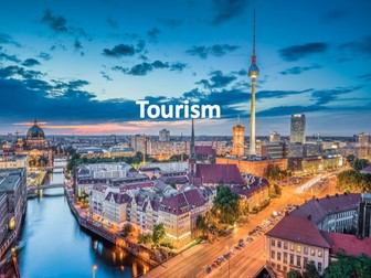
Full unit of work for tourism. All lesson are suitable for 50 minutes to 1 hour of teaching time. Includes supporting worksheets for lessons - no additional resources are required. Homework’s integrated into lessons where appropriate.
Most suitable for KS3 geography.
All lessons have a starter and lesson objectives. All PowerPoints in the same style.
Lesson sequence:
1 - What is tourism?
2 - The growth of tourism
3 - What attracts tourists to different destination?
4 - British tourism
5 - What are the impacts of tourism in National Parks?
6 - Declining tourism in Britain
7 - History and tourism
8 - The impact of tourism
9 - Jobs in the tourist industry
10 - Ski resorts
11 - Tourism in Kenya
12 - Sustainable tourism
13 - Sustainable tourism in Peru
14 - Does tourism cause conflict?
For more resources visit This is Geography. Full SoW for all new GCSE specifications - AQA, Edexcel, OCR, CIE IGCSE, Edexcel IGCSE and Eduqas. As well as over 200 lessons for KS3 and KS2. Want something bespoke designing? Email us for further details info@thisisgeography.co.uk
Have any issues with this resource or a request? Contact us directly for the quickest response at: explore_education@outlook.com
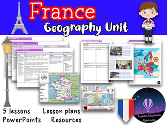
This brilliant unit has five detailed lessons that will help your class learn all about France and it’s physical and human geography.
This can be used flexibly over a half term and covers a range of topics, including:
Map work
Life in France (schools, food and routines)
Sheffield v Paris (can be adapted to any English locality)
Napoleon
Famous French people
Each lesson has a detailed lesson plan, PowerPoint and accompanying resources.
Resources include:
x5 lesson plans
Blank map of Europe
Labelled map of Europe
Blank map of France
Information sheet - French food and drink
Information sheet - French schools
Information sheet - Interview with a British family
School life comparison table worksheet
Information sheet - Paris
Information sheet - Sheffield
Editable worksheet - comparing Paris and Sheffield (PDF also included)
Newspaper template
Storyboard template
Wanted poster template
French history timeline worksheet
French history timeline answers
Names of famous French people to research
Website links to research
Lesson 1: L.O: to know the location of countries in Europe, including France, and to be able to plot human and physical features onto a map.
Success Criteria:
I know where the UK, France, Germany,
Italy and Russia are located in Europe.
I can use the points of the compass to help me to plot human and physical features onto a map.
Lesson 2: L.O: to understand life in France and the differences and similarities to life in the UK
Success Criteria:
I know what a typical school day is like in France.
I know a French person’s typical diet
I can compare life in France to my life in the UK and say what is similar and what is different.
Lesson 3:L.O: to compare the physical and human geography of Paris and Sheffield (or any city near you!)
Success Criteria:
I can locate Paris on a map of France
I can locate Sheffield on a map of the UK
I can compare their physical geography
I can compare their human geography
Lesson 4:L.O: to know the history of France around the time of Napoleon Bonaparte and understand how Napoleon changed Europe.
Success Criteria:
I can make notes using bullet points
I can use a time line to show important events
I can include some of the events and dates in my work.
Lesson 5:L.O: to use the internet to find and present facts.
Success Criteria:
I know some famous French people
I can say why they are famous
I can use Google to find websites with key facts including date of birth, why they were famous and death (if applicable)
I can present these facts as a slide from a PowerPoint
Graded Outstanding by leaders.
UPDATED - 21/12/19 Lesson 3 PowerPoint reuploaded - all errors now cleared.
UPDATED - 16/01/21
UPDATED - 02/02/22 All resources, PowerPoints and lesson plans upgraded
geography history europe ks2 year 3 year 4 year 5 year 6 y3 y4 y5 y6 lks2 uks2
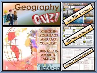
Over 10 rounds and 70+ Questions. Geography Quiz. Geography Quiz - General Knowledge A fun knowledge quiz that tests a range of different skills with students working in teams to compete against each other. Let the best team win!
This resource contains:
☞ 1x PowerPoint with questions and answers laid out in professional format
☞ 1x Student Answer Sheet double sided out of /70+ Marks (PDF and PPT Version) and all the answers!!
☞ Contains 10 Rounds: Name the Tourist Attraction, What Country Am I?, True or False, Identify the Flag, Anagrams, Match the Capital to the Country, Design Challenge and more…
✿ This quiz resource is perfect for lesson time, form time, extra curricular clubs, part of a drop down day or as a fun and educational treat for your class.
✿ A variety of different rounds and different challenges within this quiz for all types of learners to access (something fun no matter what ability)
✿ This quiz resource is perfect for lesson time, form time, extra curricular clubs, part of a drop down day or as a fun treat for your class.
✿ This will last a full hour by the time you get students into small teams and run through the Quiz and the interactive way the answers appear. A tie-breaker is included which involves drawing an image top 3 score points. This informative, fun and engaging quiz will be a great way to teach your students about Geography . Product Code:FUN/C8/QZ/27
Our Philosophy
We aim to help you equip students with the knowledge and skills to take ownership of their own learning. Products come ‘Ready-to-Teach’ with everything you need to teach fun and creative lessons. Our products are teacher-designed, classroom tested & student approved.
⥉⥉⥉⥉⥉⥉⥉⥉⥉⥉⥉⥉⥉⥉⥉⥉⥉⥉⥉⥉⥉⥉⥉⥉⥉⥉⥉⥉⥉⥉⥉⥉⥉⥉⥉⥉⥉⥉⥉⥉⥉⥉⥉⥉⥉⥉⥉⥉⥉⥉⥉⥉⥉⥉⥉⥉⥉⥉⥉⥉⥉⥉⥉⥉⥉⥉⥉⥉⥉⥉⥉⥉⥉⥉⥉⥉⥉⥉⥉⥉⥉⥉⥉⥉⥉
You may also want to check out these other great Geography Cre8tive resources for your students:
✿ GCSE Geography Revision 9-1 Bundle - 350 Questions
✿ Geography General Knowledge End of Term Quiz
✿ KS3 Top Selling Geography Escape Room
✿ Map Reading Skills - Geography Escape Room
✿ Geography Christmas Quiz
✿ What is Fair Trade Lesson
✿ FairTrade Fortnight Activity Pack
✿ World Trade Organisation (WTO) Lesson
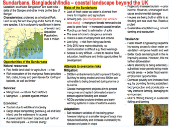
Includes multiple case studies for each of the following topics:
- Population and the Environment
- 1 x Overall population change - Bangladesh
- 1 x Relationship between place and health -
Knowsley, UK
- Coasts
- 1 x coastal landscape beyond the UK -
Sundarbans, Bangladesh
- 1 x local coastal environment - Holderness,
UK
- Global systems and Global Governance
- 1 x a global common - Antarctica
- 1 x a TNC - Apple
- 1 x global food commodity - Coffee
- Hazards
- 1 x multi-hazardous environment - Haiti
- 1 x local hazardous setting - Port-au-
Prince, Haiti
- 1 x HIC recent tropic storm - Hurricane
Katrina 2005
- 1 x LIC recent tropical storm - Typhoon
Haiyan 2013
- Changing Places
- 1 x Local place study - Ladywood,
Birmingham
- 1 x Distant place study - Detroit, USA
- Water and Carbon cycles
- 1 x river catchment at a local scale - River
Brock
- 1 x a tropical rainforest setting - The
Amazon
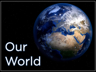
Our World is a comprehensive Geography topic about Planet Earth, suitable for KS1 and lower KS2 (Y1-3).
The planning overview, topic title page and vocabulary page can be downloaded for free here. Lessons include:
L1 – Completing a world map jigsaw
L2 – Identifying the continents and oceans of the world (FREE)
L3 – Where do we live?
L4 – Identifying human and natural features of the world
L5 – Investigating satellite photos of famous world landmarks
L6 – Introduction to compass directions
L7 – Identifying world climate zones
L8 – Identifying the countries and capitals of the UK (FREE)
Each lesson includes a presentation and differentiated activities/worksheets.
If you like this resource, we would appreciate a review! We will happily send you a free resource in return for a review or useful suggestions/feedback. Contact us at ed@teachitforward.co.uk.
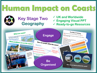
A detailed lesson covering coasts and how they can change. Includes a 38 slide PowerPoint, a detailed plan, 2 writing templates and a challenge activity including another writing template. Covers the impact of tourism, shipping, urbanisation, overfishing and communities on the coast.
Written for UKS2 but can easily be used by all year 3, 4, 5 and 6.
An engaging starter, mixture of independent, paired and group work.
Plenty of opportunities for discussion and for children to share ideas.
Full of lots of interesting images to prompt discussion about geographical features.
An extension activity to challenge the higher ability.
Plenary for children to move on in their learning.
Covers national curriculum learning objectives:
Learn about diverse places, people and resources
Learn about natural and human environments
Learn about the interaction between physical and human processes
Learn about the formation, use of and change of landscapes and environments
All resources included.
All reviews welcome.
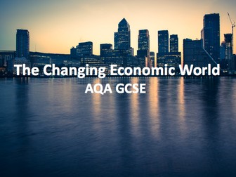
27 part lesson series for the whole of the GCSE module The Changing Economic World. This is complete three sections, the Development Gap, NEE case study (Nigeria) and causes of economic change in the UK. Specifically designed for the new AQA A Geography GCSE. All lesson are for 50 minutes to 1 hour of teaching time. Includes supporting worksheets for lessons - no additional resources are required.
All lessons have a starter, lesson aim, tasks and extensions. Homework is also included. All PowerPoints in the same signature style.
Lesson sequence:
Development Gap:
1 - Measuring development
2 - Classifying development
3 - Demographic transition model
4 - Reducing the Gap (ICT)
5 - Student presentations
6 - Reducing the gap correlation
7 - Managing development disparities
8 - Health and wealth
9 - Development migration
10 - Quality of living and development
11 - Tourism
Nigeria:
12 - Introducing Nigeria
13 - Exploring Nigeria
14 - Nigeria in the wider world
15 - Manufacturing and TNCs in Nigeria
16 - Aid to Nigeria
17 - Managing Environmental Issues
18 - Quality of life in Nigeria
19 - A different perspective: 2 x short documentaries
Causes of economic change in the UK:
20 - Causes of economic change in the UK
21 - Post industrial economy
22 - Science and business parks
23 - Environmental impacts of industry
24 - Rural economies
25 - UK infrastructure development
26 - North South divide
27 - The UK in the wider world
For more resources visit This is Geography. Full SoW for all new GCSE specifications - AQA, Edexcel, OCR, CIE IGCSE, Edexcel IGCSE and Eduqas. As well as over 200 lessons for KS3 and KS2. Want something bespoke designing? Email us for further details info@thisisgeography.co.uk
This lesson is part of The Seaside, a Geography unit designed for students in KS1 and lower KS2, but can also be taught as a stand alone lesson.
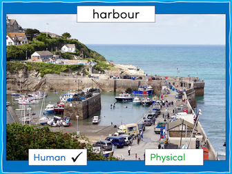
The presentation first explains the difference between human and physical geographical features. It then challenges students to identify a range of seaside features (e.g. cliffs, lighthouse, river mouth) and classify them as human or physical.
In the activity, students identify a range of seaside features and classify them as human or physical.
Easier - Students classify seaside features as human or physical.
Medium - Students label seaside features (with initial letter clues) and classify them as human or physical.
Harder - Students label seaside features (no clues) and classify them as human or physical.
Extension - Students unscramble sentences about the seaside.
If you like this resource, we would appreciate a review! We will happily send you a free resource in return for a review or useful suggestions/feedback. Contact us at ed@teachitforward.co.uk.
**PLEASE SEE MY DISCOUNTED GCSE REVISION BUNDLE BEFORE YOU BUY @ just £4.99!! **
Or get all of my KS3 resources (6x SoW & extras!) for just £12.99
https://www.tes.com/teaching-resource/all-of-my-ks3-resources-12842783
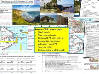
The lesson
A very engaging, A GCSE Geography Coasts Map skills lesson suitable for all Exam boards (AQA, IGCSE, OCR, Edexcel, Cambridge).
Maps, PPT, question sheets and answers.
A perfect lesson for revision or to supplement an existing Coasts SoW. The lesson will very likely take two lessons or more so there is plenty of different content to get through that targets all geography skills and knowledge.
The lesson is a fun and engaging map skills and coasts revision lesson. Contains well planned material for two lessons or even more depending on ability. Answers on the PPT for all tasks. Suitable for KS4 groups as well as more able KS3 groups.
Activities Includes:
Map reading
Co-ordinates
Measuring distance and direction
Photo analysis
Evaluation
Maths skills
Compass and direction
Knowledge on coasts.
Resources
PPT
A map sheet (two different maps)
Task sheet
Teacher notes sheet
Please check out all of my FREE school resources and Geography lessons on my shop where you´ll also find full schemes of work for just £3 and lots of other useful resources… Or purchase all of my resources for just £12.99!
I would really appreciate it if you could leave me a review, thanks!
https://www.tes.com/teaching-resources/shop/ukjoshkelly94
Questions or issues: ukjoshkelly@yahoo.co.uk
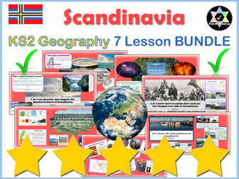
7 Quality lessons covering all aspects of life in Scandinavia and National Curriculum Geography learning objectives.
Powerful images, video links, resources, detailed plans and no preparation needed.
Enjoy my other Scandinavian Units:
Scandinavian Art Unit
Writing Scandinavian Christmas Stories
Check out my other popular Geography units:
Yosemite
Europe
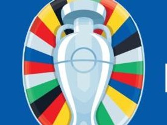
Fantastic cross curricular Men’s Euro 2024 Football booklet -Geography & Sport Project
An outstanding resource that introduces this year’s 2024 FIFA men’s European Cup in Germany.
There are lots of activities for students to complete and access. There are a superb range of cross curricular tasks based on Geography, ICT, Maths, English, Art and Science.
Great for the summer and end of year/term activity !!!
105 lessons for IGCSE geography themes 1, 2 and 3. All lesson are suitable for 50 minutes to 1 hour of teaching time. Includes supporting worksheets for lessons - no additional resources are required.
Population:
1 - Introduction to population
2 - Malthus vs Boserup
3 - Migration
4 - The demographic transition model
5 - Anti-natalist policy, the one-child policy
6 - Over vs underpopulation
7 - Cause of migration
8 - Voluntary vs forced migration - refugees
9 - Ageing population
10 - Population structure
11 - Youthful population
12 - Dense vs sparse population
13 - Jelly baby population
Settlement:
1 - Settlement provision
2 - Settlement structure
3 - Settlement services
4 - Rural settlement service provision
5 - Urban settlement service provision
6 - Burgess model and the CBD
7 - Green and brownfield sites
8 - Problems in urban areas
9 - Manchester
10 - Urban regeneration
11 -Urbanisation
12 - Impacts of urbanisation
13 - Squatter settlements
14 - Squatter settlement case study - Dharavi
Earthquakes and Volcanoes
1 - What are hazards?
2 - Structure of the earth
3 - Types of volcano
4 - Why live in hazardous areas?
5 - Volcano case study
6 - Earthquakes
7 - Disaster response in Haiti
8 - Disaster response in New Zealand
Rivers:
1 - Hydrological cycle and drainage basins
2 - Erosion and deposition
3 - Landforms in the upper course
4 - Landforms in the middle course
5 - Landforms in the lower course
6 - Flooding
7 - Hard and soft engineering
8 - Rivers case study - Somerset
9 - Rivers GIS
Coasts:
1 - Waves
2 - Coastal processes
3 - Landforms processes
4 - Erosional landforms
5 - Depositional landforms
6 - Coral reefs
7 - Threats to coral reefs
8 - Mangroves
9 - Hard and soft engineering
10 - Coastal case study
11 - Assessment
Weather:
1 - Atmospheric circulation
2 - Measuring the weather
3 - Clouds
Climate and Natural Vegetation
1 - Climate zones
2 - Hot deserts
3 - Climate graphs and deserts
4 - Ecosystems
5 - Rainforests
6 - Soil and biodiversity
7 - Opportunities in hot deserts
8 - Causes of deforestation
9 - Impacts of deforestation
10 - Managing the rainforest
11 - Desertification
12 - Sustainable management of the world
Development
1 - Development indicators
2 - Industry
3 - Globalisation
4 - TNCs
5 - TNC case study
6 - Trade game
Food production
1 - Introduction to agriculture
2 - Food shortages
3 - Food supply and shortages (1)
4 - Food supply and shortages (2)
5 -Food production (Indus Valley)
6 - Famine (Horn of Africa)
Industry
1 - Industrial systems
2 - Types of industry
3 - Industrial zones case study
Tourism
1 - Growth of tourism
2 - Pros and cons of tourism growth
3 - Eco tourism
4 - Tourism case study (Jamaica)
Energy
1 - Growing consumption
2 - Non-renewable energy
3 - Renewable energy
4 - Fuelwood and other energy
5 - Nuclear energy
6 - Hydro-electric power case study
7 - Increasing energy
Water
1 - Water supply and use
2 - Water stress
3 - Water management
4 - Lesotho Highland project
Environmental Risk of Development
1 - Soil fertility and threats
2 - Deferestification
3 - Climate change and the enhanced greenhouse effect
4 - Managing the environment
5 - Conserving the environment
For more resources visit This is Geography. Full SoW for all new GCSE specifications - AQA, Edexcel, OCR, CIE IGCSE, Edexcel IGCSE and Eduqas. As well as over 200 lessons for KS3 and KS2. Want something bespoke designing? Email us for further details info@thisisgeography.co.uk
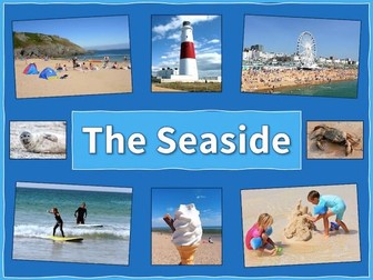
The Seaside is a Geography unit designed for students in upper KS1 and lower KS2 (Y2-Y3).
The planning overview, topic title page and vocabulary page can be downloaded for free here. Lessons include:
L1 – Identifying features of the seaside
L2 – Identifying human and physical features of the seaside
L3 – Locating seaside towns and cities of the UK
L4 – Investigating a seaside town - Lyme Regis
L5 – Identifying islands of the United Kingdom
L6 – Investigating what life is like on a small island
L7 - Packing for a seaside holiday
Each lesson includes a presentation and differentiated activities/worksheets.
If you like this resource, we would appreciate a review! We will happily send you a free resource in return for a review or useful suggestions/feedback. Contact us at ed@teachitforward.co.uk.
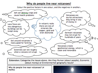
Worksheet with simple categorising task, plus GCSE-style 4-mark question with writing frame / help and example (tourists visiting hot springs in Iceland).
Also see:
My TES shop for all other resources.
This is a blank postcard template that can be printed onto card. The children can then decorate the front as they like (to suit the subject), and write the postcard message and address on the back. They can even design their own stamp. This can be used for many subjects/topics across the curriculum. I have used it for KS1 seaside holidays in the past, but could also be used in Geography, Literacy, MFL etc.
 Quick View