A Geography PowerPoint lesson and 2 worksheets on the topic of Plate Tectonics. The PowerPoint teaches pupils about tectonic plates and the three main types of boundaries - convergent, divergent, transform.
Suitable for KS2/KS3. 16 slides in total - including the cover page and the credits page. 2 pages of worksheets.
Please consider leaving a review if you enjoy the resource.
Thank you for your interest,
Hoppy Times :)
This lesson is designed for KS2 students. It can be taught as a stand alone lesson but is also available as part of three wider units, all of which are available on TES:
-Volcanoes
-Earthquakes
-Volcanoes & Earthquakes
The presentation introduces the idea that the world’s crust is split into tectonic plates and looks at how these are related to volcanoes and earthquakes.
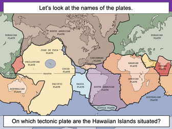
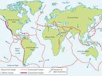
The activity challenges students to identify tectonic plates using a map. It is differentiated two ways:
Easier – Students identify the world’s tectonic plates using a colour-coordinated map.
Harder – Students identify the world’s tectonic plates using a plain map.
Extension – Students use an atlas to find out which tectonic plate countries of the world are located on.
If you like this resource, we would appreciate a review! We will happily send you a free resource in return for a review or useful suggestions/feedback. Contact us at ed@teachitforward.co.uk.
Powerpoint presentation looks at the theory of plate tectonics and how it developed from Alfred Wegener’s earlier theory of continental drift. The presentation includes links to important videos to support learning. A supporting worksheet is also included to assess student understanding of work covered in lesson.
This word search on tectonic plates also doubles as a coloring book!. The solution to the puzzle is included.
Vocabulary Terms Included:
♦ Convection
♦ Convergent
♦ Divergent
♦ Earth Layers
♦ Earthquake
♦ Fault
♦ Hot Spot
♦ Ocean Ridge
♦ Pangaea
♦ Seismologist
♦ Tectonic Plates
♦ Transform
KS3 lesson
Identify that the earths surface is made up of different plate margins.
Describe how different plate margins have different types of hazards.
Explain the causes of hazards on plate margins.
Lesson is fully differentiated, all resources required provided and AFL throughout
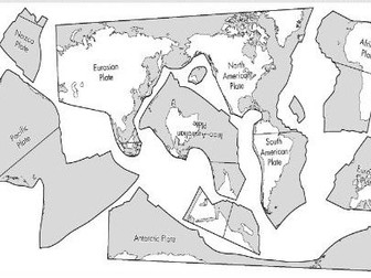
Students cut and paste the puzzle pieces to create a map showing the major plate tectonics of Earth. A great activity for low ability students, or an early finisher activity to extend the understanding of visual learners. Plates will glue into a small rectangle but will not fit together perfectly. This reflects real world conditions of plate tectonics.
Content:
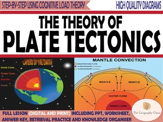
An overview of the characteristics of the layers of the Earth (Inner core, outer core, mantle, crust).
The major tectonic plates.
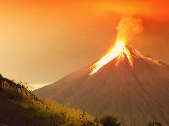
The distribution of earthquakes and volcanoes.
Convection currents.
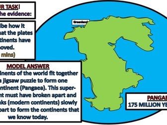
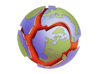
The theory of continental drift.
Resources are:
FACE TO FACE READY- Word Document/PDF/PowerPoint- printable resources for delivery in the classroom.
REMOTE READY- Suitable for online digital learning with links to Google Docs and Google Slides that can be directly posted onto Google Classroom. Students can use digital devices to work independently on the activities from home.
Bonus Materials:
Knowledge Organizer
Interactive assessments (Self-marking Google Form, Keyword Quizlet, Multiple Choice Quizizz)
THIS RESOURCE IS ALSO AVAILABLE AT A DISCOUNT ON THE GEOGRAPHY OASIS WEBSITE (CLICK THIS LINK)
Each resource includes:
Worksheet with activities.
Teacher PowerPoint with diagrams and answer key provided directly onto the slides or in the notes section of each slide.
Direct link to editable Google Slides and Google Doc. Students can work on the activities remotely.
Activate- a starter, an introduction, a stimulus.
Content- The Geographical knowledge- supported by short activities, images, graphs, diagrams.
Review- a plenary, recall activity, AFL, knowledge check.
Useful links- to video clips, websites etc.
What’s included:
• A word document worksheet that includes activities that introduce key terminology, helps students to read graphs, describe distributions and complete structured reading activities.
•The word document is 8 pages. The word document is provided in colour and grayscale.
•This worksheet is also provided as a PDF.
•A PowerPoint version of diagrams and answers.
•The PowerPoint is 25 slides.
Plate Tectonics
This is the Plate Tectonics Differentiation Stations. This product consists of six different stations for students to learn about plate tectonics. The student will learn about the crust, upper mantle, lithosphere, asthenosphere, convection currents, subduction, convergent boundaries, transform boundaries, Pangaea, Alfred Wegener, Mountain building, and much more!
How It Works
Station 1- Vocabulary matching game allows students to match key vocabulary terms with definitions.
Station 2- This station allows students to read an article focusing on plate tectonics and to answer multiple-choice questions.
Station 3- Students are given the opportunity to sketch major concepts within plate tectonics.
Station 4- The student reads a passage and then writes constructed responses.
Station 5- Students read provided fact cards and writes down the correct vocabulary term.
Station 6 – Students cut out the seven continents and construct a model of Pangaea.
Complete lesson - Linked to AQA 2016 Geography syllabus
All resources required for lesson attached.
PowerPoint self explanatory.
LOs
Describe the structure of our planet.
Describe plate tectonics.
Explain the distribution of volcanoes and earthquakes are located
This bundle has three lessons. The first lesson is on the earth's formation and structure. The second lesson is on the plate tectonics theory and evidence of tectonic movement. The final lesson is on plate boundaries and what happens at each boundary. The lessons are all planned in detail with everything you need to deliver them. This bundle as designed for KS3 but the lessons can be adapted easily for GCSE.
A song written to teach students about how plates move at different plate boundaries and the features that are made consequentially. https://www.youtube.com/watch?v=2KajFrmyKpY
Plate Tectonics
The worksheet consists of an information text. Based on this text, there are various exercises such as matching tasks, multiple-choice questions, open questions and true-false questions.
You receive the material and solutions in PDF format for easy printing and in docx format for individual customization.
5 part lesson series for the Edexcel GCSE module Hazardous Earth. This is part of the module to be taught alongside Atmosphere, Climate and Hurricanes. Specifically designed for the new Edexcel Geography GCSE but also suitable for AQA and OCR. All lesson are for 50 minutes to 1 hour of teaching time. Includes supporting worksheets for lessons - no additional resources are required.
All lessons have a starter and lesson aim. Extension tasks and homework also included. All PowerPoints in the same signature style.
Lesson sequence:
1 - Inside the earth
2 - Earthquakes
3 - Haiti case study
4 - New Zealand case study
5 - Volcanoes
For more resources visit This is Geography. Full SoW for all new GCSE specifications - AQA, Edexcel, OCR, CIE IGCSE, Edexcel IGCSE and Eduqas. As well as over 200 lessons for KS3 and KS2. Want something bespoke designing? Email us for further details info@thisisgeography.co.uk
A-Level Geography
Revision powerpoint covering:
plate tectonics theory
plate boundaries and associated landforms & hazards
Earthquakes
Volcanoes
Case studies on earthquakes, volcanoes and tsunamis
This breakout escape room is a fun way for students to test their knowledge of plate tectonics. Full “Letter” sized cards as well as smaller sized cards are provided.
Contents:
♦ Teacher Instructions with Usage Guide and FAQ
♦ 20 Multiple Choice Questions
♦ 5 Decoders for each of the 5 Levels
♦ Student Recording Sheet and Teacher Answer Key
♦ Large Sized Cards and Smaller
♦ Link to an optional, but recommended, digital breakout room