A simple coloured world map with coordinates. Children can use the map to become familiar with countries, continents, oceans and seas! Also using their coordinates skills. Can be printed A4/A3 depending on use.
This lesson is part of Tropical Rainforests, a Geography unit designed for students in KS2, but can also be taught as a stand alone lesson. All resources are compatible with both Microsoft Office and Google Workspace.
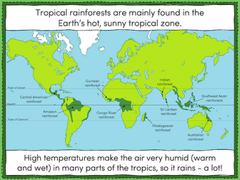
The presentation introduces students to tropical rainforests, including some of the flora and fauna that live in them. Students then learn about the Earth’s tropical belt and the location of the various rainforests within it.
The activity challenges students to label features of a world map including the Equator, the Tropic of Cancer and the Tropic of Capricorn. Students then locate 8 of the world’s tropical rainforests.
Easier - Students use a prompt map and have activity clues.
Harder - Students use a prompt map but have no activity clues.
Extension - Students fill in the missing words in a paragraph about tropical rainforests.
If you like this resource, we would appreciate a review! We will happily send you a free resource in return for a review or useful suggestions/feedback. Contact us at ed@teachitforward.co.uk.
Countries & Continents - World Map Activity
Extend your student’s ‘knowledge of the world’ with this simple but effective challenge.
Before you start: Give every child an atlas (or print off slide 1).
Activity: Locate each country listed on the PowerPoint and identify the continent it belongs to.
Answers provided.
8 slides - fully editable.
This musical world map features 13 topic areas and ties loosely with the OCR GCSE Area of Study 3 - Rhythms of the World.
Topics:
Brazil - Samba
Trinidad and Tobago - Calypso
USA - Blues
African - drumming and a capella singing
Europe and Russia - Western Classical
Greece
Israel and Palestine
Indian
The Punjab - Bhangra
China
Indonesia - Gamelan
Australian
All of the posters are designed to be printed A3 or A4, laminated and stapled/pinned together with string. Each poster features a QR code that either links to our videos on Rhythms of the World or to an example of the music on YouTube.
Editing of the display is encouraged, but please give credit where credit is due.
IMPORTANT - the cover image features an IKEA world map which is not included. A high resolution image of the map is included with the download. The IKEA version can be found here: https://www.ikea.com/gb/en/products/decoration/frames-pictures/mölltorp-blackboard-planner-plan-your-world-art-70319250/
This lesson is part of Understanding Latitude and Longitude, a unit designed for students in upper KS2 and KS3. It can also be taught as a stand-alone lesson.
This lesson explains step-by-step how to find the coordinates of a point on a world map using lines of latitude and longitude.
In the activity, students are challenged to find the latitude and longitude of 12 points in all four quadrants of a world map. It is differentiated three ways:
Easier – Students find coordinates of 12 points in the NE, SE, SW and NW quadrants of the world map respectively. The compass directions are already filled in.
Medium – Students find coordinates of 12 points in the NE, SE, SW and NW quadrants of the world map respectively.
Harder – Students find coordinates of 12 points randomly distributed across the four quadrants of the world map.
Extension – Students are challenged to draw and label 4 more points on to their map.
If you like this resource, we would appreciate a review! We will happily send you a free resource in return for a review or useful suggestions/feedback. Contact us at ed@teachitforward.co.uk.
Hello,
My aim to help teachers reduce their workload and encourage students to love learning geography. I used to spend hours looking for blank editable maps. So, I thought I would make a bank for free blank maps. I have 50 free blanks maps available in my shop.
If you have the time to show your appreciation and click 5 stars it is very helpful for me to see what resources people need.
Good luck
:)
Where in the World?
Whole lesson that is design as an introduction to Geography. This lesson looks to introduce students to key Geographical skills, as well as getting them excited about Geography.
Any question please do get in touch
jacobspong@gmail.com
This world map features bearings questions.
Pupils have to draw the path of a bearing, as well use accurate scale measurements. The scale is provided on the map.
The map also features questions on reverse bearings, where planes are on a return journey.
In order for the scale to be accurate, this map needs to be printed on A3 paper.
A table created for students to actively use in order to find out more about World Rivers, using Google Maps, including the countries that it flows through, the source and more…
Editable resource to help you in your teaching :)
This is world map skill lesson. In the lesson students will be locating continents, oceans and some countries on a world map then creating their own map version. The purpose of the lesson is to improve students location awareness. This is a practical lesson, a good task for any time of the year but especially suitable for end of term run ins or those dreaded period 5s or for use as a cover lesson. There is a quiz at the end to wrap up the lesson as well. The lesson is suitable for all key stages.
World Music Map - INFOGRAPHIC + MUSIC EXAMPLES
This really useful infographic, covers a wide range of traditional and indigenous music from around the globe. All music genres listed come with musical examples to support the resource and aid in learning. It would provide an excellent addition to any lesson on World Music styles, for example the BTEC Level 3 “Unit 36 Studying Music from Around the World”.
The resource comes as HD picture, ready for printing, a HD eBook and a compressed, small file eBook, great for saving to mobile devices for revision and study.
In this package:
INFOGRAPHIC – World Music Map (.pdf High quality)
BOOKLET – World Music Map- MUSIC EXAMPLES (.pdf High quality)
BOOKLET – World Music Map- MUSIC EXAMPLES (.pdf compressed quality)
GOOGLE SLIDES™ - Resource sheet with links to Digital Learning version of material (.pdf)
=========================
PRESENTATION – World Music Map- MUSIC EXAMPLES (.pptx PowerPoint)
PRESENTATION – World Music Map (.pptx PowerPoint)
World Map PPT Template – Attractive World Map Banner in the Background ! Attracts People to Buy – Download World Map PPT Template: Buy World Map PPT Template PowerPoint Templates at less Price. You can Download World Map PowerPoint Template of 3 slides in 7 $ at >>> http://bit.ly/1Nrle3c and 21 and 30 Slides in 25$ Buy Now at >>> http://bit.ly/2eSliOQ
Key Benefits of World Map PPT Template
* Simple color-coded format
* Easy to use with Text
* Facilitates communication with customer
* Save hours on making presentation
* Reasonable price
* Slides – 4 Slides
World Map | World Map PowerPoint Template | World Map PPT Background | World Map PPT Slide | World Map PPT Template
World Map PPT Template – Attractive World Map Banner in the Background ! Attracts People to Buy – Download World Map PPT Template: Buy World Map PPT Template PowerPoint Templates at less Price. You can Download World Map PowerPoint Template of 3 slides in 7 $ and 21 and 30 Slides in 20$ and 25$ Buy Now at >>>> https://goo.gl/C6X49C
Key Benefits of World Map PPT Template
* Simple color-coded format
* Easy to use with Text
* Facilitates communication with customer
* Save hours on making presentation
* Reasonable price
* Slides – 4 Slides
World Map | World Map PowerPoint Template | World Map PPT Background | World Map PPT Slide | World Map PPT Template
The World Map Activity
Lesson Suggestions:
Print and color the maps.
Let the children cut out the continents or oceans and paste them to the matching page. Or make this a small group or classroom activity and laminate the pieces.
Sing song and read a book to round out the lesson.
Use as coloring pages or as a Printable Puzzle.
Materials:
-You will need scissors
-Crayons
-Adhesive (Tape, glue, ect.)
Music: Pair the activity with
“Continents and Oceans” by ABCmouse.com
Youtube: https://www.youtube.com/watch?v=gFIS3aLQPfs
Book: Me on the Map (Dragonfly Books) by Joan Sweeney (Author),
Annette Cable (Illustrator)
I hope you enjoy my products. Be sure to leave a rating and follow my store, Creativeteachersabroad. Keep in touch and get more ideas by liking my Pinterest page: Miss Gabby's Class
You also might enjoy:
Compass Activity
A whole unit of work on World Maps including:
Familiarising yourself with an atlas
Looking at population maps
Classifying countries in South America
Biomes
Ocean currents
Slides include Learning Objectives and links to educational websites to support.
This task gets students to locate different countries and seas on a world map. It then gets them to practice completing a map so that it includes at title, colour, scale, key and border.
 Quick View
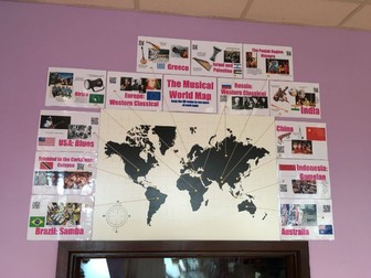 Quick View
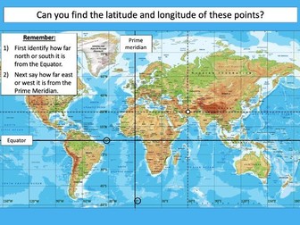 Quick View
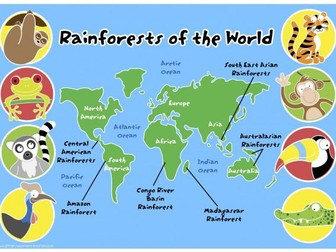 Quick View
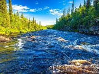 Quick View
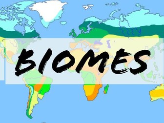 Quick View
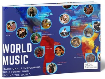 Quick View
 Quick View
 Quick View
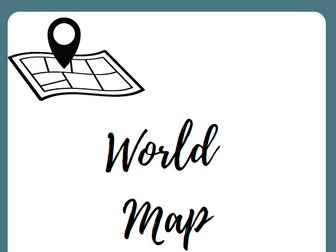 Quick View