DofE: map skills - Scale and SymbolsQuick View
AliRollAliRoll

DofE: map skills - Scale and Symbols

(0)
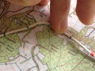
A Duke of Edinburgh maps skills lesson aimed to introduce the different types of map and help students gain understanding of map symbols. Includes 3 activities designed to help students use OS maps. (requires OS maps/printouts of OS maps) Aimed at 13-16 year olds but applicable to older students. This may also be applicable to Geography and outdoor skills classes.
OS map skills revision workbookQuick View
caitiwaltercaitiwalter

OS map skills revision workbook

(11)
Assessing compass directions, measuring distance, grid references, map symbols, contour lines and describing directions, this workbook is a great revision tool for geographers of any age wanting to hone their OS map skills.
Geography Data  Skills Work Booklet - Maps, Graphs, DiagramsQuick View
kstrick92kstrick92

Geography Data Skills Work Booklet - Maps, Graphs, Diagrams

(1)
Enhance your pupils’ geographical skills with a series of interpretation and analysis sheets and questions. This resource includes 8 PowerPoint slides with corresponding questions all focused on a different data presentation method. Ideal for preparing your pupils for exams and revising analysis skills. The high quality slides include annotation, examples and five scaled-ability questions. The data presentation skills included in this resource are: Climate Graphs Population Pyramids Choropleth Maps Scatter Graphs Pie Charts Demographic Transition Model Proportional Symbols Map Divided / Stacked Bar Charts Resource downloaded in PDF and PowerPoint Format.
Topographic Map SkillsQuick View
swintrekswintrek

Topographic Map Skills

12 Resources
A set of photocopiable masters that takes students through the basic skills involved in reading topographic maps including: 1. Introduction and marginal information 2. Symbols and colours 3. Map direction and bearings 4. Height and slope 5. Landforms 6. Area reference and grid reference 7. Scale 8. Measuring distance 9. Measuring area 10. Constructing cross-sections 11. Gradient The bundle also includes a series of ten graded topographic maps and exercises which increase in level of difficulty as students progress through them. Answers are provided for all ten of the topographic map exercises.
Map SkillsQuick View
lozzer111lozzer111

Map Skills

(1)
Very easy to read notes on map skills - includes: compass points, map symbols, scales, relief and grid references. Please comment :)
Topographic Map Skills 11 - GradientQuick View
swintrekswintrek

Topographic Map Skills 11 - Gradient

(0)
A handout on developing topographic maps skills that focuses on gradient. Also available at a vastly reduced price in a bundle of all topographic mapping skills plus 10 graded exercises (with answers) at this link:https://www.tes.com/teaching-resource/topographic-map-skills-11564811
Topographic Map Skills ExercisesQuick View
swintrekswintrek

Topographic Map Skills Exercises

(1)
A series of 10 sets of topographic maps and exercises that introduce students to reading of topographic maps. The maps are graded in level of difficulty from the first which practices the students in elementary topographic map skills and progress to more difficult maps and more difficult topographic map skills. The maps are blackline masters and are easily photocopied. Answers are provided for each of the ten sets of exercises. Also available in a bundle that includes these exercises and handouts on all of the basic topographic map skills: https://www.tes.com/teaching-resource/topographic-map-skills-11564811
Map skills & InterpretationQuick View
omereonyeomereonye

Map skills & Interpretation

(0)
Learning Objectives: At the end of the lesson the students should be able to: (i) Define the term map. (ii) Differentiate between types of maps. (iii) Identify and explain the parts of a map. (iv) Explain the importance of maps. (v) Determine the direction and bearing on maps. (vi) Calculate the distances on maps. (vii) Determine four & six grid references on maps. (viii) Methods of representing Relief on maps. (ix) Identify common landforms/relief on maps. (x) Identify types of slopes on maps. (xi) Calculate gradient on maps. (xii) Determine cross profile on maps. (xiii) Identify and interpret,relief,drainage,settlement and communication patterns on maps. (xiv) Interpret types of land use on maps.
Mapping Skills Game - TanzaniaQuick View
resourcesbyrosemaryresourcesbyrosemary

Mapping Skills Game - Tanzania

(0)
This game is based loosely on Michael Palin's experience in Tanzania while filming 'Pole to Pole'. Introduce by watching the first 5 mins of the YouTube clip. The quotes in the questions are from his diary. I printed and laminated the attached map but you might have one suitable. All instructions are on the Word Doc. The game can be played as a race to last an hour. Students practice longitude and latitude, bearings, distance, population density, using a key, calculating speed/distance/time. Please comment if you notice any errors or have suggestions.
Map Skills Task CardsQuick View
ScienceSpotScienceSpot

Map Skills Task Cards

(0)
These task cards are a great way for students to practice their skills with maps. This product contains 18 cards with multiple choice questions about the various terms used by maps. A recording sheet and an answer key are included. Blank cards are also included for questions to be added, if wanted. The same 18 cards are also available in a non-multiple choice option as well.
Geography: Map skillsQuick View
BFPBFP

Geography: Map skills

(0)
Geography: Map skills A set of TWO crosswords: Map skills 1 and Map skills 2 and TWO bonus puzzles: The India Region and the Australasia Region Suitable for Key Stage 3 Geography, GCSE/IGCSE, or A Levels/IB Diploma. Each crossword makes an excellent group or individual activity and can be used as a revision/reinforcement activity. In-class or for homework. These puzzles are great for stashing away to be used when colleagues are absent. Answers included.
Topographic Map Skills 5 - LandformsQuick View
swintrekswintrek

Topographic Map Skills 5 - Landforms

(1)
Photocopiable handout that introduces students to the various landforms that can be identified on a topographic map using the arrangement of contour lines. Also available in a bundle of all topographic mapping skills plus 10 graded exercises (with answers) at this link:https://www.tes.com/teaching-resource/topographic-map-skills-11564811
Topographic Map Skills Measuring Area -Quick View
swintrekswintrek

Topographic Map Skills Measuring Area -

(1)
Photocopiable handout that shows students how to measure/estimate area on a topographic map. Also available at a vastly reduced price as part of my Topographic Maps Skills Bundle that includes all of the basic topographic map skills as well as a set of graded exercises to practice your students in all of the skills : https://www.tes.com/teaching-resource/topographic-map-skills-11564811
Topographic Map Skills 7 - ScaleQuick View
swintrekswintrek

Topographic Map Skills 7 - Scale

(1)
Photocopiable handout that introduces students to the various scales used on a topographic map and how to compare scales from one map to another. Also available at a vastly reduced price as part of my Topographic Maps Skills Bundle that includes all of the basic topographic map skills as well as a set of graded exercises to practice your students in all of the skills : https://www.tes.com/teaching-resource/topographic-map-skills-11564811
Aerial Photography and Maps: Geography SkillsQuick View
sarah277sarah277

Aerial Photography and Maps: Geography Skills

(0)
A colouring in, revision or homework sheet on the topic of aerial photography, birds eye view, and maps. Designed for my students in the former Soviet Republic of Georgia, with English as a foreign language who were new to the UK curriculum and style of learning. Please leave me a review and I will send you any other resource of your choice for free (contact me: office@oceansproject.com). Check out my other resources at my shop: https://www.tes.com/teaching-resources/shop/sarah277 Let me know if you have any resource requests and I will tailor make a resource for you.
Topographic Map Skills 8 - Measuring distanceQuick View
swintrekswintrek

Topographic Map Skills 8 - Measuring distance

(1)
Photocopiable handout that shows students how to use the scale to work out straight-line and curved-line distances on a topographic map. Also available at a vastly reduced price as part of my Topographic Maps Skills Bundle that includes all of the basic topographic map skills as well as a set of graded exercises to practice your students in all of the skills : https://www.tes.com/teaching-resource/topographic-map-skills-11564811