
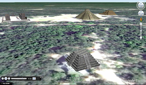
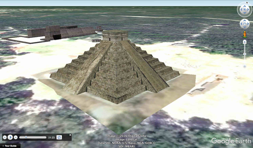

Make a virtual field trip to one of North America’s most famous landmarks; the ancient city of Chichen Itza. You will be using Google Earth to watch a pre-recorded tour of the World Heritage site that is located in Mexico’s Yucatan Peninsula. The trip lasts for 5 minutes and 38 seconds.
The product includes a document of about 15 talking points and interesting facts about one of the Seven Wonders of the Modern World.
It also provides a pdf that describes what you are seeing based on the corresponding minutes in the video. This is so you can pause the tour at the given time stamp and let the class know what they are looking at.
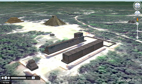
For example the document says at the 3 minute and 1 second mark, “3:01 – 3:15 – The camera is looking right down the middle of the Great Ball Court. An interesting fact about the court is the structure’s acoustics are designed so that a whisper made on one side of the court can be clearly heard 500 feet away, on the other side.”
The tour begins with a view of North America from outer space. You are then zoomed in to the site’s locations to see them from a few different viewpoints. The angles are chosen so the students can get a good idea of the structures’ locations and their physical relationships with each other. Finally, you are taken back out to a long shot of North America.
To watch, all you have to do is click on the file, Google Earth will open and you will be taken on a short trip to the World Heritage site. * Your computer must have Google Earth to watch these tours.
Feel free to visit some other famous landmarks in North America.
1. The Grand Canyon (1:37)
2. The Golden Gate Bridge (3:29)
3. Chichen Itza (5:38)
4. Niagara Falls (1:21)
5. Panama Canal (3:02)
6. Statue of Liberty (2:07)
7. Ole Faithful in Yellowstone National Park (1:26)
8. Gateway Arch in St. Louis, Missouri (1:06)
These tours work great with social studies lessons about famous landmarks, maps, cardinal directions, etc.
Here are a few links to some helpful tutorials on how to use Google Earth.
How to Use Google Earth For Beginners – by Rick Castellini on YouTube - https://www.youtube.com/watch?v=bgjMSBXsFZQ
Beginner Google Earth Tutorial Videos by Google - https://www.google.com.ni/earth/learn/beginner.html
The cover photo is a Creative Commons Attribution 2.0 photo by Walkerssk - found at this link. - https://pixabay.com/en/chichen-itza-mexico-pyramid-1025099/
Google Earth Tour Map Attribution
Map Data: Google, Image Landsat / Copernicus
Data SIO, NOAA, U.S. Navy, NGA, GEBCO
Image IBCAO
Image U.S. Geological Survey
US DEPT of State Geographer
SOI-MBARI
Image © 2016 DigitalGlobe
The product includes a document of about 15 talking points and interesting facts about one of the Seven Wonders of the Modern World.
It also provides a pdf that describes what you are seeing based on the corresponding minutes in the video. This is so you can pause the tour at the given time stamp and let the class know what they are looking at.
For example the document says at the 3 minute and 1 second mark, “3:01 – 3:15 – The camera is looking right down the middle of the Great Ball Court. An interesting fact about the court is the structure’s acoustics are designed so that a whisper made on one side of the court can be clearly heard 500 feet away, on the other side.”
The tour begins with a view of North America from outer space. You are then zoomed in to the site’s locations to see them from a few different viewpoints. The angles are chosen so the students can get a good idea of the structures’ locations and their physical relationships with each other. Finally, you are taken back out to a long shot of North America.
To watch, all you have to do is click on the file, Google Earth will open and you will be taken on a short trip to the World Heritage site. * Your computer must have Google Earth to watch these tours.
Feel free to visit some other famous landmarks in North America.
1. The Grand Canyon (1:37)
2. The Golden Gate Bridge (3:29)
3. Chichen Itza (5:38)
4. Niagara Falls (1:21)
5. Panama Canal (3:02)
6. Statue of Liberty (2:07)
7. Ole Faithful in Yellowstone National Park (1:26)
8. Gateway Arch in St. Louis, Missouri (1:06)
These tours work great with social studies lessons about famous landmarks, maps, cardinal directions, etc.
Here are a few links to some helpful tutorials on how to use Google Earth.
How to Use Google Earth For Beginners – by Rick Castellini on YouTube - https://www.youtube.com/watch?v=bgjMSBXsFZQ
Beginner Google Earth Tutorial Videos by Google - https://www.google.com.ni/earth/learn/beginner.html
The cover photo is a Creative Commons Attribution 2.0 photo by Walkerssk - found at this link. - https://pixabay.com/en/chichen-itza-mexico-pyramid-1025099/
Google Earth Tour Map Attribution
Map Data: Google, Image Landsat / Copernicus
Data SIO, NOAA, U.S. Navy, NGA, GEBCO
Image IBCAO
Image U.S. Geological Survey
US DEPT of State Geographer
SOI-MBARI
Image © 2016 DigitalGlobe
Something went wrong, please try again later.
Bought this and it doesn't connect to google Earth
Report this resourceto let us know if it violates our terms and conditions.
Our customer service team will review your report and will be in touch.
$3.99