
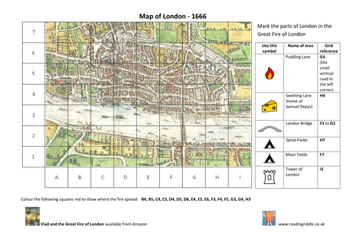
A map of London in 1666 with a grid to mark key sites of the Great Fire. Children mark sites such as Pudding Lane, Tower of London and the fields where Londoners camped after the fire. They are given the grid references to colour the area burned by the fire.
This map covers the journey taken by Vlad and Boxton in the picture book of the events of the Great Fire (Vlad and the Great Fire of London by Kate and Sam Cunningham, which is available on Amazon). The map can be used with the book or works independently too. There are other free resources around the Great Fire of London available from my shop.
For information on my storytelling and drama sessions please visit the Reading Riddle website.
Something went wrong, please try again later.
Awesome. Thank you.
Hi I love the look of this but I can't seem to open the document. Is it still available? thanks
I love this ,a great idea to help kisd realise the way maps work ,totally relatable.
Thank you, it was extremely helpful.
Exactly what I was looking for, for my Year 2's. Simple and elegant map for them to use. Also highly customisable for other children!
Report this resourceto let us know if it violates our terms and conditions.
Our customer service team will review your report and will be in touch.
£0.00