


Tour Niagara Falls with Google Earth (02:10)
Make a virtual field trip to one of North America’s most famous landmarks; Niagara Falls. You will be using Google Earth to watch a pre-recorded tour of the American Falls, Bridal Veil Falls, and Horseshoe Falls.
The product includes a document of about 15 talking points and interesting facts about the famous honeymoon destination.
It provides a pdf that describes what you are seeing based on the corresponding minutes in the video. This is so you can pause the tour at the given time stamp and let the class know what they are looking at.
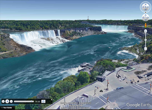
For example the document says from, “1:04 – 1:17 – You are now viewing the three falls with the Rainbow Bridge in the foreground. The tower just past the bridge, on the left, is the Niagara Falls Observation Tower. It is the only place on the American side where you can see all three falls at the same time. An elevator inside the tower will take you down to the Maid of the Mist boat tour. Hornblower Niagara Cruises is the name of the boat tour taken from the Canadian side. Its dock can be seen almost directly across from the American Falls.”
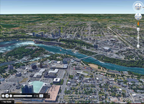
The tour begins with a view of North America from outer space. You are then zoomed in to the site’s locations to see it from a few different viewpoints. The angles are chosen so the students can get a good idea of the three falls’ locations and their physical relationships with each other and their surroundings. Finally, you are taken back out to a long shot of North America.
To watch, all you have to do is click on the file, Google Earth will open and you will be taken on a short trip to the World Heritage site. * Your computer must have Google Earth to watch these tours.
Feel free to visit some other famous landmarks in North America.
1. The Grand Canyon (1:37)
2. The Golden Gate Bridge (3:29)
3. Chichen Itza (5:38)
4. Niagara Falls (2:10)
5. Panama Canal (3:02)
6. Statue of Liberty (2:07)
7. Ole Faithful in Yellowstone National Park (1:26)
8. Gateway Arch in St. Louis, Missouri (1:06)
Here are a few links to some helpful tutorials on how to use Google Earth.
How to Use Google Earth For Beginners – by Rick Castellini on YouTube - https://www.youtube.com/watch?v=bgjMSBXsFZQ
Beginner Google Earth Tutorial Videos by Google - https://www.google.com.ni/earth/learn/beginner.html
Please feel free to email me directly at r_nyg@yahoo.com if you need any assistance.
Google Earth Tour Map Attribution
Map Data: Google, Image Landsat / Copernicus
Data SIO, NOAA, U.S. Navy, NGA, GEBCO
Image IBCAO
Image U.S. Geological Survey
US DEPT of State Geographer
© 2016 DigitalGlobe
Make a virtual field trip to one of North America’s most famous landmarks; Niagara Falls. You will be using Google Earth to watch a pre-recorded tour of the American Falls, Bridal Veil Falls, and Horseshoe Falls.
The product includes a document of about 15 talking points and interesting facts about the famous honeymoon destination.
It provides a pdf that describes what you are seeing based on the corresponding minutes in the video. This is so you can pause the tour at the given time stamp and let the class know what they are looking at.
For example the document says from, “1:04 – 1:17 – You are now viewing the three falls with the Rainbow Bridge in the foreground. The tower just past the bridge, on the left, is the Niagara Falls Observation Tower. It is the only place on the American side where you can see all three falls at the same time. An elevator inside the tower will take you down to the Maid of the Mist boat tour. Hornblower Niagara Cruises is the name of the boat tour taken from the Canadian side. Its dock can be seen almost directly across from the American Falls.”
The tour begins with a view of North America from outer space. You are then zoomed in to the site’s locations to see it from a few different viewpoints. The angles are chosen so the students can get a good idea of the three falls’ locations and their physical relationships with each other and their surroundings. Finally, you are taken back out to a long shot of North America.
To watch, all you have to do is click on the file, Google Earth will open and you will be taken on a short trip to the World Heritage site. * Your computer must have Google Earth to watch these tours.
Feel free to visit some other famous landmarks in North America.
1. The Grand Canyon (1:37)
2. The Golden Gate Bridge (3:29)
3. Chichen Itza (5:38)
4. Niagara Falls (2:10)
5. Panama Canal (3:02)
6. Statue of Liberty (2:07)
7. Ole Faithful in Yellowstone National Park (1:26)
8. Gateway Arch in St. Louis, Missouri (1:06)
Here are a few links to some helpful tutorials on how to use Google Earth.
How to Use Google Earth For Beginners – by Rick Castellini on YouTube - https://www.youtube.com/watch?v=bgjMSBXsFZQ
Beginner Google Earth Tutorial Videos by Google - https://www.google.com.ni/earth/learn/beginner.html
Please feel free to email me directly at r_nyg@yahoo.com if you need any assistance.
Google Earth Tour Map Attribution
Map Data: Google, Image Landsat / Copernicus
Data SIO, NOAA, U.S. Navy, NGA, GEBCO
Image IBCAO
Image U.S. Geological Survey
US DEPT of State Geographer
© 2016 DigitalGlobe
Something went wrong, please try again later.
This resource hasn't been reviewed yet
To ensure quality for our reviews, only customers who have purchased this resource can review it
Report this resourceto let us know if it violates our terms and conditions.
Our customer service team will review your report and will be in touch.
$2.99