


9 PPTs and a word doc activity. All based on OS maps. This is everything I cover with 1st year students (Year 7).
- A 13 slide PPT introducing OS maps, scale, the legend etc…
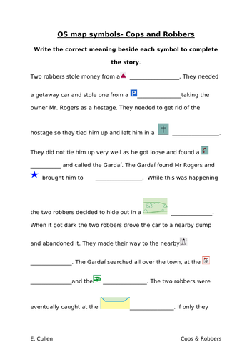
- A word document ‘Cops and Robbers’ Activity to get students using the legend
- A 16 slide PPT on measuring distance (Straight line & Curved Line). Include 2 YouTube links to online demonstrations.
- A 9 slide PPT on 4 figure grid references
- An 8 slide PPT on 6 figure grid references
- A 10 slide PPT on height on an OS map (colour, contour lines, sport heights, triangulation pillar)
- An 11 slide PPT on slope on an OS map (even slope, concave slope, convex slope)
- A 5 slide PPT on direction (N, S, E, W)
- A 13 slide PPT on sketching an OS map (Manageable, step-by-step guide with visual aids)
- An 8 slide PPT on reading the landscape on an OS map (relief, drainage and human landscape)
Each PPT is colourful and well-laid out with transitions and animations already done. Lots of images & extracts of OS maps used as visual aids. Some PPTs contain ‘to do’ and ‘homework’ slides. These refer to the EDCO book ‘Geoplanet’ but can be changed to suit the book you use in your own class.
*For More Geography resources and similar PPTs, see ‘My Shop’ .
Something went wrong, please try again later.
This resource hasn't been reviewed yet
To ensure quality for our reviews, only customers who have purchased this resource can review it
Report this resourceto let us know if it violates our terms and conditions.
Our customer service team will review your report and will be in touch.
£8.00