

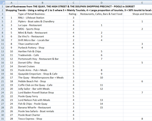
This resource is aimed at giving Geography, Travel and Tourism and Business Studies students from Years 9 through to 11 the experience of handling data related to service industries. The work serves to satisfy the type of work associated with field studies and research. The data is presented on a spreadsheet that highlights the Service Industry of Poole in Dorset. Using the information, students will be able to propose a hypothesis and then attempt to prove or refute the chosen statement.
Within the folder there is a powerpoint presentation that can be used independently as a collection of Geography topics about the English County of Dorset. Specifically it addresses the concepts of Site, Situation and Function of a settlement. The powerpoint presentation alone can be used to support up to 10 contrasting lessons. The photographs can be used for introductions to a number of Human and Physical Geography topics including the following specifics and links:
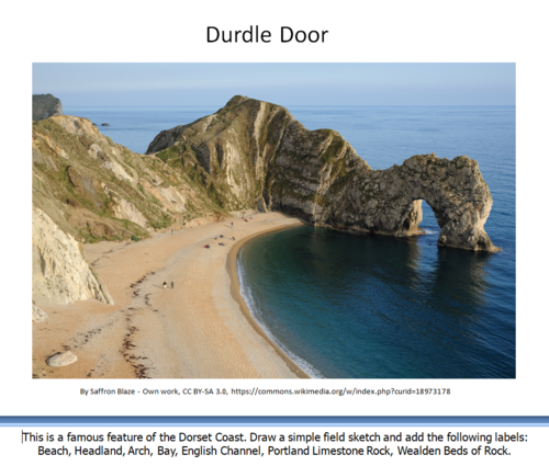
Poole Port, Service Industry, Tourism, Shopping Streets, Spreadsheet statistics, Bays and Headlands, Lulworth Cove, Lulworth Village, Swanage Bay, Groynes, Stair Hole, Durdle Door, Corfe Castle, Dorset Geology, Settlements, Site, Situation, Function and finally a number of excellent photographs that can be converted to field sketch diagrams.
Within the folder there is a powerpoint presentation that can be used independently as a collection of Geography topics about the English County of Dorset. Specifically it addresses the concepts of Site, Situation and Function of a settlement. The powerpoint presentation alone can be used to support up to 10 contrasting lessons. The photographs can be used for introductions to a number of Human and Physical Geography topics including the following specifics and links:
Poole Port, Service Industry, Tourism, Shopping Streets, Spreadsheet statistics, Bays and Headlands, Lulworth Cove, Lulworth Village, Swanage Bay, Groynes, Stair Hole, Durdle Door, Corfe Castle, Dorset Geology, Settlements, Site, Situation, Function and finally a number of excellent photographs that can be converted to field sketch diagrams.
Something went wrong, please try again later.
This resource hasn't been reviewed yet
To ensure quality for our reviews, only customers who have purchased this resource can review it
Report this resourceto let us know if it violates our terms and conditions.
Our customer service team will review your report and will be in touch.
$5.50