
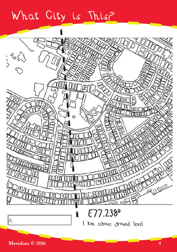

These worksheets of printable maps each have a simple clue on each map that students use to determine what city is outlined on the sheet. Best used with Google Earth.
The clue might be a longitude or latitude.
The task is simple, but the activity is challenging. And some maps involve a bit of problem solving by the student.
Students can also use the layout of the city as well to assist in working out the name.
The worksheets have an answer key at the end. There are 10 maps in all.
***************************************************************************
Learn more about the author at www.malcombrown.com.au
********************************************
100% Money Back guarantee - if there is anything at all about this pack that disappoints or was not as expected, please get back to me and your investment will be completely refunded - no issue at all.
*********************************************
Something went wrong, please try again later.
This resource hasn't been reviewed yet
To ensure quality for our reviews, only customers who have purchased this resource can review it
Report this resourceto let us know if it violates our terms and conditions.
Our customer service team will review your report and will be in touch.
£2.00