I'm a teacher and the Author of the Amazon e-book;' Time Smart Teaching' and my mission is to create Geography resources to help teachers save time and reduce their workload. I am sharing additional time saving tips for teachers on my YOUTUBE channel ' Time Smart Teaching' if you fancy dropping by!
I'm a teacher and the Author of the Amazon e-book;' Time Smart Teaching' and my mission is to create Geography resources to help teachers save time and reduce their workload. I am sharing additional time saving tips for teachers on my YOUTUBE channel ' Time Smart Teaching' if you fancy dropping by!
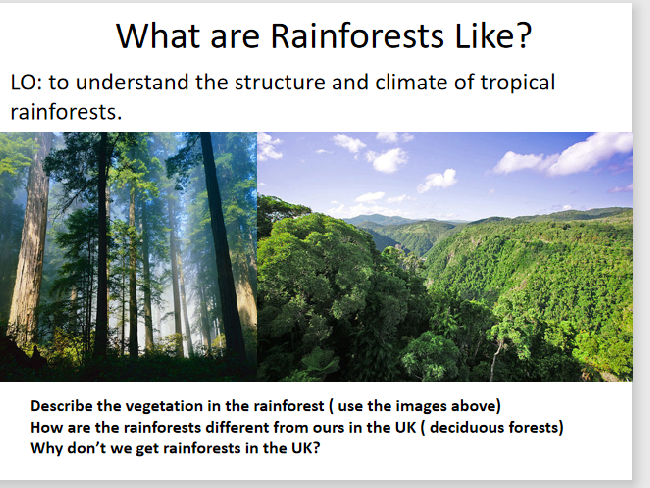
The tropical rainforest biomes are found close to the equator where low pressure systems create bands of high rainfall and long daylight hours that promote high plant growth. Rainforests are densely packed areas of tall vegeatation high amounts of life and biodiversity. This full KS3 lesson and associated sheets and activities give students a full understanding on the layers of the rainforest ecosystem structure, where they are found, and how to analyse and describe the climate of a rainforest using a climate graph. This lesson was originally designed as part of a year 7 ecosystems topic, but would work equally well for year 8. The main task involves students sketching a copy of a diagram on the layers of the rainforest and annotating it in detail using prompts and gap-fill sentences to help them. They then watch a video and make further independant labels.
This game has been adapted to encourage students to use the proper GCSE Geography language of ’ DESCRIBE’ in order to cross off landforms on the sheet such as wave cut platforms, beaches bars, tombolo’s arches and stumps. Instead of pupils asking the questions on the features of people, they ask each other questions on the features of the landforms; is it made by erosion? Is it tall or flat? Is it exposed at low tide? etc. This will encourage students to become lead learners and have dialogue about their knowlege. perfect for an easy, no plan revision or intervention schedule. The best way to play the game is to insert each coloured sheet into a clear plastic wallet and hand each student one of these and a wipeable marker pen. That way you don’t end up continually photocopying and wasting resources.
Coastal Processes in Action - GCSE Physical Geography Lesson
Immerse your students in the dynamic world of coastal processes with our engaging GCSE physical geography lesson. Focused on the impacts of key coastal phenomena such as long shore drift, deposition, and transportation, this session encourages hands-on learning through small group activities.
Key Features:
Interactive Learning: Facilitate understanding of coastal processes by employing small group work, allowing students to use body movements or coded sign language to vividly demonstrate their comprehension.
Focus on Transportation: Delve into the specifics of beach sediment transportation, exploring how constructive waves play a crucial role in moving sand and pebbles along the coast.
Exam Readiness: Evaluate students’ knowledge with a 4-mark exam question, providing a practical application of the concepts learned during the lesson.
Sketching and Image Analysis: Develop essential sketching and image analysis skills, empowering students to interpret and annotate coastal process-related visuals.
Why Choose This Resource?
Kinesthetic Learning: Enhance learning through movement and interaction, making coastal processes come alive for students through physical demonstrations.
Comprehensive Assessment: Assess students’ understanding through a range of activities, from group work to exam-style questions and visual analysis.
Skill Development: Hone sketching and image analysis skills, preparing students for a well-rounded approach to physical geography examination tasks.
Ideal for:
Geography teachers looking to make coastal processes more engaging and interactive.
Educators seeking a comprehensive lesson that incorporates group activities and diverse assessment methods.
Bring coastal processes to life in your geography classroom. Download this lesson now to provide an immersive learning experience and build essential physical geography skills!
Leave Workload Worries Behind with ChatGPT: Your Ultimate Lesson Planning Assistant
Are you tired of educational trends that seem more like passing fads than valuable tools for teachers? Have you ever wanted to harness the power of ChatGPT but found it overwhelming or didn’t know where to begin integrating it into your teaching?
Imagine a world where you can seamlessly embrace this groundbreaking technology without frustration or endless trial and error. What if you could reclaim precious time by having a digital Personal Assistant (PA) at your side 24/7, handling the heavy lifting of lesson planning for you?
Introducing our innovative quick-start PDF guide: “ChatGPT Prompts for Teachers”. With this guide, you can effortlessly prompt ChatGPT to generate engaging and personalized lesson plans and learning activities tailored to your subject area. From dynamic starters and worksheets to structured essay formats and homework assignments – it’s all just a few clicks away.
Download “ChatGPT Prompts for Teachers” now for just £7 and experience the transformative impact of AI on your work-life balance.
Meet Jane Bell, your guide through this journey. As a teacher, mentor, and workload reduction expert, she understands the challenges educators face. Jane is the author of the acclaimed book “Time Smart Teaching,” which equips secondary school teachers with the strategies to work smarter, not harder.
Why You Need ChatGPT:
Let’s face it – teachers can use all the help they can get to work more efficiently and regain their precious time. What’s more, the ability to use ChatGPT is a highly sought-after skill, making you more employable, both in and outside the education industry. Beyond your professional life, it can enhance your personal life as well.
But don’t just take our word for it; here’s what other teachers are saying:
“WOW – I love this!!! What a great resource.” - Loretta Omland
“It’s absolutely BRILLIANT!” - Vee Zeilonka
“Great Guide! Not nearly as overwhelming as I feared!” - Jean Ramsey
In this guide, you will learn:
How to effortlessly navigate, create, and save lesson activities using the free version of ChatGPT.
Copy and paste prompts from our pre-made library, then tweak them to fit your specific needs.
Craft lesson starters, main tasks, learning summaries, and engaging homework ideas.
Plan lessons, step by step, to support students with varying abilities – from those who need extra support to those who crave academic challenges.
Unlock the full potential of AI to streamline your lesson planning and reclaim your time.
Download instantly and embrace the benefits of workload reduction today!
Threats to the tropical rainforest stem from population pressure and climate change. This fragile biome is used for subsidence farming mineral extraction and hydro-electric power. This code breaking resource can be used to introduce threats for the first time, or as a revision activity. This worksheet is designed for Edexcel B specification, however it is suitable for AQA also/ The completion requires access to the textbook 'Edexcel geography B - pages 270-271 in the Pearson Textbook by John Hopkin et al ISBN: 9781446927762. ( page copy available with this resource) The resource is a reading comprehension exercise where they find relevant information from the 2 page of text and images.
This full lesson combines sketching skills and reading comprehension to annotate a diagram of the different rainforest layers: forest floor, understory, canopy and emergent layer. Tropical rainforest biomes are found around 0 degrees lattitude, also known as the equator. Almost all GCSE geography examination boards expect students to have a detailed understanding on the layers and features of the rainforest. This lesson includes a kinathstectic mini-quiz to test students understading on each of the layers; they move around the 4 corners of the room to classify statements on each of the different layer characteristics.
Differentiated resource to allow students to show what they know about the causes effects and solutions to climate change (global warming).
There is a level assesment criteria and a writing frame to help less able students.
Suitable for years 7 and 8
This resource has been brought to you by the author of the Amazon Kindle ebook ’ Time Smart Teaching: 8 Insider Tips to reduce your workload that Schools don’t tell you!. 100% free for Amazon Unlimited subscribers and available to download at the following link;
https://www.amazon.co.uk/Time-Smart-Teaching-Insider-Workload-ebook/dp/B082ZBLFQQ/ref=sr_1_1?keywords=time+smart+teaching&qid=1577972903&s=digital-text&sr=1-1
The introductory chapters are FREE to read on my tes shop page.
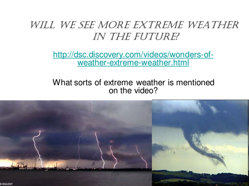
This is a full lesson looking at trends in extreme tornadoes and where they occur. Activities include a mapping activity , analysing data and a group facts race exercise, followed by a journalistic report. designed for 100 minutes.
This resource has been brought to you by the author of the Amazon Kindle ebook ’ Time Smart Teaching: 8 Insider Tips to reduce your workload that Schools don’t tell you!. 100% free for Amazon Unlimited subscribers and available to download at the following link;
https://www.amazon.co.uk/Time-Smart-Teaching-Insider-Workload-ebook/dp/B082ZBLFQQ/ref=sr_1_1?keywords=time+smart+teaching&qid=1577972903&s=digital-text&sr=1-1
The introductory chapters are FREE to read on my tes shop page.
Urbanisation is a concept often misunderstood by Geography students. It refers to the increasing proportion of a nation’s population that is living in towns and cities, rather than the countryside. It is often as a result of large inequality between the standards of living in rural and urban areas in developing countries. This lesson explores the recent boom towards urbanisation and introduces the key terms associated with urban growth, as set out in the AQA spec A GCSE Geography curriculum. This lesson could easily be delivered at ks3 as it sets the foundation for GCSE content.
This resource has been created by the author of 'Time Smart Teaching ; 8 Insider Tips to Reduce Teacher workload that Schools Don’t Teach You. Available as an ebook or hardback on Amazon;
https://www.amazon.co.uk/Time-Smart-Teaching-Insider-Workload-ebook/dp/B082ZBLFQQ/ref=sr_1_1?keywords=time+smart+teaching&qid=1584532024&s=digital-text&sr=1-1
Elevate Your Geography Writing - Literacy Wall Display for GCSE Success
Description:
Unlock the key to GCSE success by mastering essential Geography terminology with our exclusive classroom literacy wall display. Tailored to benefit students of all abilities, this resource is particularly crucial for middle and low-ability learners, offering a visual guide to enhance their grasp of examiners’ language.
Key Features:
Strategic Vocabulary Development: Elevate writing skills by focusing on the precise use of key Geography terminology, a crucial aspect for success in GCSE examinations.
Differentiated Approach: Catering to all ability levels, from basic to advanced, this display provides a comprehensive range of adjectives and acronyms, empowering students to expand their geographical vocabulary effectively.
Visual Prompt: Enhance understanding through a visually appealing guide that clearly illustrates descriptive words aligned with examination themes and topics covered in the new GCSE series.
Grade Differentiation: Bridge the gap between higher and lower ability students, and even distinguish between grade 8 and 9 achievement by emphasizing the importance of well-placed keywords.
Why Choose This Resource?
Exam Preparation: Equip students with the linguistic tools necessary for success in GCSE examinations, ensuring they confidently decode and respond to examiner language.
Inclusive Learning: Provide essential support for middle and low-ability learners, promoting language comprehension and application.
Versatile Application: Suitable for various themes and topics covered in the new GCSE exam series, fostering flexibility and adaptability.
Ideal for:
Geography teachers focused on exam preparation and literacy skills development.
Educators seeking a visually engaging tool to support students in mastering key terminology.
Transform your geography classroom into a hub of linguistic excellence. Download this literacy wall display now to empower your students with the language of success in GCSE examinations!
National Parks were established in 1951 with the Peak District designated as the first official national park in England. They came about after mass protests in the 1930’s from the working classes demanding greater access to the countryside. Since then, many more have been added such as the ’ South Downs’ and ’ New Forest’.
This lesson is based around developing maps skills at ks3 and generating a locational knowledge of the UK by building group ’ maps from memory’ maps of the UK national park. Maps from memory simply involved one person from each group going to look at the completed map outside the classroom, remembering the name and location of one park, then returning to add it onto their group blank map inside the classroom. It is a popular and well known geography learning game.
The students then analyse 2 separate maps of two different national parks ; the Cairngorms national park, and the Pembrookshire Coast. They use the maps to fill in a comparison grid which asks them to identify human and physical attractions. This activity could be supplemented by use of ipads to navigate to BING maps or similar to find out more detailed information. This task could be done individually or or pairs.
Finally there is a plenary discussion on alternative geographical futures ; what would the UK be like now if there were no National parks?
The formation of tropical storms takes place in warm ocean waters near the equator, where the warm sea surface temperatures give rising moisture and energy to power large rotating storms. The threat of climate change may well lead to more frequent and powerful hurricanes globally, and see their paths push further South into the Atlantic.
This resource encompasses 2 full lessons suitable for all ability levels which will look at labelling the features of the storms, describing their characteristics and explaining how they are made. Student will also assess the evidence of the link between climate change and tropical storm frequency. A large range of numerical and graph reading skills developed throughout. A cool link to a fun ’ make your own tropical storm’ app online included which serves as a great learning hook into the lesson.
This lesson has been made by Jane Bell, Author of the ebook ’ Time Smart Teaching: 8 Insider Tips to Reduce Teacher Workload that School Don’t Tell you! Available exclusively on Amazon - 100 free to subscribers of Amazon Unlimited programme. Available at; https://www.amazon.co.uk/Time-Smart-Teaching-Insider-Workload-ebook/dp/B082ZBLFQQ
This lesson looks at why earthquakes form at destructive, constructive and conservative plate margins. Student develop key paper 1 examination skills by learning to draw and annotate diagrams to explain how friction build up and release results in tremmors in the earth’s crust. There is a bonus powerpoint which has an earthquake maps/ GIS/ proportional circle graph analysis, which students have to answer questions on.
A full lesson which can be done with internet research or with textbooks/ revision guides. Student are introduced to a range of landforms and must summarise their formation onto a worksheet grid with links to relevant sites. A detailed annotation task of sand-dunes is included.
Title: Exploring the Boscastle Floods - GCSE Geography Lesson Series
Description:
Delve into the captivating case study of the Boscastle floods in Cornwall 2004 with our comprehensive 2-lesson series designed for GCSE geography. Unravel the causes, effects, and responses to this infamous extreme weather event that left an indelible mark on the landscape and serves as a key case study in the curriculum.
Key Features:
Map Skills Exploration: Engage students with a map skills starter, encouraging them to analyze the OS map of Boscastle to identify clues explaining the vulnerability of the area to flooding, reinforcing understanding of physical causes.
Real-Life Perspectives: Immerse students in the event through a 20-minute video from a BBC documentary, featuring eye-witness accounts and survivor experiences, providing a vivid and emotional connection to the Boscastle floods.
Interactive Worksheet: The main task involves a comprehensive worksheet with facts, statistics, and statements from the flooding, prompting students to classify and analyze information, fostering critical thinking skills.
Practical Application: The second lesson focuses on river flood control and defenses, exploring both hard and soft engineering approaches. Students collaborate in groups to construct a model representing their preferred flood management scheme.
Why Choose This Resource?
Multifaceted Learning: Cover diverse aspects of the Boscastle floods, from map skills to real-life narratives and hands-on model construction, ensuring a well-rounded educational experience.
Current and Relevant: Tackle a well-known GCSE geography case study, providing students with practical insights into the causes and management of extreme weather events.
Engaging Activities: Foster student involvement through interactive tasks, encouraging active participation and knowledge retention.
Ideal for:
GCSE geography teachers seeking a comprehensive and engaging case study resource.
Educators emphasizing practical application and critical thinking skills development.
Elevate your geography lessons with this immersive Boscastle floods series. Download now to captivate your students with a rich exploration of this significant case study!
Food insecurity is where there is not enough physical, or financial access to a range of safe, nutritious food to keep a person healthy. The rise of global production chains and international food trading and export, has created food stress in various regions of the world, This has been made worse by climate change.
This GCSE lesson links to the topic ’ Challenge of Resource Management’ under the AQA spec A curriculum for GCSE Geography.
Each group will be given a different impact of food insecurity ( rising prices, social unrest, malnutrition, environmental degredation). They must explain the impact and come up with at least 3 ideas/ ways in which the problem can be alleviated. Think policy/ technology/ education. They are given 3 internet links to use may use in addition to textbooks to help.
When the group presents their ideas/ solutions back to the group, each student must chose and write the best one and write this on their worksheet grid. This lesson is about students leading learning and teaching each other.
This 4th lesson in our cold climate series ’ Pole to Pole’ allows students to discover Antarctica through a virtual Antarctic cruise. They will learn to annotate the Antarctic icy landscape and discover what tourist activities away those on the cruise. We also compare how the Arctic is different from the Antarctic using a true or false quiz- the students find the answer by studying and comparing the 2 maps of the poles.
Land use refers to what is built on the land at a specific point or the way in which humans use it; for example- residential, industrial, commerce and so on. Land use patterns vary considerably between HIc’s and Lic’s and this lesson examines the Hoyt and Burgess model with a focus task on Brazil. Students must place phototgraphs around their models base on their knowlege of land use patterns. They will start with a quick recap on keywords linked to the theme of urbanisation and urban environments. Fiinally a 4 mark exam question wil test their ability to compare land use between HIc’s and LIC’s. Written for the older AQA GCSE Geography syllabus, but still relevant today.
A bundle of map skills activities for KS3 classes, of mixed ability including using maps to create stories, and analyse human and physical landscapes. Map skills developed includes reading contour lines, using compass directions, concordant coastlines, maps symbols to describe land use and grid references with scale.
Map skills are enabling people to make sense of the world around them by studying spatial patterns and change in a variety of natural and man made landscapes.
This 6th lesson in our cold climate series aimed at year 7 / 8 examines why Arctic sea ice is reducing year on year due to climate change. Students develop their timeline skills to collect information on how ice cores show changes in air quality over time. Students then utilise their completed time line on sea ice to answer questions to test their understanding of the issues presented in the lesson.