Powerpoint covering spit formation, using Spurn as a Case Study
Starter: simple (revision) sorting activity to sequence weathering, erosion, transportation and deposition
Main activities:YouTube videos and a mystery activity to find out how Spurn Head has formed. Pupils use mystery clues to complete and annotate a base map of southern Holderness and the Humber Estuary. Mini-plenary to recognise associated landforms in aerial photos
Second part uses bespoke, high tech (:D) series of diagrams (an animation if you click your mouse quickly enough!) which show why the point of the spit hooks (the role of secondary winds and wave refraction)
Final part gets pupils to sketch and annotate diagrams of Marram and Glasswort to show how dune and salt marsh plants and habitats are interdependent. Differentiated question... 1-3: Describe how salt marshes and sand dunes are held in position by plants 4-6: Why are salt marsh and sand dune environments natural sea defences? 7-9: What could happen to the Humber Estuary if the vegetation at Spurn Head is not protected?
Plenary: the 250 year cycle of spit formation and destruction at the mouth of the Humber Estuary
Powerpoint covering headlands and bays along the destructive Holderness coast
Starter: use maps to locate Flamborough Head
Main activities: sketch bird's eye view diagrams showing before and after erosion has affected a discordant coastline. Followed by a differentiated question: 1-3: How do headlands and bays form? 4-6: What role have chalk and boulder clay played in the formation of Flamborough Head?
7-9: What is wave refraction and how has it affected the Flamborough landscape?
Second part gets pupils to annotate a diagram to show the sequence of cave-arch-stack formation using a series of mixed-up pieces of info (so can be done as a card sort or a mystery). Class then feeds back verbally by responding to a series of images and questions
Third part: pupils work together to find advantages and disadvantages of headlands and bays using clues from a large scale OS map
Plenary: pupils recap learning by describing and explaining features seen in a photo of the chalk at Flamborough
Powerpoint looking at erosion and transportation along Holderness
Starter: the properties of powerful waves, including fetch
Main activities: map work to measure the fetch from Holderness to various coasts of the North Sea. Then radar diagrams are introduced, using a wind rose as an example followed by the pupils constructing a radar to show dominant wave patterns. Then the link between the UK's SW prevailing wind and how it causes NNE dominant waves. Differentiated question... 1-3: What makes a sea wave powerful? 4-6: Explain why North Sea waves can be powerful and damaging
7-9: Refer to data which suggests that Holderness is threatened by powerful waves
Second part gets pupils to draw and label diagrams to compare the features of constructive and destructive waves. They are then asked to assess photos of Holderness to decide which type of wave is affecting that coastline.
Third part looks at the properties of boulder clay and why that soft geology is a problem. Differentiated question: 1-3: Why are the caravan owners worried about the erosion of the cliffs at Hornsea? 4-6: Explain why erosion of the boulder clay is a problem for Holderness
7-9: Explain why the erosion of boulder clay is an economic problem for Holderness businesses
Plenary: pupils are asked to show how they think a typical wave moves, then are shown an animation that describes the circular motion of real wave patterns
Powerpoint introducing Holderness as a Case Study for coastal processes
Starter: use maps to locate Holderness
Main activities: comparison of the properties of chalk (through a memorisation activity and differentiated question) and boulder clay (pupils learn one fact then swap info to answer... What is boulder clay? Where did it come from? How did it get to Yorkshire? What has it got to do with our lesson about coastal landscapes?
Second part gets pupils to draw a sketch map of Holderness then to annotate features that could be lost if erosion continues (using info researched from the internet)
Differentiated question: 1-3: Why are there weaknesses found in chalk? 4-6: Why is Flamborough Head prone to erosion? 7-9: What are the geological reasons for the faults found in the chalk at Flamborough Head?
Plenary shows the wide range of origins for sediment found along Holderness
40 mark SDME assessment in the form of a Powerpoint with associated resources
Background: Why does Holderness suffer from severe coastal erosion? What are the advantages and disadvantages of halting erosion?
Options: Why has hard engineering used to defend Hornsea? Why is soft engineering gaining popularity?
Decision: Do nothing, retreat the line, hold the line or advance the line
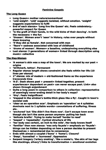
Revision notes for A Level Literature covering Carol Ann Duffy's "Feminine Gospels" collection:
The Long Queen
The Map-Woman
Beautiful
The Diet
The Woman Who Shopped
Work
Tall
Loud
History
Sub
The Virgin’s Memo
Anon
The Laughter of Stafford Girls’ High
A Dreaming Week
White Writing
Gambler
The Light Gatherer
The Cord
Wish
North-West
Death and the Moon
Powerpoint and worksheets beginning with a brief intro to geological timespans. Class and group activities comparing climate data over different periods of Earth history and the reasons for differing conclusions about climate change. Links to videos showing computer simulations of glaciation.
A recap of previous learning, covering contrasts in development between places, development indicators and graph analysis. Aimed at GCSE, KS4, Years 10 and 11. Contains a starter, several activities and a plenary.