Geography Case Study
Lithium is key to green technologies.
The “Lithium Triangle” of Argentina, Bolivia and Chile, holds most of the world’s lithium reserves.
Chinese businesses face allegations of the violation of the rights of local communities, damage to ecosystems and unsafe working conditions.
Argentinian lithium miners surrounded their Chinese managers’ compound and blockaded the entrance with flaming tyres.
This resource includes a variety of lesson activities to pick and choose:
Which Geography keyword is the ODD ONE OUT?
5Ws &1H about Tesla Motors and Elon Musk
5Ws &1H about a photo of lithium salt mounds
In which photo would you be most likely to … meet a worker whose health is at risk?
Critical Thinking: write THREE sentences to LINK these four images (technology: manufacturing, sales, use, waste)
Worksheet and data to construct a dot distribution map of China’s lithium mines around the World
PQE: China’s Lithium Mines - worksheet to analyse the dot distribution map using critical thinking (Patterns, Quantify, Exceptions)
Several slides for screen projection: encourages class evaluation of the positives vs negatives of dot distribution
Slide showing annotated map of Global North vs Global South - encourages analysis of correlation between lithium mining and socio-economic development
Link to video: “Argentina indigenous groups
protest against lithium mining”
Concept Map: The Lithium Triangle (35 snippets of info, to be colour-coded according to Locations, Causes, Effects, Management, Supporting Data)
The concept map info can then be used for:
Thought Chains: The Lithium Triangle - complete the scaffolding to complete six pieces of analysis…
“Chinese firms have been buying lithium mines in South America because…”
“The lithium mining industry in South America is SOCIALLY unsustainable because…”
“The lithium mining industry in South America is ECONOMICALLY unsustainable because…”
“The lithium mining industry in South America is ENVIRONMENTALLY unsustainable because…”
“Electric car makers buy Chinese lithium-ion batteries because…”
“Electric cars are not yet completely sustainable because…”
Geography Web: The Lithium Triangle
Pupils link feature and analyse the connections between the Lithium Triangle and China, Argentina’s government, indigenous people, Tesla Motors
TEACHERS’ BACKGROUND INFORMATION sheets (x3) with links to relevant articles and original BBC News story
Geography Case Study
NEOM is a planned urban development in north-west Saudi Arabia
When completed it will cover 26,500 km² which is larger than the whole of Wales
Why does Saudi Arabia want to build Neom?
Why is the Huwaitat tribe extremely worried?
Abdul Rahim al-Hwaiti: terrorist or martyr?
This resource includes a variety of lesson activities to pick and choose:
Photographic Analysis: The Line (includes worksheet)
Which Geography keyword is the odd one out?
Which country is the odd one out?
Several slides to project and set the scene (locational knowledge, artists’ impressions of the planned districts)
Links to videos of the Neom development: ‘Saudi Arabia’s mega project’; ‘“The Line” under construction in Saudi Arabia’; ‘Neom: The dark side’
Question Grid: Neom (Who? What? Where? etc, vs is… did… can… etc)
The death of Abdul Rahim al-Hwaiti, a Huwaitat tribesman from the area where the Saudi government wants to build Neom. Abdul posted a video on YouTube saying he did not want money to leave his home. A day later and he was shot dead by the Saudi Army
Concept Map: Neom (35 facts, to be colour coded - Locations; Causes; Effects; Management; Supporting Data
Illustrated glossary: Neom (Peak Oil; Economic diversification; Population density; Desalination plant) - definitions given, students to draw their understanding
Thought Chains: Neom - using knowledge learned so far, students complete boxes (because… and so… Therefore… For example…) to show understanding using scaffolding for higher level answers (eg ‘Saudi Arabia needs to DIVERSIFY its industries…’; ‘The region currently has a POPULATION DENSITY of just 6 people per km²’; ‘Neom is / is not ENVIRONMENTALLY sustainable
(‘Planet’)…’)
Geo-Trinity: Neom - students show similarities and differences between the Saudi government, Huwaitat tribespeople and foreign tourists
‘Six Hats’: Neom: - de Bono’s critical thinking technique
Design a sustainable hotel for Neom - choose five (from twenty-four) features of a sustainable resort, then explain the decision (eg eShuttle buses between the hotel and public transportation hubs; Install ‘smart’ showers that limit their usage to a pre-set time; Stock locally-made Fair Trade hotel souvenirs rather than branded/designer items)
Stakeholders conclusion: Neom - students compare different opinions of the development with their own
Teachers’ background information: links to websites, including the original BBC News story and the official Neom site
A decision making exercise which could last a few lessons or be set as a homework project
A property developer is looking to build a five star hotel in San Francisco
Pupils have to decide on the most sustainable county in the Bay Area
Introductory Powerpoint, a project workbook and LOTS of resources are included
The completed project/proposal covers:
Background to tourism in California
The physical hazards threatening San Francisco
Explanation for choosing one of the Bay Area counties
Sustainability (PPP) of the various sites
Reasons for rejecting the others
Consideration of how to make the structure safe from earthquakes
Space for the pupils to be imaginative and design the resort
Eight page booklet : define weather and climate keywords; map the areas of the World to show general effects of Climate Change; SPAG exercise about rising sea levels; questionnaire to survey attitudes towards Climate Change; Moral dilemma about family holidays abroad; personal responses to some religious quotes about the environment; description of how Climate Change may affect our heritage sites
Eight page booklet : define geological keywords; compile a fact file about a geological time period; a SPAG exercise about British geology; a page to research how humans use clay, limestone, marble and sandstone; a moral dilemma: spend money on repairing a historic cathedral or to look after the poor and homeless; complete a database about some of the World's holy rocks and stones; and finally a page to research questions about the UK's geology
Two part fieldwork/coursework booklet
Made with the 2016 GCSE syllabus changes in mind
Follows Footsteps to Investigation (Hypothesis; Expected Outcomes; Methodology; Results; Analysis; Conclusion; Evaluation) plus the chance to write a simple risk assessment for the trip
Part One: COASTAL investigation to answer the hypothesis "Hornsea needs sea defences"
Includes destructive/constructive waves; beach cross section; annotated landscape sketch; tally chart; angle data chart
Part Two: ECONOMIC investigation to answer the hypothesis "Tourism is important for Hornsea"
Includes: Land use survey; bipolar landscape evaluation; visitor questionnaire; sphere of influence; cumulative frequency graph; bar graph; pie graph; Butler's Model
Each page is set up so there is room to add revision notes. The idea is that each page contains one case study so that exam revision can be condensed and is hopefully generic enough for any school’s chosen case studies. Topics are straight from the AQA syllabus…
TECTONIC HAZARDS IN A DEVELOPED COUNTRY
TECTONIC HAZARDS IN A DEVELOPING COUNTRY
TROPICAL STORMS
EXTREME WEATHER IN THE UK
CLIMATE CHANGE IN THE QUATERNARY PERIOD
SMALL SCALE UK ECOSYSTEMS
TROPICAL RAINFORESTS
HOT DESERTS
COLD ENVIRONMENTS
COASTAL LANDFORMS IN THE UK
COASTAL MANAGEMENT IN THE UK
RIVER LANDFORMS IN THE UK
FLOOD MANAGEMENT SCHEMES IN THE UK
GLACIAL LANDFORMS IN THE UK
TOURISM IN A GLACIATED UPLAND AREA OF THE UK
A MAJOR CITY IN A DEVELOPING COUNTRY
IMPROVING QUALITY OF LIFE FOR THE URBAN POOR
A MAJOR CITY IN THE UK
AN URBAN REGENERATION PROJECT
GROWTH OF TOURISM IN DEVELOPING COUNTRIES
RAPID ECONOMIC DEVELOPMENT (Parts One & Two)
SUSTAINABLE INDUSTRY IN THE UK
A LARGE-SCALE AGRICULTURAL DEVELOPMENT
SUSTAINABLE FOOD AND WATER IN DEVELOPING COUNTRIES
A LARGE-SCALE WATER TRANSFER SCHEME
EXTRACTION OF FOSSIL FUELS
RENEWABLE ENERGY IN DEVELOPING COUNTRIES
GEOGRAPHICAL APPLICATIONS: PHYSICAL FIELDWORK
GEOGRAPHICAL APPLICATIONS: HUMAN FIELDWORK
GLOSSARY OF KEY GEOGRAPHICAL TERMS IN THE AQA SYLLABUS
Eight page booklet : define coastal keywords; complete a fact file about a seaside resort; SPAG exercise about Holderness erosion; annotate a map to show human uses of the Humber region; family dilemma about using fossil fuels; write a poem based on a beautiful coastal scene; explain how transport changes have affected holiday habits over time
Powerpoint and worksheets using the UK as a Case Study of drought in a developed country. Completion of a climate graph. Differentiated exam-style questions. Comparisons of human and physical maps and data. Sustainability of four drought management methods used in the UK.
Powerpoint covering headlands and bays along the destructive Holderness coast
Starter: use maps to locate Flamborough Head
Main activities: sketch bird's eye view diagrams showing before and after erosion has affected a discordant coastline. Followed by a differentiated question: 1-3: How do headlands and bays form? 4-6: What role have chalk and boulder clay played in the formation of Flamborough Head?
7-9: What is wave refraction and how has it affected the Flamborough landscape?
Second part gets pupils to annotate a diagram to show the sequence of cave-arch-stack formation using a series of mixed-up pieces of info (so can be done as a card sort or a mystery). Class then feeds back verbally by responding to a series of images and questions
Third part: pupils work together to find advantages and disadvantages of headlands and bays using clues from a large scale OS map
Plenary: pupils recap learning by describing and explaining features seen in a photo of the chalk at Flamborough
Powerpoint looking at erosion and transportation along Holderness
Starter: the properties of powerful waves, including fetch
Main activities: map work to measure the fetch from Holderness to various coasts of the North Sea. Then radar diagrams are introduced, using a wind rose as an example followed by the pupils constructing a radar to show dominant wave patterns. Then the link between the UK's SW prevailing wind and how it causes NNE dominant waves. Differentiated question... 1-3: What makes a sea wave powerful? 4-6: Explain why North Sea waves can be powerful and damaging
7-9: Refer to data which suggests that Holderness is threatened by powerful waves
Second part gets pupils to draw and label diagrams to compare the features of constructive and destructive waves. They are then asked to assess photos of Holderness to decide which type of wave is affecting that coastline.
Third part looks at the properties of boulder clay and why that soft geology is a problem. Differentiated question: 1-3: Why are the caravan owners worried about the erosion of the cliffs at Hornsea? 4-6: Explain why erosion of the boulder clay is a problem for Holderness
7-9: Explain why the erosion of boulder clay is an economic problem for Holderness businesses
Plenary: pupils are asked to show how they think a typical wave moves, then are shown an animation that describes the circular motion of real wave patterns
40 mark SDME assessment in the form of a Powerpoint with associated resources
Background: Why does Holderness suffer from severe coastal erosion? What are the advantages and disadvantages of halting erosion?
Options: Why has hard engineering used to defend Hornsea? Why is soft engineering gaining popularity?
Decision: Do nothing, retreat the line, hold the line or advance the line
A recap of previous learning, covering contrasts in development between places, development indicators and graph analysis. Aimed at GCSE, KS4, Years 10 and 11. Contains a starter, several activities and a plenary.
Powerpoint and worksheets explaining the Enhanced Greenhouse Effect
Starter is an odd-one-out quiz of various human activities which affect climate
Students draw a pie chart showing sources of greenhouse gases from human activities then memorise and sketch the Enhanced Greenhouse Effect
The main work involves constructing a mind map of the effects caused by major greenhouse pollutants (carbon dioxide, water vapour, nitrous oxide, methane and halocarbons)
Differentiated questions:
1-3: How does (a) industry and (b) farming make climate change worse?
4-6: How do humans add to the Greenhouse Effect and climate change?
7-9: Using named chemical compounds, explain how human actions increase the rate of climate change
Plenary: affects of contrails on the short-term weather
Enough for two lessons
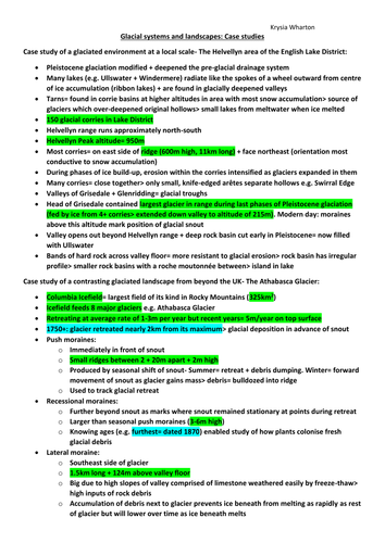
A glaciated environment at a local scale- The Helvellyn area of the English Lake District
A contrasting glaciated landscape from beyond the UK- The Athabasca Glacier
A contrasting glaciated landscape from beyond the UK- The Sápmi region of tundra, northern Europe
Colour coded: green statistics; yellow definitions; blue dates