I've worked in primary teaching for over 10 years and specialise in creating fun and engaging educational resources, particularly for Geography and History.
I've worked in primary teaching for over 10 years and specialise in creating fun and engaging educational resources, particularly for Geography and History.
Investigating Rivers is a Geography unit suitable for KS2 (Y4-6).
The planning overview and topic title page can be downloaded for free here. Lessons include:
L1 - Understanding the water cycle
L2 - Identifying features of a river system
L3 - Identifying characteristics of the three stages of a river
L4 - Investigating features of the River Thames
L5 - Thinking about the different ways we use water
L6 - Understanding the impacts of floods and droughts
Each lesson includes a presentation and differentiated activities/worksheets.
If you like this resource, we would appreciate a review! We will happily send you a free resource in return for a review or useful suggestions/feedback. Contact us at ed@teachitforward.co.uk.
This lesson is an ideal introduction to the world’s three main climate zones.
It is part of Our World, a Geography unit designed for students in KS1 and lower KS2 (Y1-3), but can also be taught as a stand alone lesson.
First the presentation helps students understand that different places in the world have different climates. It then looks at the location of the Equator and North/South poles, and how these relate to the three main climate zones. To keep things simple, these are referred to as hot (tropical), mild (temperate) and cold (frigid).
The activity challenges students to locate the Equator and poles and then identify various climate zones around the world. It is differentiated two ways:
Easier – Students identify the climate zone of 8 numbered points around the world.
Harder – Students identify climate zone and continent of 8 numbered points around the world.
Extension – Students cut and stick pictures of four animals – elephant, lion, polar bear and penguin – onto their world climate zone map.
If you like this resource, we would appreciate a review! We will happily send you a free resource in return for a review or useful suggestions/feedback. Contact us at ed@teachitforward.co.uk.
This lesson is designed for KS2 students. It can be taught as a stand alone lesson but is also available as part of two wider units, both of which are available on TES:
-Volcanoes
-Volcanoes & Earthquakes
First the presentation looks at Mount Etna and Mount Vesuvius in Italy and asks why people choose to live so close to volcanoes.
The activities then challenges students to think about the advantages and disadvantages of living near a volcano:
Partner Activity:
Students sort statements and photos into advantages and disadvantages of living near a volcano.
Writing Activity:
Students write about the advantages and disadvantages of living near a volcano. Stickers and a vocabulary prompt are provided for this activity.
If you like this resource, we would appreciate a review! We will happily send you a free resource in return for a review or useful suggestions/feedback. Contact us at ed@teachitforward.co.uk.
Understanding Trade is a Geography unit suitable for upper KS2 (Y5-6) and is a great way to teach students about global trade.
The planning overview, topic title page and vocabulary page can be downloaded for free here. Lessons include:
L1 – Investigating where the products we buy come from
L2 – Understanding that all products have a supply chain
L3 – Exploring the chocolate supply chain
L4 – Investigating the UK’s biggest exports
L5 – Investigating the highest value exports of different countries
L6 – Is the banana trade fair? (FREE)
Each lesson includes a presentation and differentiated activities/worksheets.
If you like this resource, we would appreciate a review! We will happily send you a free resource in return for a review or useful suggestions/feedback. Contact us at ed@teachitforward.co.uk.
This lesson is an ideal introduction to compass directions for younger children.
It is part of Our World, a Geography unit designed for students in KS1 and lower KS2 (Y1-3), but can also be taught as a stand alone lesson.
The presentation introduces the four cardinal points of the compass (North, East, South and West). It then challenges students to describe the position of objects using these compass directions.
The activity worksheets are differentiated two ways:
Easier – Students describe the position of objects using compass directions (simple questions).
Harder – Students describe the position of objects using compass directions (mixed questions).
Extension – Students fill in the blanks on a compass using different vocabulary.
If you like this resource, we would appreciate a review! We will happily send you a free resource in return for a review or useful suggestions/feedback. Contact us at ed@teachitforward.co.uk.
Mountain Environments is a Geography unit suitable for KS2 (Y4-6) and has everything you need for covering a mountains topic.
The planning overview, topic title page and vocabulary page can be downloaded for free here. Lessons include:
L1 – Identifying the key features of mountains
L2 – Identifying the world’s major mountain ranges
L3 – Locating the world’s famous mountains using latitude and longitude
L4 – Understanding how fold mountains are formed
L5 – Investigating the structure of a volcano (FREE)
L6 – Researching famous world mountains (FREE)
L7 – Investigating mountain climates
Each lesson includes a presentation and differentiated activities/worksheets.
If you like this resource, we would appreciate a review! We will happily send you a free resource in return for a review or useful suggestions/feedback. Contact us at ed@teachitforward.co.uk.
This lesson is part of a wider cross-curricula unit called London Zoo which is designed for KS1 and lower KS2 students (Y2-4).
The animals have escaped at the zoo and the keeper needs your help! The presentation first encourages students to describe the features of animals. It then challenges students to match animals to their names, description and habitat. It includes a variety of animals including fish, birds, mammals, insects and amphibians.
There is a group activity and an individual activity:
Group Activity:
Students match animals to their names, description and habitat (KS1 and KS2 versions).
Individual Activity:
Students match animals to their names, description and habitat on a worksheet. This is differentiated three ways:
Easier – Students match animals to their habitats.
Medium – Students match animals to their description and habitat.
Harder – Students fill in the names of the animals and match them to their description and habitat.
Extension – Students classify animals as fish, birds, mammals, insects or amphibians.
If you like this resource, we would appreciate a review! We will happily send you a free resource in return for a review or useful suggestions/feedback. Contact us at ed@teachitforward.co.uk.
This lesson is designed for KS2 children. It can be taught as a stand alone lesson but is also available as part of two wider units, both of which are available on TES:
-Earthquakes
-Volcanoes & Earthquakes
First the presentation looks at how the Earth’s crust is split into tectonic plates. It then examines the causes of earthquakes, how they occur at the fault lines between tectonic plates and what the hypocentre and epicentre of an earthquake are.
There are three different activities to choose from which can be done in Geography and/or Literacy lessons. These include:
Quiz Activity
Students watch a video clip about earthquakes and answer comprehension questions about it. This is differentiated two ways.
Cloze Procedure Activity
Students fill in the blanks in an explanation text about earthquakes. This is differentiated two ways.
Writing Activity
Student write an explanation text about earthquakes. This is differentiated three ways and comes with vocabulary and sentence starter prompts.
If you like this resource, we would appreciate a review! We will happily send you a free resource in return for a review or useful suggestions/feedback. Contact us at ed@teachitforward.co.uk.
This lesson is part of Investigating Rivers, a unit designed for upper KS2 (Y4-6).
The presentation takes students on a journey from the source to the mouth of the River Thames. Starting at Thames Head, the source of the River Thames, students investigate maps and satellite photos and try to identify river features along the way. Other locations include Windsor Castle, the Isle of Dogs in London and the mouth of the river at Southend-on-Sea.
The writing-based activity challenges students to first label each map/satellite photo and then write a paragraph describing the location and river features they can see. It is differentiated two ways:
Easier – Students have maps/satellite photos and cloze procedure paragraphs to complete.
Harder – Students have maps/satellite photos, a wordbank and write their own paragraphs.
If you like this resource, we would appreciate a review! We will happily send you a free resource in return for a review or useful suggestions/feedback. Contact us at ed@teachitforward.co.uk.
Volcanoes & Earthquakes is an exciting extended Geography unit designed for students in KS2.
The planning overview, topic title page and vocabulary page can be downloaded for free here. Lessons include:
L1 – Understanding the structure of the Earth
L2 – Investigating the structure of a volcano (FREE)
L3 – Locating the world’s famous volcanoes
L4 – Investigating the five deadly features of a volcanic eruption
L5 – Understanding tectonic plates
L6 – Exploring the effects of volcanic eruptions on Montserrat
L7 – Why do people live near volcanoes?
L8 – Understanding the causes of earthquakes
L9 – Investigating the five deadly features of an earthquake
L10 – Researching earthquakes using Wikipedia
L11 – Locating the world’s biggest earthquakes using latitude & longitude
L12 – Writing a fact file about a famous earthquake
Each lesson includes a presentation and differentiated activities/worksheets.
A FREE newspaper report template is also included in this unit.
If you like this resource, we would appreciate a review! We will happily send you a free resource in return for a review or useful suggestions/feedback. Contact us at ed@teachitforward.co.uk.
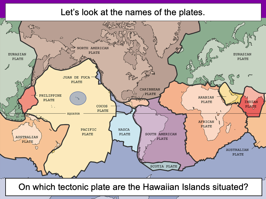
This lesson is designed for KS2 students. It can be taught as a stand alone lesson but is also available as part of three wider units, all of which are available on TES:
-Volcanoes
-Earthquakes
-Volcanoes & Earthquakes
The presentation introduces the idea that the world’s crust is split into tectonic plates and looks at how these are related to volcanoes and earthquakes.
The activity challenges students to identify tectonic plates using a map. It is differentiated two ways:
Easier – Students identify the world’s tectonic plates using a colour-coordinated map.
Harder – Students identify the world’s tectonic plates using a plain map.
Extension – Students use an atlas to find out which tectonic plate countries of the world are located on.
If you like this resource, we would appreciate a review! We will happily send you a free resource in return for a review or useful suggestions/feedback. Contact us at ed@teachitforward.co.uk.
This lesson is part of Understanding Latitude and Longitude, a unit designed for students in upper KS2 and KS3. It can also be taught as a stand-alone lesson.
The presentation introduces the concept of lines of latitude and longitude, including the Equator and Prime Meridian, and goes on to explain their purpose and relationship to Earth’s hemispheres and poles.
In the activity, students have to identify all of these features on diagrams of the Earth. It is differentiated two ways and includes an extension:
Easier – Students have label clues and a vocabulary bank to help them.
Harder – Students have only a vocabulary bank to help them.
Extension – Students fill in the missing words in a text about latitude and longitude.
If you like this resource, we would appreciate a review! We will happily send you a free resource in return for a review or useful suggestions/feedback. Contact us at ed@teachitforward.co.uk.
This lesson is part of Exploring Brazil, a Geography unit designed for students in KS2 (Y4-6), but can also be taught as a stand alone lesson.
It is a great introduction to using 6-figure grid references. The presentation first recaps how to find 4-figure grid references, then demonstrates how to find 6-figure grid references step by step.
There are two activities:
Activity 1:
Students locate 16 Brazilian cities using 4-figure grid references.
Extension – Students answer questions involving grid references and compass directions.
Activity 2:
Students have a go at describing the location of Brazilian cities more precisely using 6-figure grid references.
Easier – Students use mini-grids to help them locate 16 cities using 6-figure grid references.
Medium – Students use mini-grids to locate 8 cities, then estimate 6-figure grid references for 8 more cities.
Harder – Students have to estimate 6-figure grid references for all 16 cities (i.e. no mini-grids).
If you like this resource, we would appreciate a review! We will happily send you a free resource in return for a review or useful suggestions/feedback. Contact us at ed@teachitforward.co.uk.
This lesson is designed for KS2 students. It can be taught as a stand alone lesson but is also available as part of two wider units, both of which are available on TES:
-Volcanoes
-Volcanoes & Earthquakes
First the presentation introduces some of the world’s most famous volcanoes and classes them as active, dormant or extinct.
The activity then challenges students to locate volcanoes using an atlas or the internet (e.g. Google maps). Alternatively, a map of famous world volcanoes is also provided.
Easier – Students locate volcanoes using the map of famous volcanoes (writing numbers).
Medium – Students locate volcanoes using the map of famous volcanoes (writing volcano names).
Harder – Students locate volcanoes using an atlas.
(N.B. It is recommended you check the atlas has the relevant maps prior doing the activity.)
If you like this resource, we would appreciate a review! We will happily send you a free resource in return for a review or useful suggestions/feedback. Contact us at ed@teachitforward.co.uk.
The Seaside is a Geography unit designed for students in upper KS1 and lower KS2 (Y2-Y3).
The planning overview, topic title page and vocabulary page can be downloaded for free here. Lessons include:
L1 – Identifying features of the seaside
L2 – Identifying human and physical features of the seaside
L3 – Locating seaside towns and cities of the UK
L4 – Investigating a seaside town - Lyme Regis
L5 – Identifying islands of the United Kingdom
L6 – Investigating what life is like on a small island
L7 - Packing for a seaside holiday
Each lesson includes a presentation and differentiated activities/worksheets.
If you like this resource, we would appreciate a review! We will happily send you a free resource in return for a review or useful suggestions/feedback. Contact us at ed@teachitforward.co.uk.
This resource is designed for teaching the Great Fire of London KS1 History unit. You can download the planning for free here. It is suitable for Year 2 children and more able Year 1 children.
The presentation explores how the Great Fire of London gave birth to the very first fire brigades in the late 17th century. It also looks at how fire safety has improved, including changes in our homes and innovations in fire fighting equipment.
There are two differentiated worksheets which challenge children to sort fire safety related pictures and vocabulary into ‘Now’ and ‘Then (1666)’. They include:
a standard activity sheet with eight words/phrases for children to draw and label
an easier activity sheet (with stickers) with ten words/phrases for children to label
If you like this resource, we would appreciate a review! We will happily send you a free resource in return for a review or useful suggestions/feedback. Contact us at ed@teachitforward.co.uk.
This is the first lesson in Mountain Environments, a Geography unit designed for students in upper KS2 (Y4-6).
First the presentation introduces students to the topic and looks at some of the activities people do in mountains. It then introduces the key features of a mountain range.
The activity challenges students to identify the key features of a mountain environment. It is differentiated three ways:
Easier – Students identify 8 key features of mountains.
Medium – Students identify 10 key features of mountains.
Harder – Students label the key features of mountains in their exercise book.
Extension – Students match mountain vocabulary to their definitions.
If you like this resource, we would appreciate a review! We will happily send you a free resource in return for a review or useful suggestions/feedback. Contact us at ed@teachitforward.co.uk.
This lesson is part of Investigating Rivers, a unit designed for upper KS2 (Y4-6).
It introduces many key river concepts and a wide range of related vocabulary. First the presentation recaps the main processes of the water cycle. It then introduces some of the well known features of river systems (e.g. waterfalls and lakes). There are two activities:
Group Activity:
Students are challenged to match eight features of river systems to photos, satellite images and maps. This activity can easily be differentiated by giving groups different numbers of cards.
Individual Activity:
In the worksheet activity students identify the same features on a simplified drawing of a river system. It is differentiated two ways:
Easier – Students identify river features and complete cloze procedure definitions.
Harder – Students identify river features and write their own definitions of four river features.
If you like this resource, we would appreciate a review! We will happily send you a free resource in return for a review or useful suggestions/feedback. Contact us at ed@teachitforward.co.uk.
This is set of guided reading sessions designed to be used alongside The Diary of a Killer Cat by Anne Fine. These resources can be used across KS2.
The book follows the misadventures of a sarcastic cat called Tuffy who has a habit of bringing dead animals back to his owner, Ellie.
It is ideal for readers in Year 3 and Year 4 but can also be used with less-able readers in Year 5 and Year 6.
Included are 11 sessions of guided reading comprehesion questions. All questions are colour-coded and include:
Vocabulary questions
Retrieval questions
Summary questions
Inference questions
Prediction questions
Compare and contrast questions
Author choice questions
All resources are fully-editable and can be adapted easily if necessary. Answers are included.
If you like this resource, please review it. If you have any suggestions or feedback, contact me at ed@teachitforward.co.uk.
This resource is part of Tropical Rainforests, a Geography unit designed for students in KS2. It is compatible with both Microsoft Office and Google Workspace.
The planning overview and topic title page for Tropical Rainforests can be downloaded for free here.
This knowledge organiser is designed to support the teaching of tropical rainforests and outlines the key concepts and subject knowledge of the topic.
As well as being fully editable, it comes with a colour-coded version to support younger students.
If you like this resource, we would appreciate a review! We will happily send you a free resource in return for a review or useful suggestions/feedback. Contact us at ed@teachitforward.co.uk.