I've worked in primary teaching for over 10 years and specialise in creating fun and engaging educational resources, particularly for Geography and History.
I've worked in primary teaching for over 10 years and specialise in creating fun and engaging educational resources, particularly for Geography and History.
Exploring the UK is a Geography unit suitable for KS1 and lower KS2 (Y2-4).
The planning overview, topic title page and vocabulary page can be downloaded for free here. Lessons include:
L1 – Identifying the countries and capitals of the UK & Ireland (FREE)
L2 – Locating UK cities using compass directions
L3 – Identifying human & physical features of the UK
L4 – Investigating satellite photos of the UK
L5 – Comparing the city and the countryside
L6– Identifying famous features and characteristics of countries of the UK
L7 – Identifying flags of the United Kingdom
L8 – Identifying the four seasons of weather in the UK
Optional lesson – Identifying the countries and capital cities of Europe
Each lesson includes a presentation and differentiated activities/worksheets.
If you like this resource, we would appreciate a review! We will happily send you a free resource in return for a review or useful suggestions/feedback. Contact us at ed@teachitforward.co.uk.
This lesson is part of Exploring the United Kingdom, a Geography unit designed for KS1 and lower KS2 (Y2-4).
This lesson encourages students to identify geographical features found in the city/countryside and think about the similarities and differences between urban and rural areas in the UK.
First the presentation shows small segments of images from around the United Kingdom and challenges students to work out whether they are from the city or countryside.
Children then complete a Venn diagram-based activity which can be done in two ways:
Group activity:
In pairs or trios, children sort images of the city and countryside using a Venn diagram. This can also be done using two PE hoops and makes a nice classroom display.
Individual activity:
Students sort city and countryside vocabulary using a Venn diagram:
Easier – Students sort 12 city/countryside words
Harder – Students sort 18 city/countryside words
If you like this resource, we would appreciate a review! We will happily send you a free resource in return for a review or useful suggestions/feedback. Contact us at ed@teachitforward.co.uk.
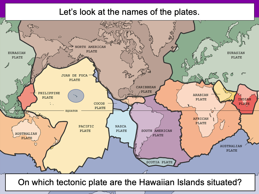
This lesson is designed for KS2 students. It can be taught as a stand alone lesson but is also available as part of three wider units, all of which are available on TES:
-Volcanoes
-Earthquakes
-Volcanoes & Earthquakes
The presentation introduces the idea that the world’s crust is split into tectonic plates and looks at how these are related to volcanoes and earthquakes.
The activity challenges students to identify tectonic plates using a map. It is differentiated two ways:
Easier – Students identify the world’s tectonic plates using a colour-coordinated map.
Harder – Students identify the world’s tectonic plates using a plain map.
Extension – Students use an atlas to find out which tectonic plate countries of the world are located on.
If you like this resource, we would appreciate a review! We will happily send you a free resource in return for a review or useful suggestions/feedback. Contact us at ed@teachitforward.co.uk.
This lesson is part of The Seaside, a Geography unit designed for students in KS1 and lower KS2, but can also be taught as a stand alone lesson.
The presentation first explains the difference between human and physical geographical features. It then challenges students to identify a range of seaside features (e.g. cliffs, lighthouse, river mouth) and classify them as human or physical.
In the activity, students identify a range of seaside features and classify them as human or physical.
Easier - Students classify seaside features as human or physical.
Medium - Students label seaside features (with initial letter clues) and classify them as human or physical.
Harder - Students label seaside features (no clues) and classify them as human or physical.
Extension - Students unscramble sentences about the seaside.
If you like this resource, we would appreciate a review! We will happily send you a free resource in return for a review or useful suggestions/feedback. Contact us at ed@teachitforward.co.uk.
Earthquakes is an exciting Geography unit designed for students in KS2.
The planning overview, topic title page and vocabulary page can be downloaded for free here. Lessons include:
L1 – Understanding the structure of the Earth
L2 – Understanding tectonic plates
L3 – Understanding the causes of earthquakes
L4 – Investigating the five deadly features of an earthquake
L5 – Researching earthquakes using Wikipedia
L6 – Locating the world’s biggest earthquakes using latitude & longitude
L7 – Writing a fact file about a famous earthquake
Each lesson includes a presentation and differentiated activities/worksheets.
If you like this resource, we would appreciate a review! We will happily send you a free resource in return for a review or useful suggestions/feedback. Contact us at ed@teachitforward.co.uk.
This set of resources is designed for teaching the KS2 Stone Age History unit. It includes an engaging presentation, differentiated worksheets and stickers. The activity helps children categorise foods into those ‘hunted’ and those ‘gathered’. This reinforces the idea that Stone Age humans were primarily ‘hunter-gatherers’.
There are three differentiated worksheets:
- one with vocabulary for less able children
- one with fill-in-the-blank sentences using commas in lists
- one which extends more able children by asking them to explain how Stone Age humans hunted
The stickers will print out on Avery address labels (21 per page).
If you like this resource, we would appreciate a review! We will happily send you a free resource in return for a review or useful suggestions/feedback. Contact us at ed@teachitforward.co.uk.
This lesson is part of Mountain Environments, a Geography unit designed for students in upper KS2 (Y4-6).
First the presentation looks at features of a mountain climate including lower temperatures and increased rainfall. It then focuses in more detail on the climate of Mount Everest.
There are two activities:
Interpreting climate graphs
In this activity students look at and answer questions about temperature graphs for both the summit and base camp of Mount Everest. It is differentiated two ways:
Easier – Students answer questions about temperature graphs for Mount Everest (suitable for Year 4 and 5).
Harder – Students answer questions about temperature graphs for Mount Everest (suitable for Year 6).
Creating a climate graph in Excel
In this ICT activity, students create their own climate graph, including temperature and rainfall, for the summit of Mount Everest using Microsoft Excel.
If you like this resource, we would appreciate a review! We will happily send you a free resource in return for a review or useful suggestions/feedback. Contact us at ed@teachitforward.co.uk.
This resource is designed for teaching the Great Fire of London KS1 History unit. You can download the planning for free here. It is suitable for Year 2 children and more able Year 1 children.
The presentation explores how the Great Fire of London gave birth to the very first fire brigades in the late 17th century. It also looks at how fire safety has improved, including changes in our homes and innovations in fire fighting equipment.
There are two differentiated worksheets which challenge children to sort fire safety related pictures and vocabulary into ‘Now’ and ‘Then (1666)’. They include:
a standard activity sheet with eight words/phrases for children to draw and label
an easier activity sheet (with stickers) with ten words/phrases for children to label
If you like this resource, we would appreciate a review! We will happily send you a free resource in return for a review or useful suggestions/feedback. Contact us at ed@teachitforward.co.uk.
Volcanoes is an exciting Geography unit designed for students in KS2.
The planning overview, topic title page and vocabulary page can be downloaded for free here. Lessons include:
L1 – Understanding the structure of the Earth
L2 – Investigating the structure of a volcano (FREE)
L3 – Locating the world’s famous volcanoes
L4 – Investigating the five deadly features of a volcanic eruption
L5 – Understanding tectonic plates
L6 – Exploring the effects of volcanic eruptions on Montserrat
L7 – Why do people live near volcanoes?
Each lesson includes a presentation and differentiated activities/worksheets.
A FREE newspaper report template is also included in this unit.
If you like this resource, we would appreciate a review! We will happily send you a free resource in return for a review or useful suggestions/feedback. Contact us at ed@teachitforward.co.uk.
This lesson is part of Tropical Rainforests, a Geography unit designed for students in KS2, but can also be taught as a stand alone lesson. All resources are compatible with both Microsoft Office and Google Workspace.
First, the presentation introduces students to the different layers of the rainforest and some of the animals that live in each layer.
Students then complete a range of activities:
Activity 1:
In pairs, students match the layers of a tropical rainforest to descriptions.
Easier - Students have multicoloured descriptions. They match each layer to one green, blue and purple description.
Harder - Students have plain black descriptions. They match each layer to three other descriptions.
Activity 2:
Students identify and label the four layers of a tropical rainforest.
Easier - Students write one word for each layer.
Harder - Students write two words for each layer.
Extension:
Students cut out pictures of tropical rainforest animals and stick them in the layer in which they live.
If you like this resource, we would appreciate a review! We will happily send you a free resource in return for a review or useful suggestions/feedback. Contact us at ed@teachitforward.co.uk.
The Seaside is a Geography unit designed for students in upper KS1 and lower KS2 (Y2-Y3).
The planning overview, topic title page and vocabulary page can be downloaded for free here. Lessons include:
L1 – Identifying features of the seaside
L2 – Identifying human and physical features of the seaside
L3 – Locating seaside towns and cities of the UK
L4 – Investigating a seaside town - Lyme Regis
L5 – Identifying islands of the United Kingdom
L6 – Investigating what life is like on a small island
L7 - Packing for a seaside holiday
Each lesson includes a presentation and differentiated activities/worksheets.
If you like this resource, we would appreciate a review! We will happily send you a free resource in return for a review or useful suggestions/feedback. Contact us at ed@teachitforward.co.uk.
Exploring Brazil is a Geography unit designed for students in KS2 (Y4-6).
The planning overview, topic title page and vocabulary page can be downloaded for free here. Lessons include:
L1 – Identifying the countries and capitals of South America
L2 – Writing a Brazil fact file
L3 – Using 4 and 6-figure grid references to locate Brazilian cities
L4 – Identifying the human and physical features of Brazil
L5 – Exploring Brazil’s ecosystems
L6 – Investigating Brazil’s weather and climate
Each lesson includes a presentation and differentiated activities/worksheets.
If you like this resource, we would appreciate a review! We will happily send you a free resource in return for a review or useful suggestions/feedback. Contact us at ed@teachitforward.co.uk.
This resource is part of Exploring Australia, a Geography unit designed for students in upper KS1 and lower KS2 (Y2-Y4). All resources are compatible with both Microsoft Office and Google Workspace.
First the presentation introduces the concepts of human and physical before looking at some of Australia’s famous landmarks, from the Sydney Opera House to the Great Barrier Reef.
The activity challenges students to look at ten famous geographical features of Australia and identify them as human or physical:
Easier - Students look at each feature and circle human or physical.
Medium - Students draw each feature and circle human or physical.
Harder - Students identify each feature and label as human or physical.
Extension - Students complete a cloze-procedure paragraph about Australia.
If you like this resource, we would appreciate a review! We will happily send you a free resource in return for a review or useful suggestions/feedback. Contact us at ed@teachitforward.co.uk.
This lesson is part of Understanding Latitude and Longitude, a unit designed for students in upper KS2 and KS3. It can also be taught as a stand-alone lesson.
The presentation introduces the concept of lines of latitude and longitude, including the Equator and Prime Meridian, and goes on to explain their purpose and relationship to Earth’s hemispheres and poles.
In the activity, students have to identify all of these features on diagrams of the Earth. It is differentiated two ways and includes an extension:
Easier – Students have label clues and a vocabulary bank to help them.
Harder – Students have only a vocabulary bank to help them.
Extension – Students fill in the missing words in a text about latitude and longitude.
If you like this resource, we would appreciate a review! We will happily send you a free resource in return for a review or useful suggestions/feedback. Contact us at ed@teachitforward.co.uk.
This lesson is part of Tropical Rainforests, a Geography unit designed for students in KS2, but can also be taught as a stand alone lesson. All resources are compatible with both Microsoft Office and Google Workspace.
First, the presentation introduces students to deforestation and then looks at the reasons the Amazon rainforest is being cut down (i.e. logging, farming and house building). Students are then encouraged to think about the positive and negative impacts of deforestation.
In the activity, students arrange these impacts of deforestation into a diamond 9, ranking them in terms of importance.
Easier - Students complete the diamond 9 and explain their reasoning for the most important statement they chose.
Harder - Students complete the diamond 9 and explain their reasoning for the most and least important statements they chose.
Extension - Students match topic words to their meanings.
If you like this resource, we would appreciate a review! We will happily send you a free resource in return for a review or useful suggestions/feedback. Contact us at ed@teachitforward.co.uk.
This resource is designed for teaching the Great Fire of London KS1 History unit. You can download the planning for free here. It is suitable for Year 2 children and more able Year 1 children.
The presentation introduces the context of the Great Fire of London and challenges children to find reasons for the rapid spread of the fire. The literacy-based activity reinforces this learning .
Two differentiated worksheets challenge children to match reasons for the Great Fire of London with sentence starters:
- the standard activity sheet gives five possible reasons
- an easier activity sheet gives just two reasons to choose from per sentence starter
If you like this resource, we would appreciate a review! We will happily send you a free resource in return for a review or useful suggestions/feedback. Contact us at ed@teachitforward.co.uk.
This lesson is part of Exploring Brazil, a Geography unit designed for students in KS2 (Y4-6), but can also be taught as a stand alone lesson.
The presentation introduces students to Brazil’s six main biomes including the tropical rainforest, caatinga (desert), Pantanal wetlands, cerrado (savannah) and Atlantic Forest. Students then read an information text to find out more.
In the activity, students write an information text about Brazil’s ecosystems. This can either be done as a short activity or as an extended write in Literacy. (N.B. The activity sheets need to be enlarged to A3 size to provide adequate space for writing.)
Short Activity:
Easier – Students match statements to each ecosystem and write them in each box.
Medium – Students add titles, then match statements to each ecosystem and write them in each box.
Harder – Students add titles and write their own sentences about each ecosystem in the box.
Extension – Students label the different ecosystems on the map, including drawings of animals found in each one.
Extended Writing Activity:
Easier – Students write an information text about Brazil’s ecosystems, including an introductory paragraph.
Harder – Students write an information text about Brazil’s ecosystems, including sub-headings and an introductory paragraph.
If you like this resource, we would appreciate a review! We will happily send you a free resource in return for a review or useful suggestions/feedback. Contact us at ed@teachitforward.co.uk.
This lesson is part of Exploring Brazil, a Geography unit designed for students in KS2 (Y4-6), but can also be taught as a stand alone lesson.
The presentation first locates Brazil in the world’s climate zones and asks children to infer what the country’s weather and climate might be like.
Next, students look at three areas of Brazil in more detail – Manaus in the Amazon, Teresina in the caatinga desert region and Porto Alegre in the south of the country – and investigate a climate graph.
There are two activities:
Activity 1:
Students first investigate three climate graphs, looking at temperature and rainfall. Their challenge is to match each graph to an area of Brazil, explaining their reasoning for their choices. It is differentiated 2 ways:
Easier – Students match two statements to each climate graph, then match each graph to one of the three cities/regions.
Harder – Students write sentence describing the temperature and rainfall patterns in each climate graph, then match each graph to one of the three cities/regions.
Activity 2:
Students create their own Brazil climate graphs in Microsoft Excel using step-by-step instructions.
If you like this resource, we would appreciate a review! We will happily send you a free resource in return for a review or useful suggestions/feedback. Contact us at ed@teachitforward.co.uk.
This lesson is part of Investigating Rivers, a unit designed for upper KS2 (Y4-6).
It challenges students to think about all the different ways we use water and where we get it from. Are these necessary (needs) or luxury (wants)?
Students then categorise these uses of water as agricultural, recreational, commercial/industrial or community. Lastly, they consider how we can balance human water requirements with those of Earth’s wildlife.
In the activity students sort photos of different water uses into six different categories:
Household
Commercial/industrial
Recreational
Agricultural
Community
Wildlife
In the extension activity, students classify each water use as either necessary or luxury and explain their reasoning.
If you like this resource, we would appreciate a review! We will happily send you a free resource in return for a review or useful suggestions/feedback. Contact us at ed@teachitforward.co.uk.
This lesson is designed for KS2 students and is a great introduction to any volcanoes or earthquakes topic. It can be taught as a stand alone lesson but is also available as part of three wider units, all of which are available on TES:
-Volcanoes
-Earthquakes
-Volcanoes & Earthquakes
The presentation investigates the structure of the Earth and looks into the basic composition of the inner core, outer core, mantle and crust.
Students then complete an activity which is differentiated three ways:
Easier – Students label layers of the Earth and complete cloze procedure paragraph (6 gaps).
Medium – Students label layers of the Earth and complete cloze procedure paragraph (10 gaps).
Harder – Students label layers of the Earth – including drawing arrows – and complete cloze procedure paragraph (10 gaps).
Extension – Students think about what they would like to find out about volcanoes or earthquakes or both, depending on which topic you are doing.
If you like this resource, we would appreciate a review! We will happily send you a free resource in return for a review or useful suggestions/feedback. Contact us at ed@teachitforward.co.uk.