KS3 Africa Scheme of WorkQuick View
CreolaCreola

KS3 Africa Scheme of Work

(0)
This scheme of work has been created so it can be easily changed to fit your style and students. This scheme of work aims to create an understanding of where and what Africa is and tries to address the misconceptions. I’m hoping that this will help out trainees, NQT’s and those who are running a department solo that just need a basic scheme of work to go off. (Or anyone really). There isn’t a mid-term plan to go with it. I’m not looking to make a profit. I just want to get some nice new pens every so often (moreover) :)
KS3 Natural Hazards Scheme of WorkQuick View
CreolaCreola

KS3 Natural Hazards Scheme of Work

(0)
This scheme of work has been created so it can be easily changed around to fit your style and your students. This covers the five big natural hazards and looks to compare LICs and HICs and explore the extremes of the physical environment. I hope this is also something that will help out trainees and NQT’s or people who are running a department solo and need a basic scheme of work to get started. I haven’t created a mid-term plan to go with it. I am not looking to make a profit. I just want to get some nice new pens every so often (moreover) :)
KS3 Map Skills Scheme of WorkQuick View
CreolaCreola

KS3 Map Skills Scheme of Work

(0)
This scheme of work has been created so it can be easily changed to fit your style and students. This scheme of work covers the fundamental skills that students need to interpret and use maps. I’m hoping that this will help out trainees, NQT’s and those who are running a department solo that just need a basic scheme of work to go off. (Or anyone really). There isn’t a mid-term plan to go with it. I’m not looking to make a profit. I just want to get some nice new pens every so often (moreover) :)
GCSE CoastlinesQuick View
CreolaCreola

GCSE Coastlines

(0)
This scheme of work has been created so it can be easily changed to fit your style and students. This scheme of work covers the ever changing coastline and brings Geography to life by looking at the coastline of somewhere in the UK. I’m hoping that this will help out trainees, NQT’s and those who are running a department solo that just need a basic scheme of work to go off. (Or anyone really). There isn’t a mid-term plan to go with it. EOUA - go onto AQA website and use the coastline section of any past paper. This is how they are assessed in our school from Year 11. I’m not looking to make a profit. I just want to get some nice new pens every so often (moreover) :)
KS3 PopulationQuick View
CreolaCreola

KS3 Population

(0)
This scheme of work has been created so it can be easily changed to fit your style and students. This scheme of work covers the basics of how populations change over time. I’m hoping that this will help out trainees, NQT’s and those who are running a department solo that just need a basic scheme of work to go off. (Or anyone really). There isn’t a mid-term plan to go with it. I’m not looking to make a profit. I just want to get some nice new pens every so often (moreover) :)
British Protectorate/Territory displayQuick View
CreolaCreola

British Protectorate/Territory display

(0)
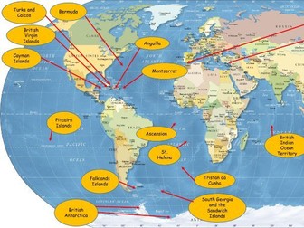
I have created this and put this up in my classroom to show students where Britain can be found around the world. It briefly explains the reasons as to why these places exist (colonialism). This links to history and anthropology. These could also be used in lessons as a filler lesson in between Schemes of Work or if you just wanted to come off the Scheme of Work for a lesson or two (providing you have created or found resources in addition). Each territory is linked to a geographical location (which is provided). Turks and Caicos Anguilla Virgin Islands Cayman Islands Gibraltar Bermuda Montserrat Falklands Islands South Georgia and the Sandwich Islands Tristan da Cunha St. Helens Ascension British Indian Ocean Territory Pitcairn Islands Akrotiri and Dhekelia British Antarctica
Country information sheetsQuick View
CreolaCreola

Country information sheets

(0)
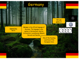
This resource can be used for you to create questions for students to look for the answers. This can be used on a carousel for learning or a treasure hunt around your department or school. There is a “can you guess…?” challenge on each page with something that relates to that country. For instance there are three German car brands on the Germany page. Some students may know what these are and some may not so you can allow them to investigate.
French territories/Les territoires français Top TrumpsQuick View
CreolaCreola

French territories/Les territoires français Top Trumps

(0)
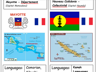
These Top Trumps can be used in Geography, French and History. There are 10 cards with one card that has two territories. These top trumps were created to introduce students to parts of the world that they may have never heard of and to practice key geographical language such as “population” and “GDP Per Capita”. Each trump will have a map, a flag of the territory, a flag of France, languages that the territory speaks, GDP Per Capita, land mass size, population and distance from Paris. Guadeloupe Martinique French Guiana St. Martin and St. Barthelemy (together) La Réunion Mayotte New Caledonia French Polynesia Wallis and Futuna St. Pierre and Miquelon If students want to know the capital of each territory get them to refer to the title of each trump.