 Quick View
Blank & Colored United States Map with and without State Names
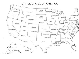
This resource includes three images of a map of the United States, ideal for classroom display and student reference. The maps can be used to support learning in Geography, Social Studies, and History, helping students become familiar with U.S. states and locations.
I have included:
Blank map of the USA
Blank map with state names
Colored map with state abbreviations
These are perfect for:
Labelling activities
Introductions to U.S. geography
Class discussions and presentations
Worksheets, quizzes, or revision tasks
The images are simple and versatile, making them suitable for elementary and middle school learners. They can be printed or used digitally on interactive whiteboards or devices.