A simple schematic model from the British Geological Survey of the Eyjafjallajökull volcano summit, crater and ash plume, Iceland, as seen on Blue Peter’s Make It. It is intended as a simple guide to understanding how volcanoes such as Eyjafjallajökull are influenced by tectonic plate activity along the Mid-Atlantic Ridge. It also shows the route of the floodwater from melted glacier ice to the sea. The height of the volcano is highly exaggerated.
Requires scissors and glue.
For more geoscience information and resources for learners visit Discovering Geology from the British Geological Survey https://www.bgs.ac.uk/discovering-geology/
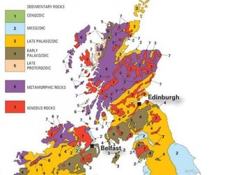
This colour-in geology map of the UK and Ireland is a useful teaching aid to learn more about the age, composition and distribution of the rocks across the British Isles.
You can also use this geological map to help you learn when the sedimentary rocks of the UK and Ireland were formed.
Turn over the map to show how the eras are made up of Periods. The Periods are the basic unit of geological time and are separated by a major geological event such as a mass extinction.
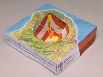
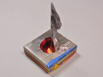
The Soufrière Hills Volcano on the Caribbean island of Montserrat began erupting in 1995 and, in June 1997. Pyroclastic flows claimed the lives of 19 people and led to two-thirds of the population fleeing the island.
This model (not to scale) from the British Geological Survey shows how the volcano is formed from the subducting tectonic plates, and the lava dome with a pyroclastic flow coming from it.
Requires glue and scissors.
For more geoscience information and resources for learners visit Discovering Geology from the British Geological Survey https://www.bgs.ac.uk/discovering-geology/
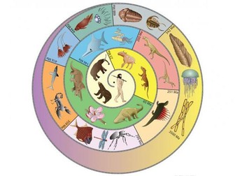
The spiral timeline illustrates some of the animals and plants that have lived at different periods in Earth’s history, from the earliest life to human beings.
Downlad, print and cut out the sprial timeline and hang from the ceiling.
Avaiable in full colour or in black and white for you to colour in.
For more geoscience information and resources for learners visit Discovering Geology from the British Geological Survey https://www.bgs.ac.uk/discovering-geology/
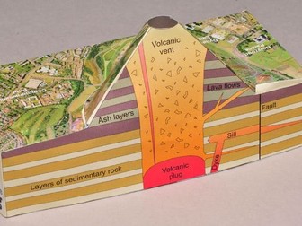
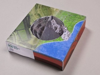
A simple schematic model from the British Geological Survey of Arthur’s Seat showing how the rocks formed from a volcano similar to the modern-day Soufrière Hills volcano, Montserrat in the West Indies.
This model is intended to aid understanding of where such volcanoes form and how volcanic rocks can be important natural resources for construction.
Requires scissors and glue.
For more geoscience information and resources for learners visit Discovering Geology from the British Geological Survey https://www.bgs.ac.uk/discovering-geology/
A simple schematic model of Bardon Hill Quarry from the British Geological Survey showing how the rocks formed from a volcano similar to the modern-day Soufrière Hills volcano, Montserrat in the West Indies. This model is intended to aid understanding of where such volcanoes form and how volcanic rocks can be important natural resources for construction. Volcanic rocks from Bardon Hill Quarry are extracted, crushed and used for building schools, roads and houses. The volcano that deposited the Bardon Hill rocks would have been much larger than the diameter of the quarry.
Requires scissors and glue.
For more geoscience information and resources for learners visit Discovering Geology from the British Geological Survey https://www.bgs.ac.uk/discovering-geology/
Earth’s climate has changed throughout the billions of years of our planet’s geological history. Evidence for past climate, including the extreme conditions linked to mass extinctions, can be found in the rocks around us. Many rock-forming environments are directly influenced by climate. Were your local rocks formed in a desert, or a tropical swamp, or on a cold seabed? And what evidence can we find to show that these environments really existed millions of years ago?
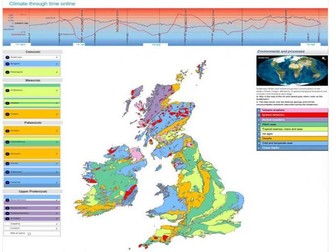
The Climate through time poster, worksheet and online map illustrate the links between our planet’s changing climate and the different rocks that formed as environmental conditions varied through geological time.
Climate through time online is an interactive version of the popular poster map, but includes examples of where you might find some of the rock types in the UK and Ireland. https://www2.bgs.ac.uk/discoveringgeology/climate-change/climate-through-time/map.html?_ga=2.72290836.627011873.1660216405-592377844.1660216405
You can show the different rock-forming environments and processes by either clicking on the geological time Period menu or the sea level/temperature graph. This will change the map of the UK and Ireland to show just the rocks formed during that period:
Click on the palaeogeographic globes to show the approximate position of UK and Ireland during that period.
Click on the ‘Environment and processes’ tabs to show the evidence and examples of where the rocks outcrop at the surface.
Look at the temperature and sea level curve during that period. Where was the UK and Ireland at that time, nearer to the equator or the South Pole?
Click on the ‘Save and print’ button at the bottom of the map to print a map of individual periods.
For more geoscience information and resources for learners visit Discovering Geology from the British Geological Survey https://www.bgs.ac.uk/discovering-geology/
Download and print this simple paper Tyrannosaurus rex puppet.
You will need some glue, scissors and paper fasteners to join the parts of the jaw together. It is a useful 20-minute extension activity that could be used when discussing dinosaurs or geological time periods.
This Minecraft World uses the classic geological study area of Ingleborough as an introduction to 3D geological models.
Fly over the geological map at the surface or dig below ground to expose the of the limestone landscape beneath Ingleborough.
Installation:
Download the Zip file
Unzip the archive to a temporary location
Start Minecraft
On the home screen click ‘Options’
Click ‘Resource Packs’
Click ‘Open resource pack folder’. This will open a new window showing the contents of your Minecraft ‘Resource packs’ folder
Navigate to the folder above (called .minecraft on Windows)
Open the ‘Saves’ folder
Move the unzipped archive to this ‘Saves’ folder
Start Minecraft and select ‘Single player’. When prompted to select a world, choose BGS GB geology with OS
For more geoscience information and resources for learners visit Discovering Geology from the British Geological Survey https://www.bgs.ac.uk/discovering-geology/
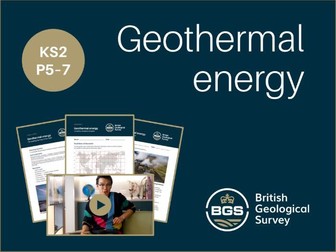
Complete lesson plan with video and worksheets designed to support an interdisciplinary lesson on geothermal energy for 7-11 year olds.
Includes a teachers guide, introductory video, three worksheets and a class certificate.
Outline:
To investigate the geological conditions required to harness geothermal energy in the UK.
Activities:
• Video introduction to geothermal energy in the context of the Earth’s renewable and non-renewable energy resources
• Mapping locations using two-figure grid references
• Drawing bar chart comparing geothermal energy in different counties
• Reviewing case study of a geothermal power station
Curriculum links:
National Curriculum > Key stage 2 > Geography > Human and physical geography
Curriculum for Excellence > Second level > Science > Planet Earth > Energy sources and sustainability
For more geoscience information and resources for learners visit Discovering Geology from the British Geological Survey https://www.bgs.ac.uk/discovering-geology/
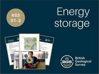
Energy storage: how geology can help to balance supply and demand. A complete lesson on the topic of energy storage with video, worksheets and class certificate.
Outline:
To investigate how renewable energy can be stored, using the context of home heating.
Activities:
• Video introduction to large-scale energy storage as a solution to the challenges of balancing the UK’s energy demand with the variable and intermittent supply from renewable energy resources
• Drawing and analysing bar chart of temperature data
• Mapping locations using six-figure grid references
• Interviewing a family member about home heating systems
Curriculum links:
National Curriculum > Key stage 3 > Geography > Human and physical geography
Curriculum for Excellence > Third level > Science > Planet Earth > Energy sources and sustainability
For more geoscience information and resources for learners visit Discovering Geology from the British Geological Survey https://www.bgs.ac.uk/discovering-geology/
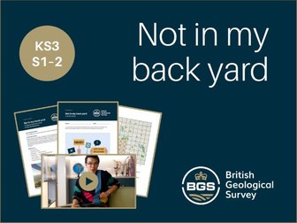
A complete lesson on the topic of energy infrastructure placement with video, worksheets and class certificate.
Outline:
To investigate and discuss the placement of energy infrastructure.
Activities:
• Video introduction to the concept of the 3 As that can be asked when examining the development of the Earth’s energy resources: accessibility, availability and acceptability
• Ranking of hypothetical developments from pupils’ homes
• Group discussion about hypothetical energy developments
• Mapping locations using four-figure grid references
Curriculum links:
National Curriculum > Key stage 3 > Geography > Human and physical geography
Curriculum for Excellence > Third level > Science > Planet Earth > Energy sources and sustainability
For more geoscience information and resources for learners visit Discovering Geology from the British Geological Survey https://www.bgs.ac.uk/discovering-geology/
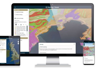
The BGS Geology Viewer is a free app available on all browsers that lets you access detailed information about the geology all around you. Tapping the map reveals the bedrock and superficial geology as well as explaining how certain features were formed.
https://geologyviewer.bgs.ac.uk/
Features:
3D Visualisation – View BGS Geology data draped over a 3D terrain model to get a new perspective on the geology of Great Britain.
Multiple base maps – View the BGS Geology data over a choice of base map, including satellite imagery.
Geolocation – Use your device’s GPS to track your position on the map while you explore.
Dynamic geology legend – Pan around the map and you can see the geology legend update to show all visible formations. To view, open the sidebar and tap ‘View the layer legend’ button. Clicking a legend item will take you to the BGS Lexicon for the full details.
Add to Home Screen – BGS Geology Viewer can be installed onto your mobile home screen.
 Quick View