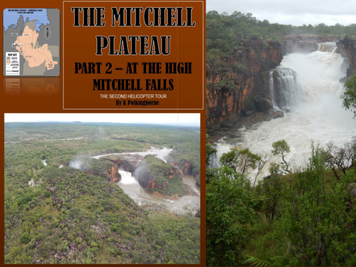


This follows on from the introductory unit by examining - mainly from the air- the landform feature of the Mitchell Plateau during an extremely wet February (wet season month) when the only access to the area is via air. The role of water in the construction of the sedimentary sandstone plateau is explained . The role of water is very evident in the destruction processes operating on the Plateau. There are 8 attachment pages (4 colour/4 black and white for you to chose). These attachments range from questions to photograph/diagram interpretation activities. Join the helicopter adventure and fly over this remote wilderness area. You will see it as its most spectacular. You won't be disappointed. This unit touches a range of issues in physical geography - such as - weathering, erosion, river load transfer, and climate change. It also provides a background to unit 4 in the series when Conservation issues have a focus. In terms of curriculum this unit relates to UK Curriculum Key Stages 2 and 3 Human and physical geography - rivers, mountains, rocks and structure, climate change and geological time scale. In the Australian curriculum it relates to senior geography in terms of the evolution of landforms and geomorphology. It has relevance for Year 8 and Year 10 studies in river, inland water and land formation studies. Or - at a basic level you could just take your students on the helicopter flight to experience the area. Put on your wet weather gear and enjoy the adventure.
Something went wrong, please try again later.
This resource hasn't been reviewed yet
To ensure quality for our reviews, only customers who have downloaded this resource can review it
Report this resourceto let us know if it violates our terms and conditions.
Our customer service team will review your report and will be in touch.
£0.00