

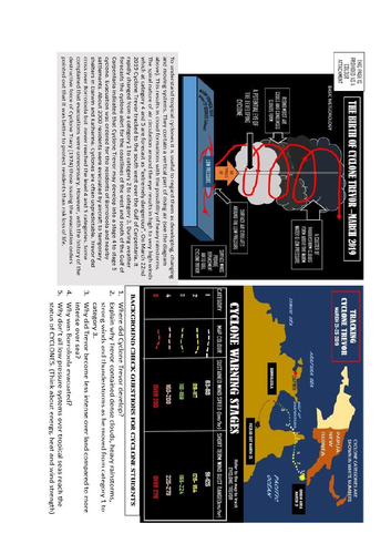
Tropical cyclones are not unusual events along the northern tropics of Australia. They originate in warm tropical seas and gain interest (and names) when they track across coastal areas. Trevor followed this trend. You students can track Trevor’s pathway. The inclusion of the cyclone diagram will help your students understand why the downpours and high winds generated in cyclones make them potentially dangerous for those living in their pathways. Cyclone Tracy passed over Darwin and caused loss of life and widespread damage. Most residents of Darwin had to be evacuated after the cyclone so that the city could be repaired. The lessons from Tracy were twofold. Rebuild stronger cyclone-proof houses and provide a cyclone warning system for those potentially in the pathway of an approaching cyclone. In the case of a category 4 or above cyclone evacuation was recommended. Trevor crossed the west coast of the Cape York Peninsula and tracked south west across the Gulf Of Carpentaria. As anticipated, Trevor built up wind speed and rainfall intensity as he headed towards the coastline. As he approached the coastline Trevor had reached Category 3. With the anticipation that Trevor would reach Category 4 (an extreme danger level) the Department of Meteorology
issued its cyclone alert and evacuation of Borroloola and nearby settlements were ordered. Trevor proved to be unpredictable. He did pass over Borroloola. He did bring strong winds and heavy showers. However, Trevor did not reach category 4. He tracked eastward over inland Queensland dropping heavy showers on the headwaters of the Thomson and Barcoo Rivers. Replenished the Thomson and Barcoo Rivers provided water flows into the northern perimeter of the Lake Eyre Basin. These rivers flow into Cooper Creek which, if it receives enough flow empty into Lake Eyre. Why relate all this? Well it explains the idea of “the mixed blessings of Trevor”. Some returning residents of Borroloola were a bit miffed at an evacuation that they regarded as unnecessary. They were literally put out. Along the Cooper Creek the water provided by Trevor began flowing into the many channels of the Channel Country. They were being rescued from 4 years of drought and the water inundation would provide the growth of pasture feed for their cattle. Taken in the broader view, Cyclone Trevor had proved to be a mixed blessing. Time will tell if there is sufficient water in Cooper Creek to join the flows from the Diamantina seeping into Lake Eyre (March-May 2019). The attachment sheets are provided so that hard copies can be distributed. This could be a standalone interest unit. It also links with the floods affecting cattle producers and Townsville. A unit of the Lake Eyre flood is in the process of development.
Something went wrong, please try again later.
This resource hasn't been reviewed yet
To ensure quality for our reviews, only customers who have downloaded this resource can review it
Report this resourceto let us know if it violates our terms and conditions.
Our customer service team will review your report and will be in touch.
£0.00