
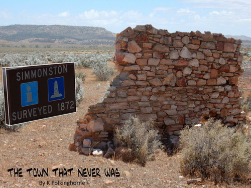
In the study of urban places there is often a focus on why certain locations have been chosen for a settlement. This study on Simmonston in the Flinders Ranges reverses this approach by looking at the reasons for choosing a location for a town but then discovering why it never developed beyond two buildings which now lie as ruins in the landscape. This study has a focus on a place well north of Goyder's Line. It is quite probable that Goyder (see the unit on Goyder's Line) rode through this area in 1864 when gaining evidence about the condition of pastoral leases and rent relief. This is typical salt bush country which Goyder designated as pastoral land. Simmonston, like Bruce (Willochra study) was part of the enthusiasm for town and possibly farming expansion north. Simmonston missed out on the Great Northern Railway route and the town never developed . This unit links history, environment, railway route decision, geography with the evidence lying as ruins in the landscape. It stands alone or it can be linked with other units on the Flinders Ranges such as the rise and fall of Kanyaka Station, Goyder's Line,The abandoned settlement of Bruce on the Willochra Plains, the day the railway bridge disappeared. You can use this as a simple see and understand unit at junior levels or as a link with more detailed studies at a more senior level on the Flinders Ranges of South Australia. If you like, you can come and observe the proposed town site to discover what's there and what is not there, which is just about everything.
Something went wrong, please try again later.
This resource hasn't been reviewed yet
To ensure quality for our reviews, only customers who have downloaded this resource can review it
Report this resourceto let us know if it violates our terms and conditions.
Our customer service team will review your report and will be in touch.
£0.00