
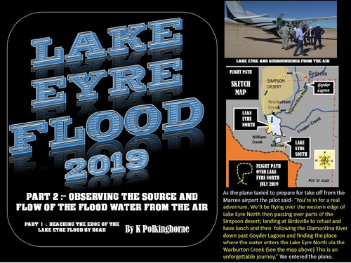
This is a very special unit which has a focus on an event that only happens occasionally. However, you’re in luck because during 2019 enough flood waters from hundreds of kilometres north flowed into the Lake Eyre North depression. In Part 1 of this series the shores of Lake Eyre North were reached by road. In this unit your students can experience the flood from the air. Now they can gain some understanding of the size of the Lake Eyre North depression within an extremely arid landscape. For junior students the photographs alone will provide an interesting resource in a “what is it like” approach. For students studying rivers and inland water systems this provides details about Australia’s largest inland drainage basin and intermittent lake. Fly over part of the Simpson Desert. Land at Birdsville where part of the town was flooded in late February. Then follow the Diamantina River through the unique Goyder Lagoon and trace the flow through the Warburton Creek into the Northern edge of the Lake Eyre North. You’r too late to see the yachts from the Lake Eyre Yacht Club sialing on the Warburton Creek. Trace the water flow down the Warburton Groove to reach the lowest point in Australia in Bell Bay (15.2 metres below sea level). If you wanted to see Lake Eyre South in flood your in for a minor disappointment because this flood will not provide enough water to reach the 4.2 metre depth which activate water flow between Lake Eyre North and Lake Eyre South via the Goyder Channel. By looking at the maps and the selection of photographs your students should be able to gain an understanding of the hydrology (water source and flows) of the flood. Their understanding will be tested in the attachment sheets which provide an opportunity to select, cut and paste photographs and maps into their written answers. So journey into the Australian outback, gain a feeling for the climatic and physical environment and join the unforgettable adventure of seeing Lake Eyre in flood. Don’t delay too long because Lake Eyre North will soon return to its normal state - a dry sand or salt depression.
Something went wrong, please try again later.
This resource hasn't been reviewed yet
To ensure quality for our reviews, only customers who have downloaded this resource can review it
Report this resourceto let us know if it violates our terms and conditions.
Our customer service team will review your report and will be in touch.
£0.00