
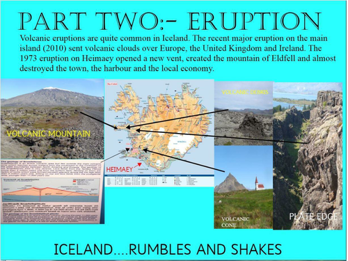
How do you cope with a volcanic eruption within a few hundred metres of your home? The people of the island of Heimaey had to find the answer. Heimaey is a small volcanic island off the coast of Iceland. In 1973 the Eldfell Volcano erupted and volcanic material (ash and lava) spread over the town.This 1973 eruption is analysed by map to show the extent of the lava flows and the threat to the human population. The settlers on the island had to undergo evacuation. By looking at the map you can recognise the threat the advancing lava flow cause to the town and, more significantly, to the harbour. This harbour was vital to the main activity of the island - fishing. This is the first of a 3 part series which has a focus on this island. It begins with eruption and evacuation. It continues with actions to save the harbour and the fishing activity (Part 2) and then looks at present day Heimaey in terms of the growth of the fishing activity and the role of tourism. Join in its explosive history and its recovery from near disaster. These units could be used from Upper Primary to mid-Secondary levels.
Something went wrong, please try again later.
This resource hasn't been reviewed yet
To ensure quality for our reviews, only customers who have downloaded this resource can review it
Report this resourceto let us know if it violates our terms and conditions.
Our customer service team will review your report and will be in touch.
£0.00