 Quick View
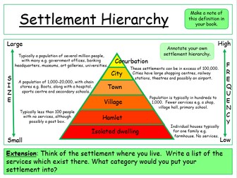
Settlement Hierarchy
• READY TO TEACH (LESSON 2/14 - WORLD CITIES).
In reference to the new KS3 AQA textbook (although not necessarily needed, as all information required for the lesson is included within the resources).
Pupils sketch and label the three settlement patterns. Pupils make a note of the key definition of the lesson in their book, linked to the learning objective. Pupils spend time annotating their settlement hierarchy model. Explain each settlement size in terms of population and services found. An extension task is included for pupils to transfer the model into an existing settlement - does it fit? You may wish at this point of the lesson to discuss the limitations associated with the settlement hierarchy model. As a mini-plenary, ask pupils to identify the settlement size, from the image displayed on the whiteboard (slides 4-14). The homework task involves identifying a range of settlement sizes in the UK (pupils must present homework next lesson for self-assessment). A quick Blockbusters quiz to summarise the key terms discussed this lesson is included as a plenary (slide 16).