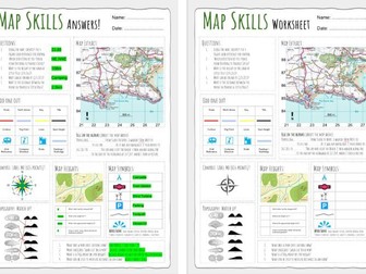
Up to date worksheet for map skills for any Geography curriculum and Key Stage.
Includes:
4fig grid references
6fig grid references
direction
compass
scale
map symbols
and more
This work booklet guides pupils through vital mapping skills by giving them a ‘how to guide’ as well as a chance to practise their new skills in a variety of questions and tasks. The booklet is aimed at children in upper KS2 and lower KS3 and can be easily adapted to suit. The booklet can be given at the end of a unit of work or spread out across several lessons.
The mapping skills included in this work booklet include:
4 Figure Grid References
6 Figure Grid References
Compass Directions
Contour Lines
Calculating Scale
Each topic above includes a one-page ‘how to guide’ and well as a corresponding 'activity sheet.'
Download is in pdf format.
Are you ready to turn this holiday season into a global adventure for your young explorers? Introducing our enchanting Christmas-themed geography map skills activity booklet, specially crafted for curious minds aged 10-14!
Festive Learning Fun: Transform geography lessons into a holiday celebration! Each activity is designed to weave Christmas magic into essential map skills, making learning both educational and joyous.
Engaging and Age-Appropriate: Tailored for 9-12 year olds, our activities strike the perfect balance between challenge and entertainment. Watch as your child hones their map-reading skills while embracing the holiday spirit.
Santa’s Global Adventure: Follow Santa’s journey around the world! From the North Pole to bustling cities and exotic landmarks, each activity unveils a new destination, fostering cultural awareness and geographical knowledge.
Map Skills Included:
Grid References
Scale & Distance
Compass Directions
Contour Lines
Time Zones
A total of 14 activity pages with answers included.
Photocopiable handout that introduces students to the various landforms that can be identified on a topographic map using the arrangement of contour lines.
Also available in a bundle of all topographic mapping skills plus 10 graded exercises (with answers) at this link:https://www.tes.com/teaching-resource/topographic-map-skills-11564811
An end of unit test for year 7.
Includes all major map skills such as compass points, grid references, scale, longitude/latitude and relief. Also includes mark scheme, self reflection sheet and differentiated. DIRT tasks require foundations textbook or could be adapted to suit.
This resource has been designed for Entry Level 3 students working towards Functional Skills Maths qualifications at Level 1 (Edexcel-Pearson, NCFE, City and Guilds, AQA, Highfield Qualifications, NOCN, Open Awards). It contains an age-appropriate, 70-slide PowerPoint lesson on maps and scales.
The resource will help pupils to achieve these outcomes:
convert between scale and real life measurements
calculate the real life measurements of scale drawings
calculate the distance between places on a map using a scale
find the bearings between places on a map
The PowerPoint clearly explains how to convert between scale and real life measurements and how to find the distances and bearings between places on maps. It is ideal for introducing the maps and scales component of the specification and for revision purposes.
Please note, the watermark on the preview images is not present on the resource itself.
You may also be interested in:
Level 1 - Maps and Scales - 28 Page Workbook
The 28-page workbook contains 12 explanation pages, 13 worksheets, 2 progress checks and a certificate of achievement. It is provided in PDF and an editable PowerPoint version. It can be used for classwork, homework, revision or as an independent learning pack.
Save money and buy both resources at a discounted rate:
Level 1 - Maps and Scales - PowerPoint Lesson and Workbook
The bundles below contain workbooks and PowerPoint lessons that cover all of the outcomes at each level.
Level 1 - Measures, Shape and Space Bundle
Level 1 - Numbers and The Number System 10 Workbooks - 10 PowerPoints
Entry 3 - 16 Workbooks - 16 PowerPoints
Entry 2 - 13 Workbooks - 13 PowerPoints
Entry 1 - 11 Workbooks - 11 PowerPoints
More Functional Skills Maths Resources
Entry Level English Resources
Map Skills Homework 5 - OS Maps
4 and 6 Figure Grid References using an OS Map
As part of the Map Skills Homework Bundle with 4 other worksheets
Can be used as a worksheet in lesson
Full unit of work for map and graph skills. All lessons are fully resourced. Lessons are designed to last for 50-60 minutes. Lessons are resourced with videos, extension questioning, deep thinking and uses graphs/images to aid learning.
These lessons follow the Oxford KS3 curriculum and look at;
Continents & Countries
Map Skills
Directions
Distance & Scale
Grid References
Longitude & Latitude
Height
OS Symbols
Graph Skills
Each lesson includes a starter, lesson objective, plenary and various student led activities.
If you liked this resource please check out my other resources at https://www.tes.com/teaching-resources/shop/SimpleGeography
All resources required for lesson are attached.
The lesson provides scope for AFL and is fully differentiated.
Objectives for lesson:
- Explain what scale is
- Use scale to measure distance on a map
- Label the key cities in the UK
KS3 Geography Map Skills Topic suitable for Year 7 - Good Introduction Topic.
Fully resourced including Assessments, PowerPoints and Booklet
Content Covered:
Latitude and Longitude
Compass Points
Grid References
Scale
Relief
Continents/Countries
This Map Skill lesson reviews all on the previous Map Skills lessons and test the students skills with increasing difficulty. This lesson reviews all the maps skills covered in the first 5 lessons - Map Symbols, 4 & 6 figure grid references, height, scale and distance
In addition to the lesson you will require an Ordnance Survey Map.
It contains:
Three levels of differentiation
Starter and plenary
Printable resource
A map skills homework booklet for use with KS3 Geography classes.
An amalgamation of worksheets I have gathered over the years to create a comprehensive and easy to mark Map Skills Homework Booklet!
Here is a bundle of fully resourced map skills worksheets ideal for recapping, revising or challenges a students map skills. They are designed for KS3/4 but have been used as a refresher for A-Level.
This bundle includes all answer sheets and resources with well designed student friendly images.
Assessing compass directions, measuring distance, grid references, map symbols, contour lines and describing directions, this workbook is a great revision tool for geographers of any age wanting to hone their OS map skills.
Entire lesson focusing on knowledge of coasts and applying it to map skills- grid references and identifying landforms on an OS map. Ideal for GCSE revision.
Full unit of work for map skills and the UK. This unit explores compass points, 4 and 6 figure grid references, scale, distance, longitude, latitude and other core map skills, alongside the UK. All lessons are suitable for 50 minutes to 1 hour of teaching time. Includes supporting worksheets for lessons - no additional resources are required. Most suitable for KS2, years 5 or 6.
All lessons have a starter and lesson aim. All PowerPoints in the same signature style.
Lesson sequence:
1 – Introducing maps
2 – Where is the UK?
3 – Compass points
4 – Map symbols
5 – 4 and 6 figure grid references
6 – Scale and distance
7 – Atlas skills
8 – Longitude and latitude
9 – Design a treasure map
10 – ICT Mapzone
11 – UK and Europe flags
12 – Migration
13 – Human vs physical features
Also includes Geography Literacy mat and Geography Numeracy/Map Skills mat, as well as an extension sheet pack with homework’s and activities to extend pupil skills and knowledge.
Links to National Curriculum:
- Locate the world’s countries, using maps to focus on Europe (including the location of Russia) and North and South America, concentrating on their environmental regions, key physical and human characteristics, countries, and major cities
- Name and locate counties and cities of the United Kingdom, geographical regions and their identifying human and physical characteristics, key topographical features (including hills, mountains, coasts and rivers), and land-use patterns; and understand how some of these aspects have changed over time
- Identify the position and significance of latitude, longitude, Equator, Northern Hemisphere, Southern Hemisphere, the Tropics of Cancer and Capricorn, Arctic and Antarctic Circle, the Prime/Greenwich Meridian and time zones (including day and night)
A set of photocopiable masters that takes students through the basic skills involved in reading topographic maps including:
1. Introduction and marginal information
2. Symbols and colours
3. Map direction and bearings
4. Height and slope
5. Landforms
6. Area reference and grid reference
7. Scale
8. Measuring distance
9. Measuring area
10. Constructing cross-sections
11. Gradient
The bundle also includes a series of ten graded topographic maps and exercises which increase in level of difficulty as students progress through them. Answers are provided for all ten of the topographic map exercises.
This map skills lesson is about map symbols. It is suitable for key stage 2 and 3 and takes 50 mins to 1 hour. The lesson includes some creative writing where students substitute words for map symbols. Within the presentation are all the printable material to support this lesson
It contains:
Three Three levels of differentiation
Starter and plenary
Printable material
Engaging game activity
Printable resource
A complete geography skills bundle containing four lessons designed for the end of Year 9 once main content has been completed. These lessons have also been used successfully with Year 8 cover groups and would be useful for low ability GCSE Geography intervention or revision sessions.
This bundle focuses on key geographical skills that students often need extra practice with. It includes work on four figure grid references, six figure grid references, coordinates, mean, mode, median, range, scatter graphs, map reading, graph paper, relief and interpreting geographical information from maps and diagrams.
The lessons are structured to support independent work, cover lessons, revision sessions and intervention groups. Tasks are clear and accessible, making them suitable for non specialist cover as well as normal classroom teaching.
Included in the bundle are PowerPoint lessons and supporting printable resources. The activities help students build confidence with geographical skills step by step and provide useful practice for KS3 Geography and GCSE Geography preparation.
Suitable for Year 8 Geography, Year 9 Geography, KS3 Geography, GCSE Geography intervention, low ability GCSE support, AQA Geography skills practice, cover lessons and end of year geography lessons.
 Quick View
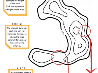 Quick View
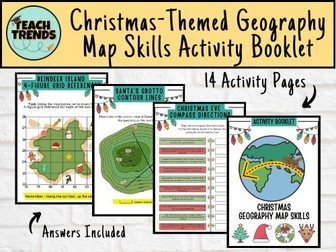 Quick View
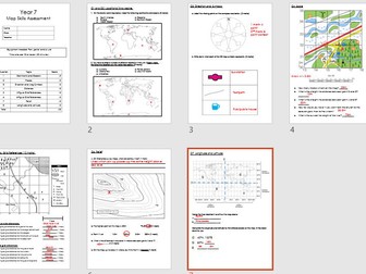 Quick View
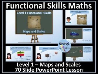 Quick View
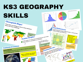 Quick View
 Quick View
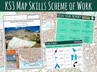 Quick View
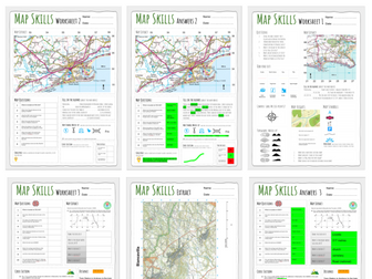 Quick View
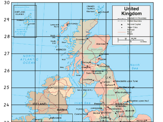 Quick View
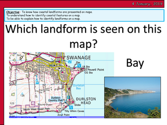 Quick View
 Quick View
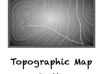 Quick View
 Quick View