

404Uploads
1039k+Views
670k+Downloads
Geography
KS2 Geography: Weather and climate zones around the world topic - powerpoints and activities
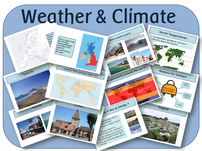
A set of resources looking at holidays and world climate zones. It contains 5 PowerPoint lessons to use on an interactive whiteboard, and 4 pdf activities to print out.
POWERPOINTS:
Holidays: Where have we been on holiday; why do people go on holiday, with photo prompts, maps and explanations
World Climates: Description of Tropical, Temperate and Polar climates, where they are in the world, and a brief explanation why.
Planning a holiday: Description of 4 people to plan a holiday for. Links to online resources.
Country Research: Links to good websites for the children to research.
What do we need to pack: 4 locations for the children to look at and pack for.
PDF FILES
My packing list - to fit in with the PowerPoint file.
Printable world map - for the children to plan their holiday route.
Postcard - Blank postcard for the children to write.
Passport of places visited - for the children to fill in at the end of the topic.

Geography topic: Coasts - powerpoint lessons and activities
A set of lessons and worksheets looking at coasts, erosion, deposition and tourism.
POWERPOINTS
INTRODUCING COASTS:
Introduction to what coasts are; erosion and deposition, and investigating different coastal localities around the UK.
COASTAL EROSION:
Looks at different physical features caused by wave erosion - arches, caves and coastal stacks, and demonstrates the process of erosion by animated diagrams of how each feature is formed. It also briefly explains how different rock types erode at different rates, and shows a map of the UK, with the main types of rock found in each area. It ends with a series of photographs for the children to look at and identify coastal features.
COASTAL DEPOSITION:
Investigates the process of longshore drift, with an animated example, and explains the difference between sand and shingle beaches.
INVESTIGATING COASTAL ENVIRONMENTS:
Gives the children the task of writing a piece about a different coastal location for a holiday brochure.
MANAGING THE COASTLINE:
Explores how coastal erosion affects humans, and the reasons why we need to protect the coast from erosion. It explains how we protect the coast by building groynes, sea walls, armour, artificial harbours, or how we can just do nothing - giving the advantages and disadvantages of each method of protection.
COASTAL DEVELOPMENT:
Gives the children the task of being a local resident, a sea angler, a travel company representative, a holidaymaker, or a local government official, and deciding whether a hotel should be built in an unspoilt area of coastline.
WORKSHEETS (PDF)
LABEL COASTAL AREAS ON UK MAP: A blank UK map for the children to identify coastal areas that they know.
COASTAL EROSION: 2 pictures of coastal erosion for children to name features and describe the formation
WORLD AND UK MAP: To locate coastal areas in the world that they have visited
BROCHURE TEMPLATES: 10 different blank layouts for the children to fill in for the holiday brochure.
COASTAL DEVELOPMENT GROUP WORKSHEETS: Recording sheets when the children split into different groups to decide on whether a hotel should be built.

Africa - Botswana - Gweta powerpoints & activities
A set of lessons investigating different aspects of Geography in Gweta / Botswana:
POWERPOINTS
AFRICA - LOCATION IN THE WORLD:
Looks at the location of Africa in relation to the UK, and the rest of the world. It names the continents and oceans of the world, and places in Africa the children may be familiar with. It ends with an interactive quiz on the continents and oceans.
BOTSWANA - LANDSCAPE:
Looks at the topography of Botswana, and different landforms - the Kalahari Desert, the Okavango Delta, the Makgadikgadi Pans; rivers, and savannah.
BOTSWANA - CLIMATE:
Explains how Botswana is located in the tropics, and how this affects the climate. It shows average minimum and maximum monthly temperatures, and average monthly rainfall totals
BOTSWANA - ENVIRONMENTAL ISSUES:
Looks at the main problems facing Botswana - drought and desertification, and the solutions underway.
BOTSWANA - PARKS AND RESERVES:
The Chobe National Park, the Nxai Pan National Park, and the Central Kalahari Game Reserve.
BOTSWANA - FACTS AND INFORMATION:
Looks at the history of Botswana, agriculture, food, school, crafts, and homes, plus fast facts about the flag, coat of arms, population, capital city, borders, currency, language, and religion.
GWETA AND BOTSWANA - NATURAL RESOURCES:
Investigates diamond mining, agriculture, and crafts, with a look at teh Gweta Natural Resources Trust and how they are supporting local villages.
GWETA - WHAT IS IT LIKE?:
Shows the location of Gweta, with lots of pictures to study.
WORKSHEETS (PDF)
AFRICA MIND MAP - to find out what the children already know
ROUTE PLANNING - a blank world map for the children to plan their route from home.
TEMPERATURE AND RAINFALL GRAPHS - For the children to study and answer questions.
TEMPERATURE AND RAINFALL GRIDS - For the children to convert into graphs.