I currently work at the top end of Primary school in Year 5/6. I create resources for a range of subjects and am always open to suggestions for resources people require.
I currently work at the top end of Primary school in Year 5/6. I create resources for a range of subjects and am always open to suggestions for resources people require.
The eighth of a ten part series of lessons that focus on many of the elements of the locational knowledge aspects for the KS2 Geography curriculum. The series of lessons focuses predominantly on children being able to use maps to find countries and cities in different continents as well as a brief focus on time zones and globalisation. All of the resources needed to run the lesson are included with worksheets, any potential example maps required (in case atlases are unavailable) the presentation and unit of work plan.
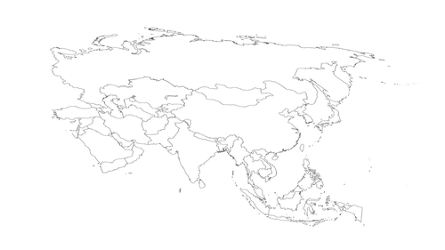
This lesson focuses on being able to identify various Asian countries and their capital cities and labelling these via a blank map.
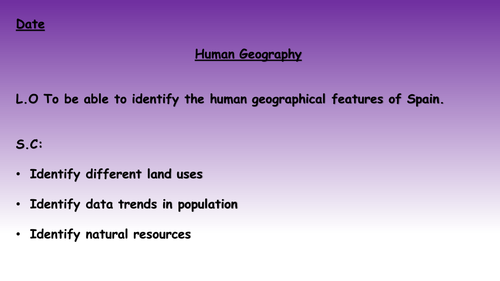
Two lessons to focus on the physical and human geography of Spain.
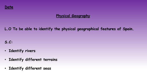
Lesson 1 (titled Lesson 4) - A lesson that focuses on the physical geography of Spain, including looking at the rivers, seas and terrain. All the resources that are needed to run the lesson are here including differentiated worksheets, the presentation and maps that can be used if you don't have access to atlases etc.
Lesson 2 (titled Lesson 5) - A lesson that focuses on the human geography of Spain, including looking at population trends, average life expectancy and land use. All the resources that are needed to run the lesson are here including differentiated worksheets, the presentation and maps that can be used if you don't have access to atlases etc.
N.B They are titled differently to their actual lesson numbers as they form part of a bigger unit of work.
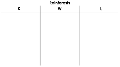
The final three lessons in a sequence of twelve lessons that focuses on researching and writing an information text about the Amazon Rainforest. Included is the unit plan, a KWL sheet that can be used to check and develop understanding, the lesson presentation which includes pink and green bubbles to support and challenge and activities required for the lesson as well as a fact file.
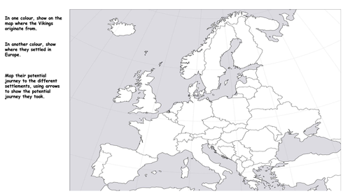
A blank map activity that can be used to get children to show where Vikings originate from as well as where they settled. Children can then map out the potential journey the Vikings took to get to the various places through the use of arrows. Included is a map of Europe showing where the Vikings settled and raided to support children.
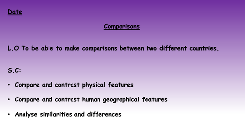
A lesson that focuses on comparing and contrasting physical and human geographical features between the United Kingdom and Canada. Each slide has a map of Canada and of the U.K for a particular feature with the class then spending time noting down similarities and differences. These can then be discussed as a class before moving on to the next slide.
A simple knowledge organiser for a topic on rainforests. Included is an image of a potential example one, some important vocabulary, a map of the world showing where all the rainforests are and a map showing biodiversity.
A lesson that focuses on the human geography of Spain, including looking at population trends, average life expectancy and land use. All the resources that are needed to run the lesson are here including differentiated worksheets, the presentation and maps that can be used if you don't have access to atlases etc.
A variety of pages that can be used to support pupils with activities linked to maps of Europe, including quizzing and recall of countries in Europe and where they are on a map or being able to label different countries using a map to support.
The resource includes:
A blank map of Europe with country borders set out that can be used for a range of activities
A black and white labelled map of Europe
A black and white labelled map of Europe with 2 on a page to save printing
A coloured labelled map of Europe
A coloured labelled map of Europe with 2 on a page to save printing
A map activity with 30 countries numbered to then label around the outside
Answers to the map activity
A lesson that focuses on world maps, looking at continents and oceans before focusing in on five of the continents and discussing some of the countries that are included within each of the continents.
The lesson can be used as a general introduction lesson or as a recap lesson at the start of a new year to ensure children know some basic information around continents and oceans. There are general check points to keep quizzing and an activity linked to naming the continents and oceans.
For those in the U.K, there are then three slides that follow the activity looking at the difference between Great Britain and the United Kingdom.
A worksheet template that can be used when doing a case study where you want pupils to consider the primary and secondary effects of an event. This could be used in a number of ways and provides a one page, graphic way of organising the information.
There is also an example one included for the Christchurch earthquake in 2011 for how the sheet could be completed.
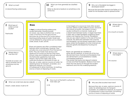
A reading comprehension that can be used to introduce information about rivers. Included is the text which is then surrounded by questions around the outside that link to the text. Answers are also included on a separate document.
Two lessons that focus on introducing or recapping some key aspects of the world including:
Continents
Oceans
Equator
Hemispheres
Tropics
The first lesson is:
A fully-resourced lesson that focuses on being able to name and locate the continents of the world and the oceans.
Included is:
A presentation that introduces the different continents and oceans, involving some discussion around these, questions and some facts around continents.
An activity that links to the presentation with questions and a map task for naming the oceans and continents. There is also a challenge question for those that finish. An answer sheet is also included for the activity.
A support sheet for the activity which is a map with the continents and oceans named.
This lesson can be used in either KS1 or 2 with a focus on teaching continents and oceans for the first time or coming back to it at the start of KS2.
The second lesson is:
An introductory lesson to the Equator, hemispheres and tropics, suitable for either Year 2 or lower KS2.
Included in the lesson is:
A presentation for the lesson that includes maps that highlight the different areas and some information for discussion, as well as a recap task from a previous lesson focusing on continents and oceans. The recap task is also included as part of the lesson pack with an answer sheet but can easily be ignored for this lesson to stand alone.
An activity that requires children to label the various aspects discussed as well as questions and a challenge question linked to the lesson. An answer sheet is also included for this.
A support sheet that provides a labelled version of the map bar hemispheres.
A lesson that focuses on being able to introduce the Americas.
Included in the lesson is:
A lesson presentation that includes maps of North America and South America to discuss as well as some introductory information to the continents. This is finished off with some true or false questions.
A recap task (this lesson is the third in a sequence having focused on continents, oceans etc.) which can be used or ignored as the lesson can stand alone or if children have been taught about continents, Equator and hemisphere then they can complete this. An answer sheet is also included for the recap task.
An independent activity that includes identifying the two continents, true or false questions and sorting countries into which continent they are part of. There is also an extension task to then research and make notes on any country from either continent. An answer sheet is also included for this alongside a support sheet with maps of North and South America.
A lesson that focuses on being able to introduce Africa.
Included in the lesson is:
A lesson presentation that includes a map of Africa to discuss as well as some information to introduce the continent with some extra detail. This is finished off with some true or false questions.
A recap task (this lesson is the fourth in a sequence having focused on continents, oceans and the Americas) which can be used or ignored as the lesson can stand alone. An answer sheet is also included for the recap task.
An independent activity that includes identifying the continent on a map, identifying different countries on the continent that start with particular letters and a true or false task. There is also a challenge question to extend understanding. An answer sheet is also included for this alongside a support sheet with a map of Africa.
A lesson that focuses on being able to introduce Asia.
Included in the lesson is:
A lesson presentation that includes a map of Asia to discuss as well as some information to introduce the continent with some extra detail. This is finished off with some true or false questions.
A recap task (this lesson is the sixth in a sequence having focused on continents, oceans, the Americas, Africa and Europe) which can be used or ignored as the lesson can stand alone. An answer sheet is also included for the recap task.
An independent activity that includes labelling Asia on a map of the world, completing true or false questions linked to the continent and identifying numbered countries on a map of Asia. There is also a challenge question to extend understanding. An answer sheet is also included for this alongside a support sheet with a map of Asia.
A lesson that focuses on being able to introduce Europe.
Included in the lesson is:
A lesson presentation that includes a map of Europe to discuss as well as some information to introduce the continent with some extra detail. This is finished off with some true or false questions.
A recap task (this lesson is the fifth in a sequence having focused on continents, oceans, the Americas and Africa) which can be used or ignored as the lesson can stand alone. An answer sheet is also included for the recap task.
An independent activity that includes answering some questions about Europe, identifying countries that begin with a particular letter and identifying numbered countries on a map of Europe. There is also a challenge question to extend understanding. An answer sheet is also included for this alongside a support sheet with a map of Europe.
A lesson that focuses on being able to introduce Antarctica and Australia/ Oceania.
Included in the lesson is:
A lesson presentation that includes a world map to discuss as well as some information to introduce the continents with some extra detail. This is finished off with some true or false questions.
A recap task (this lesson is the seventh in a sequence having focused on continents, oceans, the Americas, Africa, Asia and Europe) which can be used or ignored as the lesson can stand alone. An answer sheet is also included for the recap task.
An independent activity that includes labelling Australia, Antarctica and key oceans on a map of the world, answering questions and completing true or false statements. There is also a challenge question to extend understanding. An answer sheet is also included for this alongside a support sheet.
A fully resourced unit of work with nine lessons focusing on general world geography.
Included in the lesson sequence is:
Lesson 1 - Continents and Oceans
Lesson 2 - Hemispheres, tropics and the Equator
Lesson 3 - The Americas
Lesson 4 - Africa
Lesson 5 - Europe
Lesson 6 - Asia
Lesson 7 - Australia and Antarctica
Lesson 8 - Countries and Continents
Lesson 9 - Review Lesson
Each lesson includes a lesson presentation, including necessary maps, discussion points and questions. There is also an activity with challenge questions for every lesson with an answer sheet included for each of these. Lessons 2 through to 8 also have a recap task to support retention of prior learning with an answer sheet also included for each of these.
Support sheets are also included for each lesson where necessary whilst the final lesson provides the opportunity to review the unit.
Two fully-resourced lessons that focus on introducing or recapping the geography of the United Kingdom and Great Britain.
The first lesson focuses on looking at the difference between Great Britain and the United Kingdom as well as then being able to locate and identify the countries on a world map. This is followed up with identifying the U.K on a world map as well as identifying the countries as separate outlines. Included is a lesson presentation with modeling and discussion as well as an independent activity that includes an answer sheet.
The second lesson focuses on recapping the first lesson as well as then identifying the capital cities of the four countries and the sea and oceans surrounding the United Kingdom. Included is a lesson presentation that provides the chance to model and discuss, a recap task linked to the previous lesson to support retention of learning and independent activities linked to the learning. An answer sheet is included for both the recap task and independent activities.
Two fully-resourced lessons that focus on looking at cities in the United Kingdom and being able to use different compass points.
The first lesson focuses on looking at different types of settlement and being able to identify these by images/ by description. This then moves on to focusing on cities in the United Kingdom, identifying cities on a map as well as then being challenged to find more cities for each county of the United KIngdom. Included is a lesson presentation with modeling and discussion as well as independent activities that includes answer sheets. There is also a recap task based on previous lessons in the sequence to identify capital cities of the UK and seas and oceans.
The second lesson focuses on different compass points, recapping the four compass points and using the eight compass points. These are then used to link to the first lesson in being able to describe the position of one city to another using compass points. Included is a lesson presentation that provides the chance to model and discuss, a recap task linked to the previous lesson to support retention of learning and independent activities linked to the learning. An answer sheet is included for both the recap task and independent activities.
Pictures of settlements and compass points are courtesy of Pixabay