I'm a Geography teacher with experience educating at various levels, ranging from mainstream schools, SEN and extra-curricular tuition. I also have experience in teaching humanities, English and PSHE topics. My resources are designed primarily as schemes of works for mainly Geographical topics with all levels considered
I'm a Geography teacher with experience educating at various levels, ranging from mainstream schools, SEN and extra-curricular tuition. I also have experience in teaching humanities, English and PSHE topics. My resources are designed primarily as schemes of works for mainly Geographical topics with all levels considered
For five hundred years Petra was forgotten by the outside world, a fiercely guarded secret known only to the local tribe’s people. However a gentleman named Burckhardt, a ninetieth century adventurer tricked his way in by posing as an Indian who wanted to make a sacrifice at the tomb of a prophet.
Today Petra is renowned worldwide and protected as a World Heritage Site, yet it is under threat. Time is taking its toll as the red sandstone used to build the city is soft and crumbling and Petra is in danger of being worn away.
The Petra National Trust has called upon your students to put signs up to help tourists behave in a way to help preserve site. They need to design three signs for this project, but first need to consider the site they are meant for and how the signs should look.
Please like and follow us on Facebook @WillsonEducation or Pinterest @willsoned for more exciting resources, activities, and upcoming events to incorporate into your lessons.
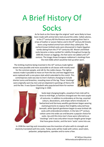
I was challenged by my sister to produce a resource about socks, challenge accepted and here it is! :-D
This booklet takes the students through how their simple socks are related to geography and the world. After a brief history of socks, they investigate where and how cotton is produced, and the production line from farmer to customer. Focusing primarily on factories in LEDCs and the working conditions, Fairtrade is examined to see how farmers are being helped with their cotton crops and how cotton works as an economic activity.
A range of individual and group activities are incorporated within this booklet, including, gathering research from print and video, drawing a story board, annotating maps, their thoughts and ideas, choropleth maps and word fills.
Please like and follow us on Facebook @WillsonEducation or Pinterest @willsoned for more exciting resources, activities, and upcoming events to incorporate into your lessons.
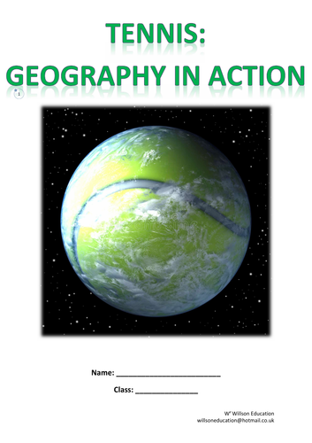
This booklet introduces students to the global links within sports, specifically tennis. Wimbledon is studied in reference to where food and drink are sourced and how its 2013 ‘Master Plan’, launched in 2013, aims to make the competition more sustainable, from reducing landfill waste, advertising recyclable bottles, serving vegan options and reducing the tennis balls air miles! How tennis balls are made, and by whom, is looked at in addition to Wimbledon working with Water Aid and tennis as an economic activity. The unit concludes with the students designing a logo and brand for their school’s tennis competition.
A range of individual and group activities are incorporated within this booklet, including, gathering research from print and video, drawing a story board, annotating maps, their thoughts, and ideas, drawing graphs and completing choropleth maps.
Please like and follow us on Facebook @WillsonEducation or Pinterest @willsoned for more exciting resources, activities, and upcoming events to incorporate into your lessons.
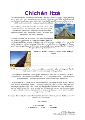
The stepped pyramids, temples, columned arcades, and other stone structures of Chichén Itzá were sacred to the Maya and a sophisticated urban centre of their empire from 750 to 1200 AD. Viewed as a whole, the incredible complex reveals much about the Maya and Toltec vision of the universe—which was intimately tied to what was visible in the night skies of the Yucatán Peninsula.
The most distinguishable structure is the Temple of Kukulkan, also known as El Castillo. This step pyramid shows the accuracy and importance of astronomy to the Maya – This influence came primarily from the Toltecs who invaded around 1000 AD and who merged their two cultural traditions.
This lesson gives your students the chance to build their own Temple Of Kukulkan and test the shadow produced to see how successful the Maya People were at producing an accurate calendar.
These worksheets help your students to learn about the history of how Machu Picchu was discovered by the Western World and how it is used today as a tourism destination. The Inca Trail is also discussed.
Please email me at willswoneducation@hotmail.co.uk for the two videos to go with this lesson
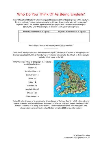
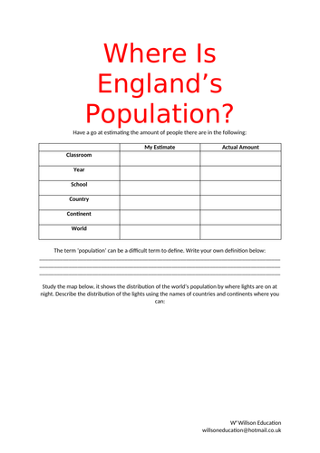
England is often thought of as a multicultural society due to the huge diversity which exists within it. London especially is incredibly diverse, with over 250 different languages spoken there every day, and so it’s referred to as being ‘super-diverse’. This diversity has evolved over many years.
These worksheets help your students to explore the make up of the English people as well as discuss why so many people move to England and the benefits and problems these people may be considered to bring with them. They are asked to express their opinion while backing these up with facts. A chance is also given to explore where their families have moved too and from.
This eight page resource helps students to understand the positioning of the population of England, how human and physical features can effect this and looks at why the south of England is growing in popularity. Activities include drawing graphs, interpreting these and cartoons, as well as wordfills and essay style questioning
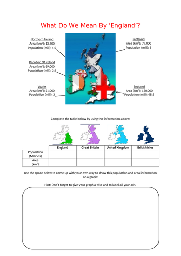
These worksheets help your students to determine between the countries which make up the United Kingdom and the British Isles through a range of activities, including graphs, wordfills, venn diagrams and maps.
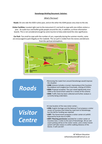
Stonehenge is a prehistoric monument located in Wiltshire, about eight miles north of Salisbury. It’s a world famous site of circular set large standing stones. It’s believed the stones were erected about 2200BC. In 1986 the site and it surrounding area were added to the UNESCO’s (United Nations Educational Scientific and Cultural Organization) list of World Heritage Sites. Stonehenge itself is owned by the State and managed by English Heritage while the surrounding area is owned by the National Trust.
These worksheets ask the students to discuss the impacts a popular tourist attraction can have on the surrounding area, they look into the different groups who would have a interest on how the problems could be managed and produce a comic strip describing the global issues surrounding Stonehenge.
Sherwood Forest is most famous for being the legendary home of Robin Hood, a heroic outlaw of English folklore. It is said he was an expert archer and swordsman, traditionally dressed in green and is often portrayed as ‘robbing from the rich and giving to the poor’ alongside his band of merry men.
Today, Sherwood Country Park is a heritage site of international importance, welcoming over 350,000 visitors a year. The Park works closely with a number of conservation and ‘green’ groups such as English Nature, the Countryside Commission and the nature Conservation Council. The groups are committed to managing the sustainable development of the forests natural resources, heritages and scientific interest, and the enjoyment and education of its visitors.
The students task is to question what insight they can gather from a photograph or image besides the obvious as well as carry out their own research of the woods to produce an in depth Trip Adviser review for others.
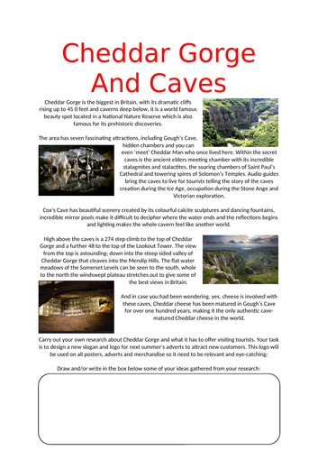
Cheddar Gorge is the biggest in Britain, with its dramatic cliffs rising up to 45 0 feet and caverns deep below, it is a world famous beauty spot located in a National Nature Reserve which is also famous for its prehistoric discoveries.
These worksheets help students to explore this beautiful area and develop a way to attract tourist to it.
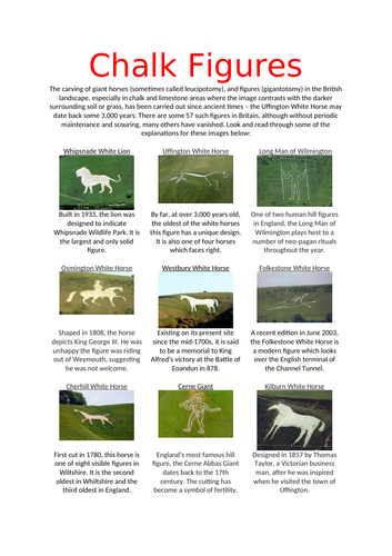
The carving of giant horses (sometimes called leucipotomy), and figures (gigantotomy) in the British landscape, especially in chalk and limestone areas where the image contrasts with the darker surrounding soil or grass, has been carried out since ancient times – the Uffington White Horse may date back some 3,000 years. There are some 57 such figures in Britain, although without periodic maintenance and scouring, many others have vanished.
These worksheets explain the purpose of some of these chalk drawings and takes the students through step-by-step on how to draw a field sketch.
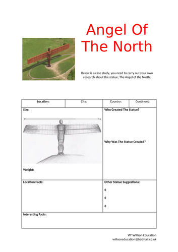
Since spreading its wings in February 1998, Antony Gormley’s Angel of the North in Gateshead has become one of the most talked about pieces of public art ever produced. This worksheet helps students to find out about the Angel and its purpose.
This PowerPoint is divided into geographical topics and emphasizes several popular films which could be used within the classroom to demonstrate physical and human features. A number of children’s films include ‘extras’ which are educational as well as entertaining.
Here you will find a list of popular films which could be used within your lessons to help understand some of your students initial ideas of various geographictopics and the ‘extras’ you may not be aware of.
Please let me know of any others you may know of to add
Please like and follow us on Facebook @WillsonEducation or Pinterest @willsoned for more exciting resources, activities, and upcoming events to incorporate into your lessons.
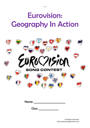
This unit of work encourages students to appreciate the links between music and Geography, through traditional music and Eurovision. Why music is popular, the many genres and when music is used is studied and investigated for its links.
Traditions from Brazil, China, England, India, and Russia are investigated for their similarities in instruments, dances, and festivals. Music as an economic activity is explored, in addition to festivals in the United Kingdom and why they maybe located where they are. Local venues to the students, both indoors and outdoors, are investigated for their suitability for hosting a music festival.
The history and who participates in Eurovision is discussed with the positive and negative impacts of having such an event hosted in their country or town. How such an event can cause community conflict through economic, social, and environmental impacts, as well as how these events could be made more sustainable are explored.
The unit concludes with the students designing a brand and logo for a sustainable music festival at their school. The final designs are then peer assessed.
A range of individual and group activities are incorporated within this booklet, including, gathering research from print, annotating maps, their thoughts, and ideas, calling on their local knowledge and effectively assessing other work.
Please like and follow us on Facebook @WillsonEducation or Pinterest @willsoned for more exciting resources, activities, and upcoming events to incorporate into your lessons.
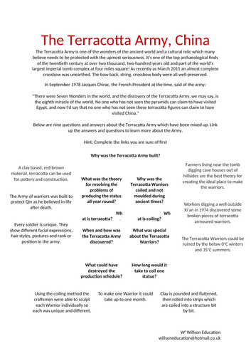
The Terracotta Army is one of the wonders of the ancient world and a cultural relic which many believe needs to be protected with the upmost seriousness. It’s one of the top archaeological finds of the twentieth century at over two thousand, two hundred years old and part of the world’s largest imperial tomb complex at four miles square! As recently as March 2015 an almost complete crossbow was unearthed. The bow back, string, crossbow body were all well-preserved.
These worksheets help your student to discover more about the Terracotta Army and who discovered them, local farmers who were digging a new well. Their task is to write a letter to their family as one of the farmers who first discovered the Warriors or a report for a magazine as one of the archaeologists who helped unearthed the other pits.
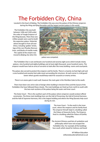
Located in the heart of Beijing, The Forbidden City was once the palace of the Chinese emperors during the Ming and Qing Dynasties and the largest ancient palace in the world.
The Forbidden City was built between 1406 and 1420 under the order of Yongle Emperor of the Ming Dynasty. More than one million people were used to build the expensive palace. Materials where brought in from all-over China, including ‘golden’ bricks, logs of the rare Phoebe Zhennan trees, and blocks of marble made. The capital of the empire was moved to Beijing city when the palace was competed.
The students task is to carry out research on the Forbidden City to discover what it has to offer and more about the city around the palace. They go on to design a slogan and logo for the ancient tourist attraction which will be used on all posters, adverts and merchandise.
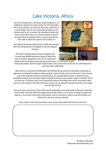
Lake Victoria is situated between Kenya, Uganda and Tanzania and 68,800 kilometres squared (about the area of Ireland). Regardless of its size it’s extremely shallow with the deepest point being only 82 meters. It’s one of the largest fresh water bodies and the largest tropical lake in the world with a shore line of 3,440 kilometres and more than 3,000 islets.
Lake Victoria is a top tourist destination with the bordering countries individually embarking on aggressive marketing strategies to attract people. Tourism to the area has increased in recent years due to the improvement of the infrastructure, for example better roads, investment in the hospitality industry such as hotels, lodges and private resorts and a greater range of activities. There are now over 170 tourist sites and a substantial amount of heritage sites which outnumber other tourist circuits thanks to the fifty world class resorts set up along the shoreline and the many island around Lake Victoria.
The students task is to carry out research on some of the tourist destinations and safari parks to discover what they have to offer and more about the region around Lake Victoria. They go on to design a slogan and logo for a new tourist safari park which will be used on all posters, adverts and merchandise.
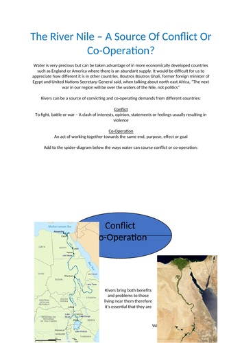
Water is very precious but can be taken advantage of in more economically developed countries such as England or America where there is an abundant supply. It would be difficult for us to appreciate how different it is in other countries. Boutros Boutros Ghali, former foreign minister of Egypt and United Nations Secretary-General said, when talking about north east Africa, “The next war in our region will be over the waters of the Nile, not politics”
Rivers can be a source of convicting and co-operating demands from different countries. These worksheets discuss the factors responsible for flooding the Nile, why the demand for water is growing in the Nile basin, the possible consequences for Egypt if water shortages arise and possible solutions.
The advantages and disadvantages of living upstream or downstream of a possible dam are discussed, as well as whether developing the land at risk of flooding should be allowed and concludes with who owns the water in the worlds major world rivers.