I'm a Geography teacher with experience educating at various levels, ranging from mainstream schools, SEN and extra-curricular tuition. I also have experience in teaching humanities, English and PSHE topics. My resources are designed primarily as schemes of works for mainly Geographical topics with all levels considered
I'm a Geography teacher with experience educating at various levels, ranging from mainstream schools, SEN and extra-curricular tuition. I also have experience in teaching humanities, English and PSHE topics. My resources are designed primarily as schemes of works for mainly Geographical topics with all levels considered
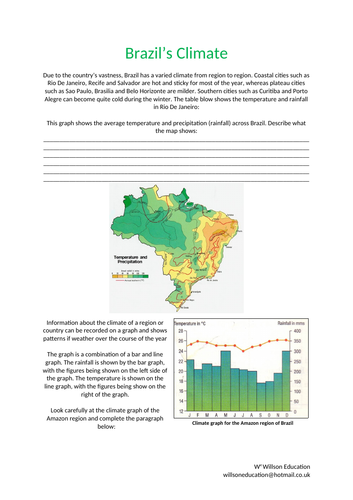
Due to the country’s vastness, Brazil has a varied climate from region to region. Coastal cities such as Rio De Janeiro, Recife and Salvador are hot and sticky for most of the year, whereas plateau cities such as Sao Paulo, Brasilia and Belo Horizonte are milder. Southern cities such as Curitiba and Porto Alegre can become quite cold during the winter.
This worksheet helps students to be able to read climate graphs as well as draw and describe them.
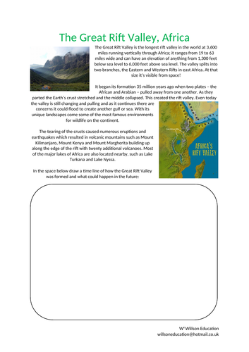
The Great Rift Valley is the longest rift valley in the world at 3,600 miles running vertically through Africa; it ranges from 19 to 63 miles wide and can have an elevation of anything from 1,300 feet below sea level to 6,000 feet above sea level. The valley splits into two branches, the Eastern and Western Rifts in east Africa. At that size it’s visible from space!
These worksheets help students to investigate the Rift Valley in Africa by exploring how it was formed and how it may change in the future. They discuss why it is considered a geographical wonder and what they think would happen to its environment should it fill with water.
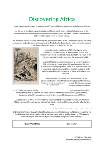
As one of the first medical missionaries to arrive in southern Africa, the first in central Africa, Dr Livingstone was frequently the first European the tribe’s people met. Their trust was won as he was a healer and medicine man and his reputation spread so far he had to restrict himself to treatment of those with only serious illnesses.
These worksheets look at Dr Livingstone travels to Africa, the students discuss what they would have packed to take with them, how they would have traveled there and the discoveries made there and how they would have helped the British Empire.
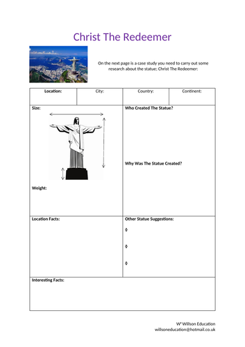
Looking over Rio De Janeiro from the 704 meter summit of Corcovado Mountain in the Tijuc Forest National Forest, the statue of Chris the Redeemer stands as a symbol of Brazilian Christianity. A Catholic priest, named Pedro Maria Boss, suggested the idea of a religious monument being built in 1850.
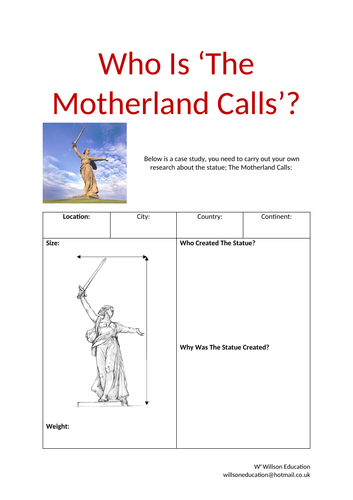
These worksheets help your students to carry out a case study of the statue, giving you the opportunity of giving them the additional sheet of information or allowing them to carry out their own research.
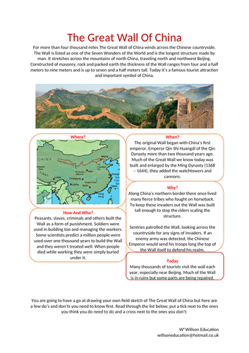
For more than four thousand miles The Great Wall of China winds across the Chinese countryside. The Wall is listed as one of the Seven Wonders of the World and is the longest structure made by man. It stretches across the mountains of north China, traveling north and northwest Beijing. Constructed of masonry, rock and packed earth the thickness of the Wall ranges from four and a half meters to nine meters and is up to seven and a half meters tall. Today it’s a famous tourist attraction and important symbol of China.
These worksheets help your students develop their field sketching skills by explaining the dos and don’ts and using the Great Wall of China as an example
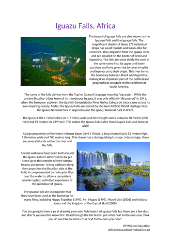
The beautiful Iguazu Falls are also known as the Iguassu Falls and the Iguaçu Falls. The magnificent display of these 275 individual drops has awed tourists and locals alike for centuries. They originate from the Iguazu River and are situated on the border of Brazil and Argentina. The falls are what divide the river of the same name into its upper and lower portions and have given rise to several myths and legends as to their origin. This river forms the boundary between Brazil and Argentina, making it an important part of the political and geographical structure of the continent of South America.
This worksheets helps your students to develop their field sketching skills by going through the important dos and don’ts and using the Iguazu Falls as an example
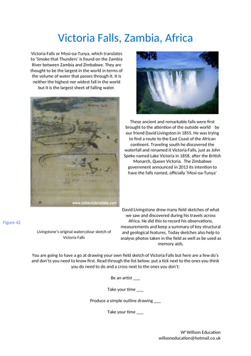
Victoria Falls or Mosi-oa-Tunya, which translates to ‘Smoke that Thunders’ is found on the Zambia River between Zambia and Zimbabwe. They are thought to be the largest in the world in terms of the volume of water that passes through it. It is neither the highest nor widest fall in the world but it is the largest sheet of falling water.
This worksheet helps your students to understand the dos and don’ts of field sketching. Victoria Falls is used as an example to help practice this important skill
This unit of work encourages students to appreciate the links between music and Geography, why it is popular, the many genres it entails and how it is used around the world.
Traditions from Brazil, China, England, India, and Russia are investigated for their similarities in instruments, dances, and festivals. Music as an economic activity is explored, in addition to festivals in the United Kingdom and why they may be located where they are. Local venues to the students, both indoors and outdoors, are investigated for their sustainability for hosting a music festival.
The unit concludes with the students designing a brand and logo for a sustainable music festival at their school. The final designs are then peer assessed.
A range of individual and group activities are incorporated within this booklet, including, gathering research from print, annotating maps, students own thoughts and ideas, calling on their local knowledge and effectively assessing other work.
Please like and follow us on Facebook @WillsonEducation or Pinterest @willsoned for more exciting resources, activities, and upcoming events to incorporate into your lessons.
This 32 page booklet gives students the opportunity to explore the FIFA World Cup, Russia and their connections to geography using different Geographical themes and skills. Chapters include:
Why Is Football So Popular?
How Is Football Linked To Geography?
Who Are FIFA?
Who’s Taking Part In 2018?
Friendly Rivals
We Are Number One!
Football As An Economic Activity
Flag Crossword
Getting The Vote
What Do You Know About Russia?
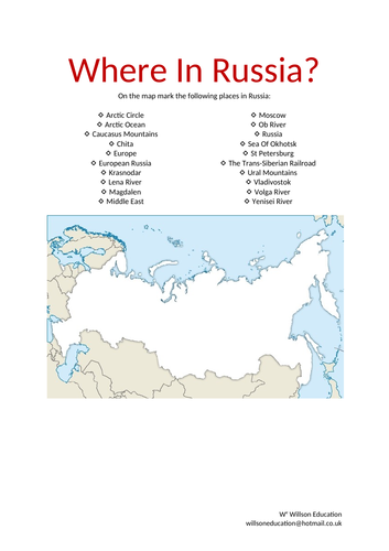
Where In Russia?
Population And Nationality
Country Climate
Seeing The Sites
What Have We Borrowed?
Build A Brand
Knowing The Neighbours
Football Acrostic
How Is This Omar Linked To Football?
These worksheets help students learn about the history of the Winter Palace in Russia through a wordfill exercise and develop the skill of field sketching
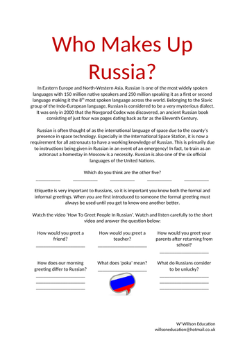
These worksheets look at the Russian language and the others which are spoken within the country as well as the religions and ethnic groups which make up the people
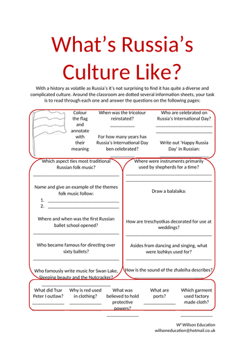
The culture of a group of people is their way of life. It includes their customs, hobbies, foods, fashions, beliefs and traditions; these are dependent of the country they live in, family background, sex and age. Many parts of the world are multicultural which means many different groups of people live alongside one another as a result of moving to new areas to live ad bringing their cultures with them.
This is a chance for your students to get out of your seats and, sensibly, move around the classroom gathering evidence with their classmates to learn about Russia’s culture
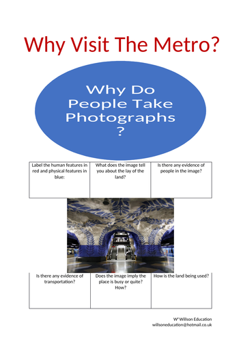
Moscow’s metro opened in 1935 with just eleven stations and attracted 285,000 inquisitive riders on its first day. Today it has expanded to include 206 stations and carries up to nine million passengers a day.
These worksheets help the students to question photographs and research the Moscow Metro through producing a Trip Advisor style review
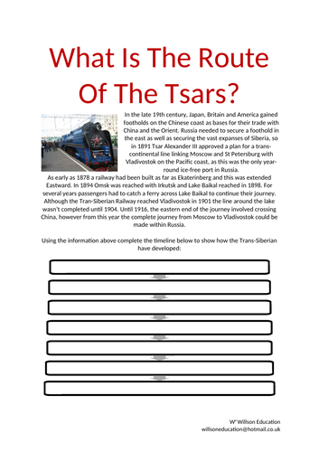
In the late 19th century, Japan, Britain and America gained footholds on the Chinese coast as bases for their trade with China and the Orient. Russia needed to secure a foothold in the east as well as securing the vast expanses of Siberia, so in 1891 Tsar Alexander III approved a plan for a trans-continental line linking Moscow and St Petersburg with Vladivostok on the Pacific coast, as this was the only year-round ice-free port in Russia.
These worksheets allow the students to study the Trans-Siberian railway, study its timeline and produce a suitable logo an slogan which could be used to advertise the journey.
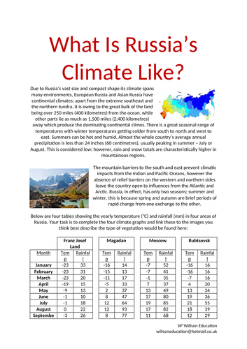
Due to Russia’s vast size and compact shape its climate spans many environments, European Russia and Asian Russia have continental climates; apart from the extreme southeast and the northern tundra.
These worksheets look at four locations within Russia and learn how to draw climate graphs and how to read them
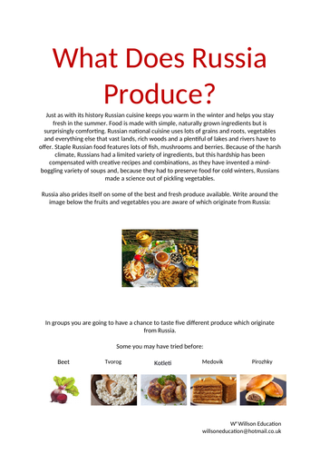
Just as with its history Russian cuisine keeps you warm in the winter and helps you stay fresh in the summer. Food is made with simple, naturally grown ingredients but is surprisingly comforting.
These worksheets give students the opportunity to try five different foods from Russia and to use their sences to describe them
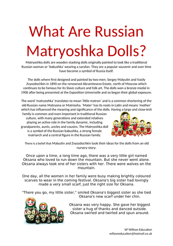
Matryoshka dolls are wooden stacking dolls originally painted to look like a traditional Russian woman or ‘babushka’ wearing a sarafan. They are a popular souvenir and over time have become a symbol of Russia itself.
These worksheets discuss the history of the dolls and the story believed to be behind it which the students up date to a modern day and design their own dolls
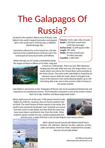
Located in the southern Siberia area of Russia, Lake Baikal is the world’s largest freshwater and deepest lake in the world and in 1996 became a UNESCO World Heritage Site.
Sometimes referred to as the Sacred Sea, the lake represents the unspoilt beauty of Russia and is the central part of many local myths and folklore. Lake Baikal is also known as the ‘Galapagos Of Russia’ due to its exceptional biodiversity and importance to evolutionary science. The freshwater ecosystem is one of the world’s richest dues to its age, isolation and deep oxygenated water.
These worksheets have the students research some of the unique flora and fauna which is found Lake Baikal and discusses the best stratagies to help protect these from the increasing number of visitors to the area.