Thank you for visiting! Here you will find a selection of printable, interactive worksheets for your classroom: Basic Geography worksheets with simple maps, ESL, Spanish, Bible, Reading Comprehension and more. I hope you find the resources useful! Reviews are welcome and very much appreciated. Thank you so much.
Thank you for visiting! Here you will find a selection of printable, interactive worksheets for your classroom: Basic Geography worksheets with simple maps, ESL, Spanish, Bible, Reading Comprehension and more. I hope you find the resources useful! Reviews are welcome and very much appreciated. Thank you so much.
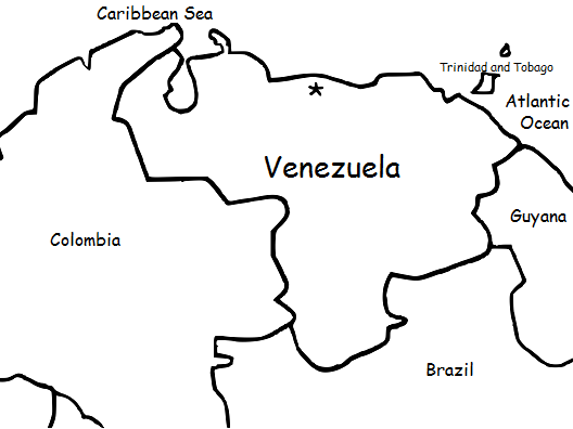
Introduce your students to Venezuela with this printable handout of two worksheets (plus answer key). Your students will read a brief overview of Venezuela (location, capital, language, flag), write 'Caracas' next to the star on the map to show the capital, color the small map of Venezuela and surrounding countries, and use the map and compass to answer (6) questions. Basic Geography worksheet with a simple map to introduce the country of Venezuela and practice cardinal and ordinal directions.
For use with Interactive Notebooks: After the handout is completed, students can cut out the map and flag of Venezuela and paste into the notebook under the topic of South America/Sub-Topic: Venezuela. Under the map, students can write a summary in their own words of what they now know about this country. Collect handouts for other countries of South America (or Spanish-speaking countries) to add to the notebook. Please browse this store for a selection of printable handouts for other countries of South America (and beyond!).
Thank you so much for using my Geography worksheets in your classroom! I hope you find them useful. Reviews are welcome and very much appreciated.
Thank you again!
Key Words: coloring page, color, cardinal, ordinal, Trinidad and Tobago, Spanish, Caribbean Sea, Atlantic Ocean
Introduce your students to Czech Republic with this printable handout of two worksheets (plus answer key). Your students will read a brief overview of Czech Republic (location, capital, flag, language), write 'Prague' next to the star on the map to show the capital, color the small flag and map, and use the map and compass to answer 7 questions. Colored pencils and a pen or pencil are needed for this activity. No other prep needed.
For use with Interactive Notebooks: After completing the handout, students can cut out the map and flag and paste it into the notebook under the topic of Europe / Sub-Topic: Czech Republic. Under the map and flag, students can write a summary in their own words of what they now know about Czech Republic. Collect handouts for all countries of Europe to add to notebook.
Thank you so much for using my Geography worksheets in your classroom! Reviews are welcome and very much appreciated. Please follow my store for more Geography worksheets.
Thank you again!
cardinal, ordinal, directions, Czechoslovakia, north, south, east, west.
Introduce your learners to Suriname with this printable handout of two worksheets (plus answer key). Your students will read a brief introduction to Suriname (location, capital, flag, language), write 'Paramaribo' next to the star on the map to show the location of the capital, trace the Suriname River and color the map, and use the map and compass to answer 6 questions on page 2. Colored pencils and a pen or pencil are needed for this activity. No other prep needed. Basic Geography worksheet with a simple map to introduce Suriname and practice cardinal and ordinal directions.
For use with Interactive Notebooks: After the worksheets are completed, students can cut out the map and flag and paste into the notebook under the topic of South America/Sub-Topic: Suriname. Under the map, your students can write a summary in their own words of what they now know about this country. Collect worksheets for other countries of South America to add to the notebook! Please browse this store for a selection of worksheets for other countries of South America (and beyond!).
Thank you so much for using my Geography worksheets in your classroom! Reviews are welcome and very much appreciated.
Introduce your students to Kaliningrad Oblast with this printable handout of two worksheets (plus answer key). Your students will read a brief introduction to Kaliningrad Oblast, draw a line from Kaliningrad Oblast to Russia to show that it is a territory of Russia, color the small map, and use the map and compass to answer 6 questions on page 2. Colored pencils and a pen or pencil are needed for this activity. No other prep needed. Basic Geography worksheet with a simple map to introduce Kaliningrad Oblast and practice cardinal and ordinal directions.
For use with Interactive Notebooks: After the worksheets are completed, students can cut out the map and paste into the notebook under the topic of Europe or Russia / Sub-Topic: Kaliningrad Oblast. Under the map, students can write a summary in their own words of what they now know about Kaliningrad Oblast. Collect worksheets for Russia and other countries of Europe to add to notebook! Please browse this store for worksheets for all countries of Europe (and beyond!).
Thank you so much for using my Geography worksheets in your classroom! Reviews are welcome and very much appreciated.
Introduce your students to the country of ECUADOR in South America with this printable handout of two worksheets (plus answer key). Your students will read a brief introduction to Ecuador (location, capital, flag, language), write 'Quito' next to the star on the map to show the capital, trace the line of the equator, color the small map, and then use the map and compass to answer 7 questions on page 2. Colored pencils and a pen or pencil are needed for this activity. No other prep needed. Basic Geography worksheet with a simple map to introduce Ecuador and practice cardinal and ordinal directions.
For use with Interactive Notebooks: After the worksheets are completed, students can cut out the map and flag and paste into the notebook under the topic of South America/Sub-topic: Ecuador. Under the map and flag, your students can write a summary in their own words of what they now know about this country. Collect worksheets for all countries of South America to add to the notebook! Please browse this store for a selection of worksheets for other countries of South America (and beyond!).
Thank you so much for using my Geography worksheets in your classroom! Reviews are welcome and very appreciated. :)
Introduce your students to Poland with this printable handout of 2 worksheets (plus answer key). Your students will read a brief introduction to Poland (location, capital, flag, language), write 'Warsaw' next to the star on the map to show the location of the capital, color the small map and flag, and use the map and compass to answer 7 questions on page 2. Colored pencils and a pen or pencil are needed for this activity. No other prep needed. Basic Geography worksheet with a simple map to introduce Poland and practice cardinal and ordinal directions.
For use with Interactive Notebooks: After the worksheets for Poland are completed, students can cut out the map and flag and paste into the notebook under the topic of Europe/Sub-Topic: Poland. Under the map, your students can write a summary in their own words of what they now know about Poland. Collect worksheets for other countries of Europe to add to the notebook! Please browse this store for worksheets for other countries of Europe - and beyond!
Thank you so much for using my Geography worksheets in your classroom! I hope you find them useful and fun. Reviews are welcome and very much appreciated!
Introduce your students to Peru with this printable handout of two worksheets (plus answer key). Your students will read a brief overview of Peru (location, capital, flag, language), write 'Lima' next to the star on the map to show the capital, color a small map and flag, and use the map and compass to answer 7 questions. Basic Geography worksheet with a simple map to introduce Peru and practice cardinal and ordinal directions.
For use with Interactive Notebooks: After the handouts are completed, students can cut out the map and flag of Peru and paste into the notebook under the topic of South America/Sub-Topic: Peru. Under the map, your students will write a summary in their own words of what they now know about this country.
Collect handouts for other countries of South America to add to the notebook. Please browse this store for a selection of printable handouts for other countries of South America (and beyond!).
Thank you so much for using my Geography worksheets in your classroom!
ntroduce your students to Brazil with this printable handout of two worksheets (plus answer key). Your students will read a brief overview of Brazil (location, capital, flag, language), write 'Brasília' next to the star on the map to show the capital, write the national motto of Brazil 'ERDEM E PROGRESSO' on the band of the flag, color the flag and map, and use the map and compass to answer 9 questions on page 2. Basic Geography worksheet with a simple map to introduce Brazil and practice cardinal and ordinal directions.
For use with Interactive Notebooks: After the handout is completed, cut out the map and flag and paste into the notebook under the topic of South America/Sub-Topic Brazil. Under the map and flag, your students will write a summary in their own words of what they now know about Brazil. Collect handouts for other countries of South America to add to the notebook! Please browse this store for a selection of printable handouts for other countries of South America (and beyond!).
Thank you so much for using my Geography worksheets in your classroom!
coloring page, cardinal, ordinal, Portuguese