

Full resource for a Maths Lesson on the mathematics behind predicting the path of, and area of destruction of a tornado. (Used with Year 10 middle/top sets)
Could also be used as a Geography lesson with a heavy emphasis on Numeracy.
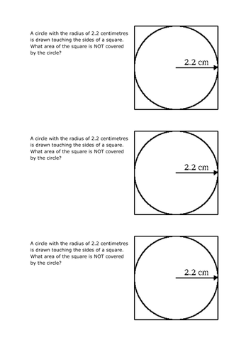
Starter gets students thinking about how to calculate the area of a circle.
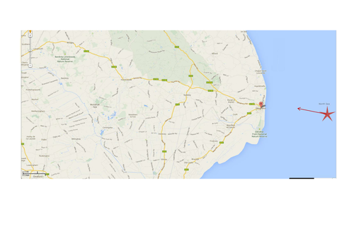
The scenario is fictitious and considers a tornado off the coast of Lincolnshire. Map provided, with scale correct if printed out on A4 paper.
Calculations take a lesson, then students could be asked to produce a poster of their findings/calculations.
Maths skills used: Area of a Circle, Scale Drawing, Ratios, Speed/Distance/Time calculations, Loci.
SMSC/Cross-curricular links: Tornadoes, Map reading, Using a scale drawing, research as an extension.
Could also be used as a Geography lesson with a heavy emphasis on Numeracy.
Starter gets students thinking about how to calculate the area of a circle.
The scenario is fictitious and considers a tornado off the coast of Lincolnshire. Map provided, with scale correct if printed out on A4 paper.
Calculations take a lesson, then students could be asked to produce a poster of their findings/calculations.
Maths skills used: Area of a Circle, Scale Drawing, Ratios, Speed/Distance/Time calculations, Loci.
SMSC/Cross-curricular links: Tornadoes, Map reading, Using a scale drawing, research as an extension.
Something went wrong, please try again later.
This resource hasn't been reviewed yet
To ensure quality for our reviews, only customers who have purchased this resource can review it
Report this resourceto let us know if it violates our terms and conditions.
Our customer service team will review your report and will be in touch.
£2.00