My shop is a non profit making concern & it supports homeless charities (Crisis, The Salvation Army & The Berwick Youth Project). Teaching has been my life & I continue to support learning around the World. My subjects were: History, Geography and Physical Education. I have competed in a wide variety of sports inc.: Gymnastics, Badminton, Rugby, Football, Athletics & many others. Check out my recent bundle with 11 of my best publications. A vast amount of support material on offer.
My shop is a non profit making concern & it supports homeless charities (Crisis, The Salvation Army & The Berwick Youth Project). Teaching has been my life & I continue to support learning around the World. My subjects were: History, Geography and Physical Education. I have competed in a wide variety of sports inc.: Gymnastics, Badminton, Rugby, Football, Athletics & many others. Check out my recent bundle with 11 of my best publications. A vast amount of support material on offer.
This resource is a Tudor timeline covering the main people and events that took place between 1485 and 1603. It is ideal for teachers delivering information about the reign of the Tudors. The resource covers a little more than 118 years of History and would be an ideal support for teachers of History in both the Primary and Secondary sectors. Included are 90 images of people, documents, castles, maps, battles and many other connected visual aids that can support the delivery of History lessons. Throughout this year (2020 - 2021) all of my resources support homeless charities and I hope that with your help we can give a few people on the streets much needed support in getting their lives back on track. Good luck in your Schools and Colleges this coming year 2020 - 2021.
Ian Patterson (IanPCostaDelSol).
All income on this resource will go to Homeless Charities in 2020. Perfect for students who are studying WWI, Adolf Hitler and political struggles in Germany. Massive price reduction!!
This bundle is aimed at combining a wealth of information about both the Weimar Republic and the part played by Adolf Hitler in its downfall. The following resources have been combined:
Free Resource - Development of a Dictatorship 1918 to 45 (A comprehensive timeline tracking the highs and lows of Germany from the end of WW1 to the end of WW2)
1 - The Rise and Fall of the Weimar Republic (A Presentation)
2 - The Rise and Fall of the Weimar Republic (Timeline, Revision Cards, Game and Wall Display)
3 - Adolf Hitler 1889 to 1918 (Factfile & Tasks)
4 - Adolf Hitler 1889 to 1918 (A Presentation)
Resource 3 & 4 highlight Hitler’s background and looks into the reasons why he followed a path to disaster. These resources are targeted at Years 9 through to Year 11.
Any income from this resource will go to Homeless Charities in the UK
A selection of basic skills for learning about maps. Topics covered include: Use of symbols, Directions and Bearings, Grid References, Contours, Scales and Distances on maps.
This resource offers introduction to map skills and gives the opportunity for students to complete work challenges. This resource unit is best suited to students from 10 years through to 16 years of age.*
A 268 page document with over 50 outline maps from around the World. This resource book is to be used in conjunction with a school atlas. There are a multitude of exercises and challenges for students to use as homework or in the classroom with or without guidance from the teacher. Also included, there are over 180 photographs from the UK and around the World that can be used individually for lesson starters or as topic slide shows.This resource work book can be used with a wide range of age groups. The outline maps and questions are suitable for children between the age of 9 to 16 years. The content has a wide degree of differentiation for more and less able children. The many pictures included in this document are ideal as introductions to new topics. Although the main focus of this resource is on Geography, much of the content can be linked to, Travel and Tourism, History, English and Social Studies. Special featured sections: China, London, Spain, Bristol and WW1 Flanders. All income from this resource will be donated to 3 Homeless Charities in 2021 . The Salvation Army, Crisis and The Berwick Project.
A Taste of Orienteering - Getting Ready for Your First Event. This chapter aims to help the beginner to become familiar with the many experiences and challenges facing the newcomer to this exciting outdoor sport.
This Power Point Presentation is the second in a series of coaching notes for this amazing sport of Orienteering. It is dedicated to our departed friend, James Ross who was an established and successful Orienteer. He was a member of the well-established Malaga Orienteering Club. All commission gained from this resource will be donated to selected Cancer organisations.
So where do we start? Here is a list of the topics covered in this presentation:
Checking out your local Club and what is on offer. 2. Make contact and find out the many activities and experiences available. 3. Events can be either “Town and Country” (Urban or Rural), a huge contrast. 4. Become familiar with the Club websites. 5. What might we expect to find at the start line? 6. The first few seconds of any test or race are vitally important especially for novices! 7. As we progress, we will become familiar with both the map and the compass. 8. Gradually we will gain confidence and become familiar with directions, distances and many contrasting landscapes. 9. A clever thumb will improve our navigational skills!? 10. At the end of each event we will become familiar with the finish line and checking in at the download station. 11. Finally we should show gratitude to the planners and organisers who give of their time freely for the benefit of others and this incredible outdoor sport.
Orienteering is very much a family sport, and it offers huge benefits to young and old alike. Check out this presentation and become involved in something very special.
The sport of Orienteering needs to be broken down into bite-size skills so that the beginner can establish the most important principles of this incredible activity. In this presentation I have selected ten elements that I believe to be essential learning steps for the novice orienteer. I have included the following topics in order to lay the foundations for success in this activity:
Knowing your north from your south! 2. Translating the symbols into an accurate mental image of the land features. 3. Making the most of the map key. 4. Getting to grips with scale and distances. 5. Understanding contours and being able to convert the patterns into mental pictures. 6. Keeping in touch with your exact location by using your thumb! 7. A personal understanding of your stride distancing. 8. Making use of rough bearings. 9. Knowing how to use map handrails. 10. On a navigation leg, make the most of the collecting or gathering features between control points.
These key principles of navigation and map reading skills will serve you well in this incredible sport. As with all my resources, I offer this resource at minimum cost in order to support my three chosen homeless charities. I am grateful to the Malaga Orienteering Club for permission to use many of the images and videos on offer in this presentation.
This resource is offered as an introduction to how maps evolved and the subsequent development of Orienteering as a sport. It is offered as a Power Point Presentation and it lays the foundation for a programme of 9 more presentations that highlight the many skills and coaching topics to be experienced in this amazing sport (Orienteering). The ten presentations have been written in both English and Spanish. Many of the slides show the diversity of the Spanish landscape as captured by the many members of “The Malaga Orienteering Club in Spain.” The presentations can be adapted for viewing by Upper junior students (9 - 10 yrs.) through to adult age groups. This presentation includes topics such as: Comparisson of ancient maps through to modern day orienteering maps; Early maps and cartography; The compass rose; The Earth’s magnetic field, The magnetic compass and how it can be used with the Orienteering map. The presentation sets the foundation for many more coaching aspects covered in the follow up programme of wide ranging topics. These resources are a non profit making venture and any income will be forwarded to three selected homeless charities (Crisis, The Berwick Project and the Salvation Army). As an extension to the use of this resource, teachers may wish to use the text, images and possible video links to other topics such as: Geographical landscapes, The Spanish language, The History of Maps and as an introduction to the sport of Orienteering. The introductory videos (one of two in the presentation), gives a true taste of this amazing outdoor sport. Permission to show the videos in this and all ten presentations has been granted by Malaga Orienteering Club with the gratitude of (Ian Patterson) the author of this presentation.
This Powerpoint Presentation is specifically targeting 13 to 16 year old students of History. There are 22 slides with a selection of appropriate pictures, fact files and maps included. It is an introductory part of a wider document about “The Development of a Dictatorship – Adolf Hitler”. The resource documents the early years of Hitler up to the end of World War One and it looks more closely at the experiences that shaped his life. Who and what influenced him as he was growing up in Austria and how did being part of an Infantry Regiment in WW1 mould his character. The critical question is asked, how and why did Hitler take his chosen path to infamy?
In terms of historical understanding, many National Curriculum prerequisites have been covered and include evidence, continuity, change, cause and effect, perspectives, empathy, significance and contestability. However in short, the most important content is evidence of how and why Adolf Hitler turned into a cruel demagogue. A key element in the presentation is the chronological nature of the study. The World War 1 years also offer an ideal opportunity to learn more about the advances in technology.
There are 22 slides with images that are followed by suggested challenges for students to complete. The slides containing maps are available for printing and use in lessons.
Slide 25 offers suggested ways in which the presentation can be managed in the classroom.
Slide 26 to 38 contains sets of quiz questions that are differentiated for a wide range of abilities.
Slide 39 offers writing challenges that are aimed at helping 13 year old students to extend their writing skills from a basic level to advanced levels in preparation for higher examination targets in the future.
Slides 40 to 45 are script notes for use by students who can take part in the presentation if directed by the teacher. This unit of work is ideal for between 3 and 6 hours of commitment in the classroom and possibly for use as a homework challenge.
Adolf Hitler 1889 to 1918 – His Early Years and WW1 - This resource comes in the form of a fact file and a selection of classroom exercises that are aimed at 13 to 16 year old students of 20th Century History. In addition to this there is a small section (images) that would be suitable for the PSHE programme especially in the month of November. The material in this 21 page resource documents the birth of Adolf Hitler through to the conclusion of WW1. It contains written information, pictures, maps, quiz questions and research challenges. The research challenges are ideal for perhaps two internet sessions where students need to search for extra information. The contents are best suited for Key Stage 3 and students in Key Stage 4 preparing for History examinations, particularly the topics “The Rise of Adolf Hitler”, “Development of a Dictatorship” and “The Events of WW1”. The resource materials offered should satisfy between 4 and 8 hours of work in the classroom. As an alternative it may also be offered as a home research project in preparation for GCSE examinations.
This resource can be linked and used alongside - Adolf Hitler - Early Years (Powerpoint Presentation created by this same author).
Income for this resource will go to homeless charities. The work serves to satisfy the type of work associated with field studies and research. The content targets Geography, Travel and Tourism and Business Studies students from 14 to 16 years of age. They will gain experience in handling data related to service industries. The work serves to satisfy the type of work associated with field studies and research. The data is presented on a spreadsheet that highlights the Service Industry of Poole in Dorset. Using the information, students will be able to propose a hypothesis and then attempt to prove or refute the chosen statement.
Within the folder there is a power point presentation that can be used independently as a collection of Geography topics about the English County of Dorset. Specifically it addresses the concepts of Site, Situation and Function of a settlement. The power point presentation alone can be used to support up to 10 contrasting lessons. The photographs can be used for introductions to a number of Human and Physical Geography topics including the following specifics and links:
Poole Port, Service Industry, Tourism, Shopping Streets, Spreadsheet statistics, Bays and Headlands, Lulworth Cove, Lulworth Village, Swanage Bay, Groynes, Stair Hole, Durdle Door, Corfe Castle, Dorset Geology, Settlements, Site, Situation, Function and finally a number of excellent photographs that can be converted to field sketch diagrams.
Orienteering - PPP7
Symbols - Quiz One
In order to navigate an Orienteering map, it is essential to have a fair grasp of the map symbols. Presentation 7 is offered in the form of a Quiz. Included are 25 contrasting examples.
Included are: Vegetation types, man-made structures, water features, natural formations and a variety of other common inclusions that can be found on Orienteering maps.
Orienteering - PPP8
Symbols - Quiz Two
As with Presentation 7 this is the second of two presentations that will help the Orienteer to become familiar with the map symbols. Presentation 8 again offers a selection of 25 map symbols. They are presented as a quiz challenge that can be repeated several times. This will help individual orienteers to become familiar with the many symbols included on Orienteering maps. A mixture of all symbol types has been included.
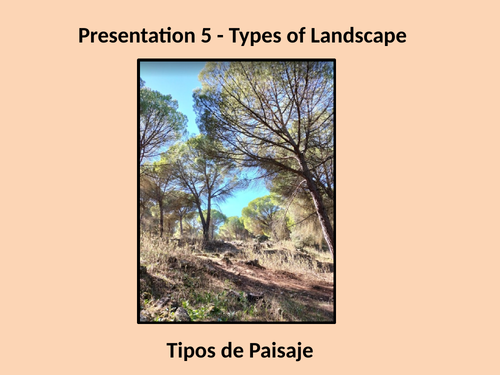
Orienteering P5 & 6 - Types of Landscape & Control Descriptions.
PPP5 - The outdoor adventure sport of Orienteering makes the most of all types of landscape. This presentation explores the many types of geographical environments that have been captured on orienteering maps. The competitor in Orienteering has the opportunity to experience the following and many other varieties of landscapes: 1. Forests with many different trees. 2. Runnable woodland. 3. Thick vegetation with slow progress. 4. Farmland meadows and orchards. 5. Open parkland and scrubland. 6. Moors and land with rocky outcrops. 7. Urban landscapes with alleys, back lanes and many stairways. These can make navigation very challenging with the many twists and turns! This presentation gives you a taste of how diverse the scenery in this amazing sport can be.
PPP6 -
This presentation entitled “Making the most of Control Descriptions” explores the connection between the shape of the landscape and the symbolic representation of the physical features with how they appear on the map. The sport of orienteering involves visiting a number of actual locations pin-pointed on the orienteering map being used. The event organisers must prepare races for each different age group. Each set of control descriptions are set out in numerical order. The presentation starts with an experienced orienteer who explains the basics to any beginners so that they know what to expect. It also highlights how control descriptions help all orienteers to become successful. The following aspects are covered: 1. Early guidance on what to expect at your first event. 2. There are at least 8 different types of control descriptions on the guidance sheet. 3. Images and symbols are used to give a visual picture linking the landscape with the map symbols. 4. A few examples of control descriptions and map types are included. 5. The examples can be used to challenge and test the group or individual.
These two presentations will help both the beginner and the intermediate to make good progress. They will soon progress to advanced levels in this incredible sport.
Any income made from these two power point presentations will be donated to three different homeless charities (Crisis, Salvation Army and The Berwick Project).
This resource is a two lesson powerpoint presentation that tracks the developments of the Weimar Republic from its conception (1918) to its final demise (1933). In particular it features the political rise of Adolf Hitler from Lance Corporal to Fuhrer. It takes the form of a timeline of events and the frames can be reduced to create a pack of 48 revision cards. This presentation is ideal for students of History between the ages of 14 and 16. Frames 52 and 53 can be printed for students to compile brief notes on the two presentations. This is a quick fix exercise to help students to put the key events of the Weimar Republic into chronological order. All abilities can learn from the images and discussions inspired by this resource.
Geography Bundle - Price Reduction - Amazing value for money!
All income in 2021 will go to Homeless Charities.
This Geography resource is ideal for home learning.
It is everything I needed when I first started teaching Geography. It targets children from the age of 8 through to 16 and it includes: 1) World Mapwork Skills & literacy. Every possible outline map for Britain, Europe and the rest of the World is included. 2) Basic Skills for teaching OS - mapwork.
3) How to interpret pictures and then convert them into field sketch images.
There are also many challenges offered for writing sentences and passages using geographical terminology and vocabulary. This bundle is a special offer to young teachers of Geography in the Secondary sector. It also targets (KS3 and KS4) . Junior School Teachers responsible for delivering Humanities at Key Stage 2 Level will also find this resource invaluable. The whole package makes up 100’s of lessons.
This resource is aimed at giving Geography, Travel and Tourism and Business Studies students from Years 9 through to 11 the experience of handling data related to service industries. The work serves to satisfy the type of work associated with field studies and research. The data is presented on a spreadsheet that highlights the Service Industry of Poole in Dorset. Using the information, students will be able to propose a hypothesis and then attempt to prove or refute the chosen statement.
Within the folder there is a powerpoint presentation that can be used independently as a collection of Geography topics about the English County of Dorset. Specifically it addresses the concepts of Site, Situation and Function of a settlement. The powerpoint presentation alone can be used to support up to 10 contrasting lessons. The photographs can be used for introductions to a number of Human and Physical Geography topics including the following specifics and links:
Poole Port, Service Industry, Tourism, Shopping Streets, Spreadsheet statistics, Bays and Headlands, Lulworth Cove, Lulworth Village, Swanage Bay, Groynes, Stair Hole, Durdle Door, Corfe Castle, Dorset Geology, Settlements, Site, Situation, Function and finally a number of excellent photographs that can be converted to field sketch diagrams.
The Tudors - From Start to Finish. This resource has been compiled as a time line of events and can be used as an independent home study or Zoom project. This Story about the Tudors is a comprehensive document in the form of a Power Point Presentation. There are over 100 images that give a taste of all that happened during this period of History. The study looks at the highs and lows of the main characters that lived and died during the reign of the Tudors. The whole package takes the form of 15 power point lessons that covers almost every possible topic that can be included within the Tudor Period. Topic examples include: Religion, Rebellion, War, Family, Execution, Affairs at home, Affairs abroad and Slavery to name but a few. Each lesson is concluded with a revision quiz that gives the children the opportunity to develop their writing skills. As all teachers know, History and use of the English language go hand in hand. This resource offers children from the age of 9 through to 16, a colourful opportunity to fully understand what happened during the reign of the Tudors as well as offering an extended project that develops individual literacy skills. The study can be delivered on three levels giving teachers the opportunity to use this resource with different age groups and ability levels.
KS2 topics covered: Teaching Chronology, Black People / Slavery, Spanish Empire, Literacy and History.
KS3 topics covered: Early Modern (16th & 17th Century), The Reformation, Henry VIII + Elizabeth I.
All commission income this year (2022) will go to three different homeless charities. They are: Crisis, Salvation Army and The Berwick Project (Keeping young people off the streets).
This resource targets students studying the Weimar Republic during the period 1918 to 1933. They are most likely to be involved in learning about History in Germany for GCSE examinations in the time period between the two World Wars. Specifically it is aimed at learning time order in this complicated and rapidly changing period of History. There are two main elements to this resource. It starts with a timeline presentation that can be taught as two introductory lessons. After this initial introduction the 48 revision cards can be used to create a wall display and then followed up with a series of revision games that help students to learn the correct order of events during the Weimar years in Germany. As the end of Key Stage 4 examinations get closer the revision cards will be very useful for individual, partner and group revision sessions.
This Project offers an insight into the characteristics of the Yorkshire Dales National Park and it encompasses a taste of the History and the Geography of this diverse area of Northern England. Throughout this resource there is an offering of challenges and tasks for students to attempt. Sub topics include: Glaciation, Geology, Industrial Roots, Roads and Railways, Town and Countryside, Limestone Scenery, Farming, Mapwork Skills and a few others. In total there is enough work for at least 10 lessons that will encompass a wide range of geographical skills within the one project. It is suitable for students with a wide range of abilities from the age of 10 to 16 years. I would introduce this project by looking back at the history of the National Parks. My second focus would be the wider pattern of parks within the USA and then lead into the project which is based specifically on The North Yorkshire National Park in the United Kingdom.
Ten Orienteering power point presentations, highlighting the many different skills involved in this incredible individual, family and team sport. There are many maps, images and videos included, that help the individual competitor to develop their knowledge and become familiar with the multitude of skills and experiences on offer in Orienteering. Topics included are: Landscapes, Historical connections, Navigation, Mapwork skills, Beginners advice, What to expect at your first event and many more coaching elements.
This resource can be used in Spain and the UK as the slides and commentary are written in both English and Spanish.
The presentations would be ideal to use as an introduction for examination candidates who have chosen the Outdoor Adventurous Sport of Orienteering as one of their physical activities. The whole resource would serve as an ideal introduction and learning experience for both individual candidates and families who become involved in this sport.
This resource is on offer for a limited period (extended from 3 to 12 months) at half price.
Any income from this resource will be sent to the following three homeless charities (The Berwick Project, The Salvation Army and Crisis).
Thank you … Ian Patterson.
A vast collection of teaching materials from a lifetime of experience. 60% saving. This large bundle will serve a large number of young and experienced teachers alike. In as few words as possible I will explain the potential gains to be had from this vast collection of History, Geography and General Knowledge.
A World and UK collection of outline maps that can be used alongside an Atlas or independently. Hundreds of images & exercises on World Geography. They serve to assist in a huge variety of Humanities lessons.
Check out this map-work resource that covers all of the skills required to read maps and fully understand the use of maps.
This resource gives us a taste of ten cities in the UK. It offers fact file projects and worksheets.
Similar to that listed above. This Power Point Presentation presents 9 contrasting cities in the USA. It gives a taste of both History and Geography.
The Africa Project. This presentation offers up a huge contrast between the physical and human geography of the African Continent. It takes the shape of a Power Point Presentation and progresses through each chapter as a quiz.
Close to my heart are the Yorkshire Dales. One of my favorite National Parks where I spent many days roaming the hills and diving into numerous caves. Like all of my resources there are many images, exercises, diagrams, and support materials. Topics covered vary from field sketches to glacial features and understanding maps that are linked to the history of industry and how people work the land. A thoroughly eclectic mix of knowledge and experience.
On the History front, this resource tracks the whole journey through World War One as a time-line of information. There are many links to old cinema broadcasts that help to transport the students back in time.
As a History teacher, I spent a number of years delving into the life of Adolf Hitler. This resource is entitled “Development of a Dictatorship”. My most downloaded resource is this time-line. It tracks all of Hitler’s progress from 1918 to his death in 1945. Again, there are many links to specific events like Dunkirk, Pearl Harbour, D-Day landings and many more. Glancing through this resource gives our History students excellent practice at mastering their own time-lines.
The Reign of the Tudors. This is another time-line of events with both images and notes that once again can help younger students start to get the idea of putting events in the correct order.
The Story of the Tudors is an in-depth Power Point Presentation that can be broken down into bite size quizzes. This presentation serves to guide you and the children from start to finish through the whole Tudor Period.
During the Pandemic Period, my wife and I wrote many General Knowledge quizzes for parents and teachers. They target children from Years 5 to 9 but many of them serve older age groups. Each quiz covers a huge variety of topics. Answers contain extra detail.