A settlements themed colouring page that I created for my students as they learnt about the differences between hamlets, villages, towns, and cities. This is a picture of our local pub or public house on the tiny British Channel Island of Alderney which has a population of 1000 people. We spoke about what a pub is, and that you don’t get them in all countries in the world. They are something that are fairly common in Britain and a part of British culture.
A colouring page that I created for my students as part of our geography module on settlements and the differences and similarities between hamlets, villages, towns, and cities. This is a picture of Victoria Street on the British Channel Island of Alderney, which has a population of around 1000 people and just one row of shops.
Please leave me a review and I will send you any other resource of your choice for free (contact me: office@oceansproject.com). Check out my other resources at my shop: https://www.tes.com/teaching-resources/shop/sarah277
Let me know if you have any resource requests and I will tailor make a resource for you.
A colouring page that I created for my class when we were learning about World War Two. I drew this after visiting the 'Odeon' concrete bunker on the British Channel Island of Alderney'.
WW2 bunker 'The Odeon' in Alderney. This is about 3 or 4 storeys high and has an anti-aircraft emplacement at the back. Alderney is said to have been the most heavily fortified of the Channel Islands. At one time the allies contemplated landing there as a rehearsal for D-Day". (Wikipedia)
Please leave me a review and I will send you any other resource of your choice for free (contact me: office@oceansproject.com). Check out my other resources at my shop: https://www.tes.com/teaching-resources/shop/sarah277
Let me know if you have any resource requests and I will tailor make a resource for you.
A colouring page that I created for my class as part of a geography and biology class on the ocean and shellfish, and shells being used in art and decoration. The shells are called Ormer on the British Channel Islands and are a local delicacy, in the USA they are known as abalone.
Please leave me a review and I will send you any other resource of your choice for free (contact me: office@oceansproject.com). Check out my other resources at my shop: https://www.tes.com/teaching-resources/shop/sarah277
Let me know if you have any resource requests and I will tailor make a resource for you.
A colouring page that I created for my class as part of a module on coastal defence in Britain. The page shows the bricks on the harbour wall in Alderney, British Channel Islands. Could also be used for a lesson on materials and properties or engineering.
"Braye Harbour (also known as Alderney Harbour) is the main harbour on the north side of the Island of Alderney, in the Channel Islands, a dependency of the British Crown. A 3,000 feet (910 m) break-water built by the Admiralty to protect the Navy in the 19th century shelters Braye Harbour.[1][2][3] It is an artificial harbour created by building a pier or jetty. The harbour faces out onto the Swinge, which is part of the English Channel. It is here that most of the island's freight comes in. It is more or less a suburb of St Anne, which is a large settlement in Alderney that juts out on a rocky promontory on the west side, approximately 1 mile from the harbour". (Wikipedia)
Please leave me a review and I will send you any other resource of your choice for free (contact me: office@oceansproject.com). Check out my other resources at my shop: https://www.tes.com/teaching-resources/shop/sarah277
Let me know if you have any resource requests and I will tailor make a resource for you.
A colouring page that I drew for my geography students as part of a module on coastal defence. Based on the coastal defences of Alderney in the British Channel Islands.
"Braye Harbour (also known as Alderney Harbour) is the main harbour on the north side of the Island of Alderney, in the Channel Islands, a dependency of the British Crown. A 3,000 feet (910 m) break-water built by the Admiralty to protect the Navy in the 19th century shelters Braye Harbour.[1][2][3] It is an artificial harbour created by building a pier or jetty. The harbour faces out onto the Swinge, which is part of the English Channel. It is here that most of the island's freight comes in. It is more or less a suburb of St Anne, which is a large settlement in Alderney that juts out on a rocky promontory on the west side, approximately 1 mile from the harbour". (Wikipedia)
Please leave me a review and I will send you any other resource of your choice for free (contact me: office@oceansproject.com). Check out my other resources at my shop: https://www.tes.com/teaching-resources/shop/sarah277
Let me know if you have any resource requests and I will tailor make a resource for you.
A colouring page that I created for my students as part of a geography lesson on coastal defences. This is part of the Braye Harbour wall on the British Channel Island of Alderney.
"Braye Harbour (also known as Alderney Harbour) is the main harbour on the north side of the Island of Alderney, in the Channel Islands, a dependency of the British Crown. A 3,000 feet (910 m) break-water built by the Admiralty to protect the Navy in the 19th century shelters Braye Harbour.[1][2][3] It is an artificial harbour created by building a pier or jetty. The harbour faces out onto the Swinge, which is part of the English Channel. It is here that most of the island's freight comes in. It is more or less a suburb of St Anne, which is a large settlement in Alderney that juts out on a rocky promontory on the west side, approximately 1 mile from the harbour". (Wikipedia)
Please leave me a review and I will send you any other resource of your choice for free (contact me: office@oceansproject.com). Check out my other resources at my shop: https://www.tes.com/teaching-resources/shop/sarah277
Let me know if you have any resource requests and I will tailor make a resource for you.
A colouring page that I created for my geography students as part of a module on coastal erosion, seaside, beaches, and oceans. Could also be used as part of a lesson on material properties, art, ecology, habitats, holidays, tourism, or geology. Based on the British Channel Island of Alderney.
Please leave me a review and I will send you any other resource of your choice for free (contact me: office@oceansproject.com). Check out my other resources at my shop: https://www.tes.com/teaching-resources/shop/sarah277
Let me know if you have any resource requests and I will tailor make a resource for you.
A colouring page that I created for my students as part of a geography module on coastal invasion and settlement. This picture is of Fort Clonque on the British Channel Island of Alderney.
"Fort Clonque is a 19th-century coastal fortress in Alderney, in the Bailiwick of Guernsey in the Channel Islands. It was constructed at a time when French naval power was becoming an increasing concern to the British". (Wikipedia)
Please leave me a review and I will send you any other resource of your choice for free (contact me: office@oceansproject.com). Check out my other resources at my shop: https://www.tes.com/teaching-resources/shop/sarah277
Let me know if you have any resource requests and I will tailor make a resource for you.
A colouring page that I created as part of a topic on settlements and geography so that my students could compare the similarities and differences between hamlets, villages, towns, and cities. The picture is of Victoria Street on the British Channel Island of Alderney, which has a population of 1000 and just one street in the town. The street was named after Queen Victoria.
Please leave me a review and I will send you any other resource of your choice for free (contact me: office@oceansproject.com). Check out my other resources at my shop: https://www.tes.com/teaching-resources/shop/sarah277
Let me know if you have any resource requests and I will tailor make a resource for you.
A colouring in page that I created for my class as part of our module on biology, flowers, parts of a flower, seasons, and habitats. It was a lovely way to bring some art into our science lessons.
Themes:
- Ecosystem, Habitats
- Coastal Flowers
- Patterns
Please leave me a review and I will send you any other resource of your choice for free (contact me: office@oceansproject.com). Check out my other resources at my shop: https://www.tes.com/teaching-resources/shop/sarah277
Let me know if you have any resource requests and I will tailor make a resource for you.
A four page PDF file of my hand written notes. Created by myself for my geography students in the former Soviet Republic of Georgia, who were unfamiliar with the IGCSE requirements, topic, and with English as a foreign language. Topics include types of tectonic plate, convection currents, plate boundaries, types of plate boundary, and collision plate margins.
Please leave me a review and I will send you any other resource of your choice for free (contact me: office@oceansproject.com). Check out my other resources at my shop: https://www.tes.com/teaching-resources/shop/sarah277
Let me know if you have any resource requests and I will tailor make a resource for you.
You might also be interested in my ocean education and Great British Viking Quest expedition videos on YouTube: https://www.youtube.com/sarahrowssolo
A two page, hand written document created for my Key Stage 3 and IGCSE geography students in the former Soviet Republic of Georgia. Could be used in class, as homework, or for revision of the topic. The worksheet can be coloured in and key words highlighted to help the student personalise the notes. There is a small activity at the end. It was designed for students new to the study and exam skills expected of the British curriculum, and who had English as a foreign language and no internet, books, or other resources.
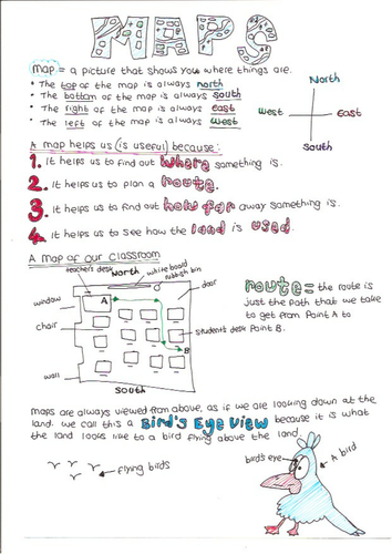
A hand drawn worksheet that I created for my Key Stage 2 geography students, in the former Soviet Republic of Georgia. Designed for students new to the British National Curriculum, and with English as a foreign language. Revision for maps, scale, bird's eye view, and features.
Please leave me a review and I will send you any other resource of your choice for free (contact me: office@oceansproject.com). Check out my other resources at my shop: https://www.tes.com/teaching-resources/shop/sarah277
Let me know if you have any resource requests and I will tailor make a resource for you.
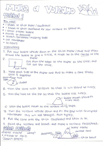
A hand drawn activity worksheet that I created for my geography students (of all ages) in the former Soviet Republic of Georgia. The activity was to make a volcano and a fact sheet about volcanoes in a group or on their own for their homework. There was a prize for the best ones, and we invited the rest of the school to come and see them in action. It went down very well indeed! It was a great way to finish off the term, with a fun activity after studying tectonics all year.
Please leave me a review and I will send you any other resource of your choice for free (contact me: office@oceansproject.com). Check out my other resources at my shop: https://www.tes.com/teaching-resources/shop/sarah277
Let me know if you have any resource requests and I will tailor make a resource for you.
A hand drawn mind map and revision worksheet that I created for my geography students whilst in the former Soviet Republic of Georgia. Designed for students with English as a foreign language, who had not been taught revision techniques or study skills necessary for taking IGCSE or British curriculum Key Stage tests and exams. Could be used in class, for homework, or for revision, or essay work. The Alps is used as the case study for fold mountain ranges.
Please leave me a review and I will send you any other resource of your choice for free (contact me: office@oceansproject.com). Check out my other resources at my shop: https://www.tes.com/teaching-resources/shop/sarah277
Let me know if you have any resource requests and I will tailor make a resource for you.
This was a really fun activity that I came up with for all of my geography classes (from Key Stage 2 to IGCSE) whilst teaching in the former Soviet Republic of Georgia. I had no idea whether the Queen (or her office!) would actually reply, but the students were delighted to receive a letter along with information about the Royal family, and of course a letter with the Buckingham Palace postal mark on it! This was hung in pride of place in the school entrance, much to the delight of visiting parents.
The activity is based on the National Curriculum for geography, and how to address an envelope, along with understanding the differences between country, county, postal code, and street name. But is equally beneficial as part of a literacy lesson, introducing yourself to a stranger, or for talking about the cultural differences, or being on holiday. For example, Georgia has no postmen or women, and there are no post boxes, whereas Britain has red post boxes, and our stamp has an image of the Queen’s head on it.
The worksheet itself is hand drawn as I had no resources in Georgia, other than access to a photocopier in the city. I hope you will enjoy this activity as much as we did. I sent each class’s letters in one envelope, we heard back a month or so later, mainly due to Georgia not really having a postal system at that time.
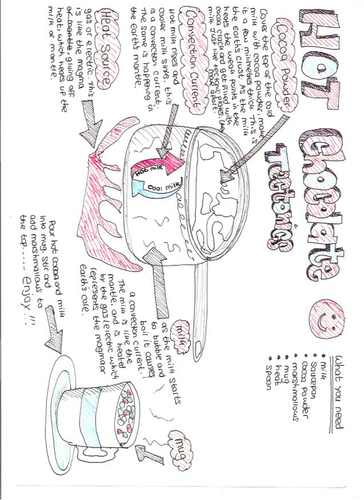
A fun and tasty activity to help students understand plate tectonics and convection currents. Created as a homework activity for my Key Stage 3 and iGCSE geography students in the former Soviet Republic of Georgia, who had English as a foreign language. Younger students may require supervision when making their hot chocolate. Could be a nice activity to do in class, or to cheer up their revision sessions. The worksheet is hand drawn.
Please leave me a review and I will send you any other resource of your choice for free (contact me: office@oceansproject.com). Check out my other resources at my shop: https://www.tes.com/teaching-resources/shop/sarah277
Let me know if you have any resource requests and I will tailor make a resource for you.
A hand drawn, revision mind map on the topic of earthquakes - what are they, how do they happen, and how are they measured. Created for my geography students in the former Soviet Republic of Georgia who were new to the iGCSE and had English as a foreign language. Could be used in class, as homework, as a refresher, or for exam revision.
A basic, hand drawn mind map on the topic of 'what do we use fold mountain areas for'. Created as a revision tool for students with English as a foreign language, in the former Soviet Republic of Georgia. Could be used in class, as homework, for end of term or exam revision.
Please leave me a review and I will send you any other resource of your choice for free (contact me: office@oceansproject.com). Check out my other resources at my shop: https://www.tes.com/teaching-resources/shop/sarah277
Let me know if you have any resource requests and I will tailor make a resource for you.