Thank you for visiting! Here you will find a selection of printable, interactive worksheets for your classroom: Basic Geography worksheets with simple maps, ESL, Spanish, Bible, Reading Comprehension and more. I hope you find the resources useful! Reviews are welcome and very much appreciated. Thank you so much.
Thank you for visiting! Here you will find a selection of printable, interactive worksheets for your classroom: Basic Geography worksheets with simple maps, ESL, Spanish, Bible, Reading Comprehension and more. I hope you find the resources useful! Reviews are welcome and very much appreciated. Thank you so much.
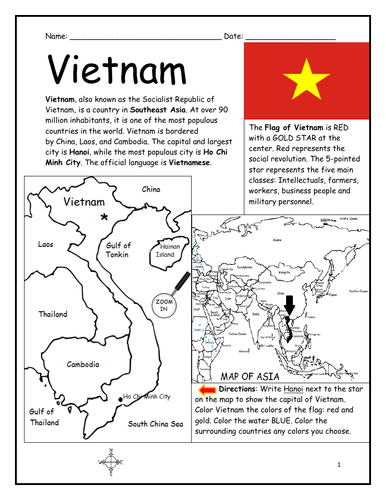
Introduce your students to VIETNAM with this printable handout of two worksheets (plus answer key). Your students will read a brief introduction to Vietnam (location, capital, flag, language), write 'Hanoi’ next to the star on the map to show the capital, color the small map of Vietnam and surrounding, and use the map and compass to answer 7 questions on page 2. Colored pencils and a pen or pencil are needed for this activity. No other prep needed. Basic Geography worksheet with a simple map to introduce Vietnam and practice cardinal and ordinal directions.
For use with Interactive Notebooks: After the worksheets are completed, students can cut out the map and flag and paste into the notebook under the topic of Asia/Sub-Topic: Vietnam. Under the map and flag, your students can write a summary in their own words of what they now know about Vietnam. Collect handouts for other countries of Asia to add to the notebook! All available in this store. Please browse this store for a selection of printable Geography worksheets for countries of Asia (and beyond!).
Thank you for using my Geography worksheets in your classroom! I hope you find them useful. Reviews are welcome and very much appreciated!
Introduce your learners to Ireland with this printable handout of two worksheets (plus answer key). Your students will read a brief overview of Ireland (location, capital, flag, language), write ‘Dublin’ next to the star on the map to show the location of the capital, color the small map and flag, and use the map and compass to answer 6 multiple-choice questions on page 2. Colored pencils or and a pen or pencil are needed for this activity. No other prep needed. Basic Geography worksheet with a simple map to introduce the country of Ireland.
For use with Interactive Notebooks: After completing the worksheets, students can cut out the map and flag and paste it into the notebook under the topic of Europe / Sub-Topic: Ireland. Under the map, students will write a summary in their own words of what they now know about this country. Collect worksheets for other countries of Europe to add to the notebook! Please browse this store for a selection of worksheets for other countries of Europe (and beyond!).
Thank you so much for using my Geography worksheets in your classroom! I hope you find them useful. Reviews are welcome and very much appreciated.
Introduce your students to Nicaragua with two printable worksheets (plus answer key). Your students will read a brief introduction to Nicaragua (location, capital, flag, language), write ‘Managua’ next to the star on the map to show the location of the capital, color the small flag and map, and use the map and compass to answer 7 questions on page 2. Colored pencils and a pen or pencil are needed for this activity. No other prep needed. Basic Geography worksheet with a simple map to introduce Nicaragua and practice cardinal and ordinal directions.
For use with Interactive Notebooks: After the worksheets are completed, students can cut out the map and flag and paste into the notebook under the topic of Central America (or Spanish-speaking countries) /Sub-Topic: Nicaragua. Under the map and flag, students can write a summary in their own words of what they now know about this country. Collect worksheets for other countries of Central America to add to the notebook! Please browse this store for a selection of printable handouts for other countries of Central America (and beyond!)
Thank you so much for using my Geography worksheets in your classroom! I hope you find them useful. Reviews are welcome and very much appreciated! Please browse this store for worksheets to introduce your students to the countries of the world!
This printable handout includes a Spanish Pronunciation Quick Guide for vowels and consonants with 5 words and pictures to practice. Directions: Use the Spanish Pronunciation Guide on the left to pronounce the words on the right.
Words/Pictures included in Spanish:
chicken - la gallina
frog - la rana
carrot - la zanahoria
hammer - el martillo
bathtub - la bañera
This is a great activity to prepare your students to increase their Spanish vocabulary. From here, your students can begin creating their own Spanish Picture Dictionary and continue to expand vocabulary with use of this pronunciation guide. For more information, please visit ‘My Spanish Picture Dictionary’ https://www.tes.com/teaching-resource/my-spanish-picture-dictionary-11829384 in my shop.
Thank you so much!!
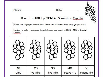
Teach your students how to count to 100 by TEN in Spanish with this packet of printable handouts. Colored pencils and a pen or pencil are needed for this activity.
Page 1: There are 10 grapes in 10 boxes. Each box is numbered by tens in Spanish. Directions for student: Number and/or color the grapes in each box.
Page 2: Write the word in Spanish (10, 20, 30, 40, 50)
Page 3: Write the word in Spanish - Page 2 (60, 70, 80, 90, 100)
Page 4: Match the word in Spanish with the correct number. Then check your own
answers using your coloring page.
Page 5: Word Search: Find each word in Spanish.
Page 6: Fill in the blank.
Page 7: Quiz: Write the correct word in Spanish next to each number.
Page 8: Answer Key.
Introduce your students to Mexico with two printable worksheets (plus answer key). Your students will read a brief introduction to Mexico (location, capital, flag, language), write ‘Mexico City’ next to the star on the map to show the location of the capital, write ‘U.S.’ in each state of the United States, write ‘C.A.’ in each country of Central America, color the map and flag of Mexico, and use the map and compass to answer 7 questions on page 2. Colored pencils and a pen or pencil are needed for this activity. No other prep needed. Basic Geography worksheet with a simple map to introduce Mexico and practice cardinal and ordinal directions.
For use with Interactive Notebooks: After the worksheets are completed, students can cut out the map and flag and paste into the notebook under the topic of (example): Spanish-Speaking Countries / Sub-Topic: Mexico. Under the map, your students can write a summary in their own words of what they now know about this country. Collect worksheets for other Spanish-speaking countries to add to the notebook! All available in this store!
Thank you so much for using my worksheets in your classroom! I hope you find them useful. Reviews are welcome and very much appreciated! Please browse this store for a selection of worksheets to introduce your learners to the countries of the world!
Find the books of the Old Testament in the Word Search Puzzle. They can be found forward or backward. After all the books are found, write the remaining letters on the lines below for the bible verse.
Bible verse: When I am afraid, I will put my trust in you. Psalm 56:3.
Books of the Old Testament:
Genesis, Exodus, Leviticus, Numbers, Deuteronomy, Joshua, Judges, Ruth, 1 Samuel, 2 Samuel, 1 Kings, 2 Kings, 1 Chronicles, 2 Chronicles, Ezra, Nehemiah, Esther, Job, Psalms, Proverbs, Ecclesiastes, Song of Solomon, Isaiah, Jeremiah, Lamentations, Ezekiel, Daniel, Hosea, Joel, Amos, Obadiah, Jonah, Micah, Nahum, Habakkuk, Zephaniah, Haggai, Zechariah, Malachi
Introduce your students to Uganda with two worksheets (plus answer key). Your students will read a brief introduction to Uganda (location, capital, flag, language), write ‘Kampala’ next to the star on the map to show the location of the capital, color the small map, and use the map and compass to answer 8 questions on page 2. Colored pencils and a pen or pencil are needed for this activity. No other prep needed. Basic Geography worksheet with a simple map to introduce the country of Uganda and practice cardinal/ordinal directions.
For use with Interactive Notebooks: After the worksheets are completed, students can cut out the map and flag and paste into the notebook under the topic of Africa / Sub-topic: Uganda. Under the map and flag, your students can write a summary in their own words of what they now know about this country. Collect worksheets for other countries of Africa to add to the notebook! Please browse this store for a selection of worksheets for other countries of Africa (and beyond!).
Thank you so much for using my Geography worksheets in your classroom! I hope you find them useful. Reviews are welcome and very much appreciated!
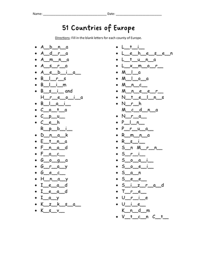
Do your students know all 51 countries of Europe? With this printable activity, your students will fill in the blank letters for each country of Europe! One printable worksheet plus answer key that includes the list of countries in alphabetical order. Print and go!
List of countries included: Albania, Andorra, Armenia, Austria, Azerbaijan, Belarus, Belgium, Bosnia and Herzegovina, Bulgaria, Croatia, Cyprus, Czech Republic, Denmark, Estonia, Finland, France, Georgia, Germany, Greece, Hungary, Iceland, Ireland, Italy, Kazakhstan, Kosovo, Latvia, Lithuania, Luxembourg, Macedonia, Malta, Moldova, Monaco, Montenegro, Netherlands, Norway, Poland, Portugal, Romania, Russia, San Marino, Serbia, Slovakia, Slovenia, Spain, Sweden, Switzerland, Turkey, Ukraine, United Kingdom, Vatican City.
Introduce your learners to each country of Europe one country at a time with a printable worksheet for each country! Each country includes a simple map activity and reading comprehension activities. All available in this store!
Thank you so much for using my worksheets in your classroom! I hope you find them useful. Reviews are welcome and very much appreciated! Please browse this store for more printable worksheets to introduce your learners to the countries of the world!
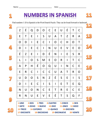
Find numbers 1-20 in Spanish in this Word Search Puzzle. They can be found forward or backward. 1 printable handout. Includes: uno, dos, tres, cuatro, cinco, seis, siete, ocho, nueve, diez, once, doce, trece, catorce, quince, dieciséis, diecisiete, dieciocho, diecinueve, veinte.
For numbers 1-20 in English, please visit: ENGLISH NUMBERS 1-20 WORD SEARCH PUZZLE.
Thanks so much for using my handouts in your classroom! I hope you find them useful. Reviews are welcome and very much appreciated. Please follow this store for more printables.
Teach your students the countries of Central America with this printable handout (2 worksheets plus answer key). Students will read a brief overview of Central America, write the capital next to the star of each country, write NORTH AMERICA on the upper left side of the map and SOUTH AMERICA on the lower right, color the map, then answer the questions that follow.
Colored pencils and a pen or pencil are needed for this activity. No other prep needed. This printable handout can be used after the handouts of each individual country of Central America are complete (Belize, Guatemala, Honduras, El Salvador, Nicaragua, Costa Rica, Panama) or on its own.
Thank you for using my printable handouts in your classroom! I hope you find them useful. Reviews are welcome and very much appreciated.
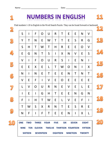
Find the words in English for numbers 1-20 in the Word Search Puzzle. They can be found forward or backward. Printable handout of 1 page.
Thank you for using my handouts in your classroom to teach English! I hope you find them useful. Reviews are welcome and very much appreciated. Please Follow This Store for more handouts.
Happy Teaching!
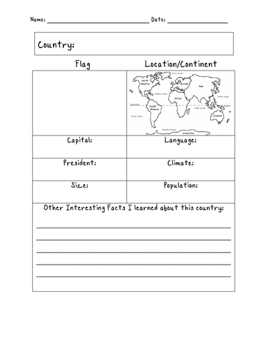
Assign a country or have your students choose a country to learn about on their own. With this printable blank ‘Country Fact Sheet,’ your students will write the name of the assigned country, find the location of that country on the map of the 7 continents, write the country’s capital, language, president, climate, size, population, and list any other interesting facts they learned in their research.
Great for homework and independent study.
Thank you so much for using my printable handouts in your classroom! I hope you find them useful. Reviews are welcome and very much appreciated! Please browse this store for more worksheets to introduce your learners to the countries of the world!
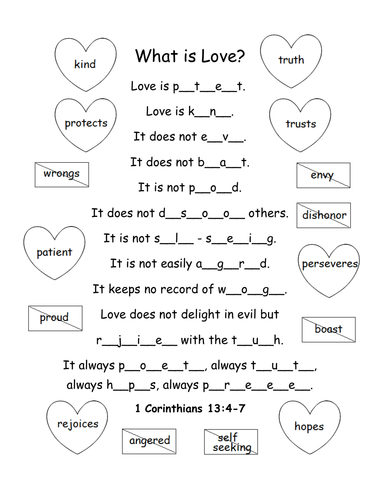
Printable activity/coloring page for 1 Corinthians 13:4-7. What is love? Fill in the blank letters for each word to complete the bible verse.
Love is patient, love is kind. It does not envy, it does not boast, it is not proud. It does not dishonor others, it is not self-seeking, it is not easily angered, it keeps no record of wrongs. Love does not delight in evil but rejoices with the truth. It always protects, always trusts, always hopes, always perseveres.
1 Corinthians 13:4-7 (NIV)
Thank you so much! God bless!
Introduce your learners to Cuba with this printable handout of 2 worksheets (plus answer key). Your students will read a brief introduction to Cuba (location, capital, flag), write ‘Havana’ next to the star on the map to show the location of the capital, color color the flag and map of Cuba, then use the map and compass to answer 5 multiple-choice questions on page 2. Colored pencils and a pen or pencil are needed for this activity. No other prep needed. Basic Geography worksheet with a simple map to introduce Cuba and practice cardinal and ordinal directions.
For use with Interactive Notebooks: After the worksheets are completed, students can cut out the map and flag and paste into the notebook under the topic of Caribbean / Sub-topic: CUBA. Under the map, your students can write a summary in their own words of what they now know about Cuba. Collect worksheets for other countries to add to the notebook! Please browse this store for a selection of worksheets for other countries of the Caribbean (and beyond!).
Thank you so much for using my Geography worksheets in your classroom! I hope you find them useful. Reviews are welcome and very much appreciated!
Cuba and surrounding: Jamaica, Haiti, Dominican Republic, Mexico, Belize, Guatemala, Honduras, United States, Florida, the Bahamas, Caribbean Sea, Atlantic Ocean, Gulf of Mexico. North America, Central America. Cardinal, ordinal directions. Isla de la Juventud.
Note: This handout is in American English. For British English, please visit this link: https://www.tes.com/teaching-resource/cuba-printable-handout-british-english-11997673
Color and learn the map of Asia with this printable coloring page. Colored pencils or crayons are needed for this activity. No other prep needed.
Countries included: Afghanistan, Armenia, Azerbaijan, Bahrain, Bangladesh, Bhutan, Brunei, Cambodia, China, Cyprus, Georgia, India, Indonesia, Iran, Iraq, Israel, Japan, Jordan, Kazakhstan, Kuwait, Kyrgyzstan, Laos, Lebanon, Malaysia, Maldives, Mongolia, Myanmar, Nepal, North Korea, Oman, Pakistan, Palestine, Philippines, Qatar, Russia, Saudi Arabia, Singapore, South Korea, Sri Lanka, Syria, Taiwan, Tajikistan, Thailand, Timor-Leste, Turkey, Turkmenistan, UAE (United Arab Emirates) , Uzbekistan, Vietnam, and Yemen. Also the Arctic Ocean, Pacific Ocean, Indian Ocean and surrounding parts of Europe and Africa.
Thank you for using my Geography worksheets and coloring pages!
Assign a state or have your students choose a state to learn about on their own. With this printable blank ‘State Fact Sheet,’ your students will write the name of the assigned state, find the location of that state on the map of the United States, fill in the state capital, state abbreviation, state governor, state flag, state bird, state flower, and list any other interesting facts they learned in their research.
Introduce your students to the countries and capitals of South America! This printable handout of 4 pages includes a list of the 12 countries and capitals and the 3 dependent territories and capitals of South America. Your students will read a brief introduction to South America, write the capital of each country on the map, color the map, and answer the questions that follow. Answer key included.
For worksheets for each country of South America, please check out this discounted bundle: https://www.tes.com/teaching-resource/resource-12525113
Thank you so much for using my Geography worksheets in your classroom! I hope you find them useful. Reviews are welcome and very much appreciated!
Printable handout of the map of the United States. Write the name of each state on the map (the first letter of each state is listed on the map as clues). Answer key included.
Introduce your learners to the GREAT LAKES of North America with this printable handout of two worksheets (plus answer key). Your students will write the names of the 5 Great Lakes on the map, color the map (Great Lakes, Canada, United States) and use the map to answer 9 questions on page 2.
Included on this map: Lake Superior; Lake Michigan; Lake Huron; Lake Erie; Lake Ontario; Canada Provinces Ontario and Quebec; US States: Minnesota; Wisconsin; Iowa; Illinois; Indiana; Michigan; Ohio; Pennsylvania; New York.
Thank you for using my Geography worksheets! Please browse this store for a selection of printable Geography worksheets for North America and beyond.