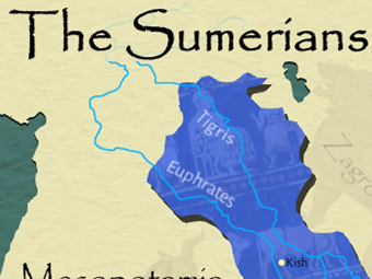


Bring the world’s first civilisation to life with this Ancient Sumer Map Pack, designed to support KS2 lessons on early civilisations in Mesopotamia. These clear, child-friendly maps help pupils understand where Sumer was located, how it fits into Mesopotamia, and its wider geographical context.
What’s Included:
✔ Highly detailed colour map of Sumer (2100 BC) – perfect for teaching and display.
✔ Jigsaw map activity – engaging puzzle to help pupils build geographical awareness.
✔ Label-the-map worksheet – reinforces knowledge of Sumerian territory and cities.
✔ Blank outline map of Sumer – for independent labelling and retrieval practice.
✔ Blank map of Mesopotamia – shows the wider region and context.
✔ Blank Middle East map – ideal for cross-curricular geography or comparing ancient empires.
Something went wrong, please try again later.
This resource hasn't been reviewed yet
To ensure quality for our reviews, only customers who have purchased this resource can review it
Report this resourceto let us know if it violates our terms and conditions.
Our customer service team will review your report and will be in touch.
£2.00