
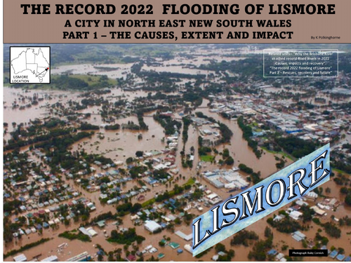
Natural disasters such as cyclones, bush fires and droughts affect Australia. In 2022 (March-April) the East Coast of Australia experienced intense and prolonged periods of rain. Coastal rivers over-banked. Towns were flooded. Roads were closed and residents were forced to evacuate. Lismore in the North-East of New South Wales was one of the most affected towns. This unit looks at reasons for the flooding. Maps show the extent of the flooding. Photographs reveal the impact of the flooding. For the residents of low-lying areas of Lismore past floods have occurred in the recent past. However, the floods (the were 2) of
February-March-April broke previous records in terms of height and impact.
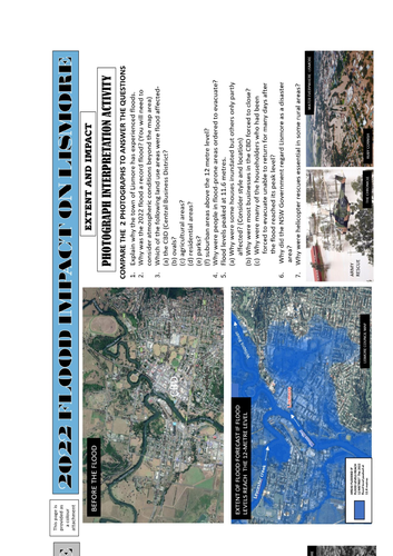
This unit looks at causes, extent and impact. Use the photographs to gain a level of understanding. Find out why the residents and business owners have been particularly frustrated by the floods. Understand why some may decide to leave the area after the second flood. Use the attachment to add to student understanding. This unit links closely with the second unit dealing with rescue, recovery, clean-up and uncertain future. The Lismore story is yet to be completed by future changes.
Something went wrong, please try again later.
So great to see a resource made so students can understand how catastrophic flooding occurs. However the flood of 28 Feb 2022 reached 14.4m (not the 11.6m stated), and the creek on slide 4 is spelled Leycester not Laycaster. This page has some great info images and resources... http://australiasevereweather.com/floods/lismore_flood_pictures_reports.htm
Report this resourceto let us know if it violates our terms and conditions.
Our customer service team will review your report and will be in touch.
£0.00