Investigating Rivers is a Geography unit suitable for KS2 (Y4-6).
The planning overview and topic title page can be downloaded for free here. Lessons include:
L1 - Understanding the water cycle
L2 - Identifying features of a river system
L3 - Identifying characteristics of the three stages of a river
L4 - Investigating features of the River Thames
L5 - Thinking about the different ways we use water
L6 - Understanding the impacts of floods and droughts
Each lesson includes a presentation and differentiated activities/worksheets.
If you like this resource, we would appreciate a review! We will happily send you a free resource in return for a review or useful suggestions/feedback. Contact us at ed@teachitforward.co.uk.
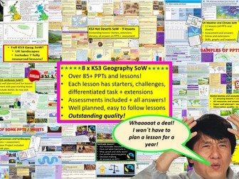
GET ALL OF MY PAID KS3 RESOURCES FOR JUST £13.99!!!
85+ lessons for under £14 or less than 15p a lesson… Bargain!
**Eight Key Stage 3 Schemes of work, enough teaching content for almost two years! **
All of my lessons are well planned, engaging, differentiated and fun! Download one of my free ones if you aren´t sure and try before you buy!
The following 8 Schemes of work are included WITH assessments:
World biomes (11 lessons)
• Lesson 1: Ecosystems
• Lesson 2: Food webs
• Lesson 3: Global biomes introduction
• Lesson 4: Mediterranean biome
• Lesson 5: Coral Reefs
• Lesson 6: Bamboo forests
• Lesson 7: Tropical Rainforests
• Lesson 8: Hot deserts
• Lesson 9: Polar biomes
• Lesson 10: Assessment lesson
• Lesson 11: Peer feedback/marking lesson
River landscapes of the UK (7 lessons)
• Lesson 1: Where are the UK’s rivers?
• Lesson 2: What are the UK’s rivers like?
• Lesson 3: What processes happen inside a river?
• Lesson 4: How do waterfalls form?
• Lesson 5: Meanders… they’re forever changing
• Lesson 6: The Landforms of the Lower Course
• Lesson 7: The Somerset levels floods 2014
• Lesson 8: How can we our manage rivers?
• Lesson 9: Rivers Assessment lesson
Weather and climate of the UK (9 lessons)
• Lesson 1: What is weather and climate?
• Lesson 2: Recording the Weather
• Lesson 3: Who cares about the weather?
• Lesson 4: Where does the UK’s weather come from?
• Lesson 5: The Beast from the East
• Lesson 6: How can the UK use it’s wind?
• Lesson 7: Does the UK need so much rain?
• Lesson 8: What are Urban Micro climates and how do they affect London?
• Lesson 9: Assessment and feedback
Tropical Rainforests (12 lessons)
• Lesson 1: What and where are our rainforests?
• Lesson 2: What is the structure of the Rainforests?
• Lesson 3: What is the climate like in the Rainforest?
• Lesson 4: How are plants and animals adapted to the rainforest?
• Lesson 5: How do we benefit from the Rainforest?
• Lesson 6: What is Deforestation?
• Lesson 7: What are the effects of Deforestation?
• Lesson 8: How can we use the rainforest sustainably?
• Lesson 9: Saving the Rainforest!
• Lesson 10: Assessment lesson
• Lesson 11: Assessment feedback and peer marking lesson.
• Lesson 12: Extended project: Researching a rainforest.
UK landscapes and processes (7 lessons)
• Lesson 1: introduction to UK landscapes
• Lesson 2: How does geology shape the UK?
• Lesson 3: Chemical weathering and limestone plateaus
• Lesson 4: Mountains in the UK: Their birth and erosion
• Lesson 5: Forests in the UK
• Lesson 6: Map reading and tourist developments in the lake district.
• Lesson 7: Assessment lesson with feedback PPT.
Polar biomes & environments (11 lessons)
Lesson 1 - Polar Environments, what are they and where they
Lesson 2 - Polar biomes climate graph
Lesson 3 - How have some plants and animals adapted to live in The Arctic
Lesson 4 - The threats to Polar biomes
Lesson 5 - How fast are polar biomes warming
Lesson 6 - Tourism in polar biomes
Lesson 7 - The Antarctic treaty
Lesson 8 - Should we mine Antartica
Lesson 9 - Map reading in Polar biomes
Lesson 10 - Assessment lesson
Lesson 11 - Assessment feedback & peer marking
Hot deserts (9 lessons)
Lesson 1: What is a hot desert and where are they found?
Lesson 2: Drawing a climate graph for hot deserts
Lesson 3: How can animals and plants survive in hot deserts?
Lesson 4: What is desertification and why is it happening?
Lesson 5: Can desertification be stopped?
Lesson 6: Tourism in a hot desert far far away…
Lesson 7: Can you navigate through a hot desert?
Lesson 8: Assessment lesson
Lesson 9: Peer marking and assessment feedback
Globalisation 12 lessons
Lesson 1: An introduction to globalisation
Lesson 2: How has globalisation happned?
Lesson 3: Why do companies go global? Mcdonalds
Lesson 4: What is a TNC and why do they work in so many countries?
Lesson 5: The pros and cons of globalisation
Lesson 6: The dark side of globalisation
Lesson 7: A TNC in Nigeria: Shell
Lesson 8: How is globalisation helpful? NGOs
Lesson 9: IGOs: WHO will stop Malaria?
Lesson 10: Assessment lesson
Lesson 11: Peer marking and assessment feedback
Lesson 12: Optional project on a TNC
Interplanetary population project
extras (wordsearches, extensions, games mapping, Halloween mapping…)
This includes ALL of my lessons, quizzes, and six full schemes of work with over 75 lessons in total!!!
(some stand alone lessons are omitted as they are repeated/included in SoW)
Please check out all of my FREE school resources and Geography lessons on my shop where you´ll also find full schemes of work for just £3 and lots of other useful resources��� Or purchase all of my KS3 resources for just £13.99!
I would really appreciate it if you could leave me a review, thanks!
https://www.tes.com/teaching-resources/shop/ukjoshkelly94
Questions or issues: ukjoshkelly@yahoo.co.uk
Mountain Environments is a Geography unit suitable for KS2 (Y4-6) and has everything you need for covering a mountains topic.
The planning overview, topic title page and vocabulary page can be downloaded for free here. Lessons include:
L1 – Identifying the key features of mountains
L2 – Identifying the world’s major mountain ranges
L3 – Locating the world’s famous mountains using latitude and longitude
L4 – Understanding how fold mountains are formed
L5 – Investigating the structure of a volcano (FREE)
L6 – Researching famous world mountains (FREE)
L7 – Investigating mountain climates
Each lesson includes a presentation and differentiated activities/worksheets.
If you like this resource, we would appreciate a review! We will happily send you a free resource in return for a review or useful suggestions/feedback. Contact us at ed@teachitforward.co.uk.
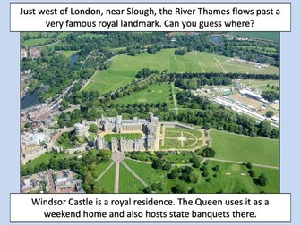
This lesson is part of Investigating Rivers, a unit designed for upper KS2 (Y4-6).
The presentation takes students on a journey from the source to the mouth of the River Thames. Starting at Thames Head, the source of the River Thames, students investigate maps and satellite photos and try to identify river features along the way. Other locations include Windsor Castle, the Isle of Dogs in London and the mouth of the river at Southend-on-Sea.
The writing-based activity challenges students to first label each map/satellite photo and then write a paragraph describing the location and river features they can see. It is differentiated two ways:
Easier – Students have maps/satellite photos and cloze procedure paragraphs to complete.
Harder – Students have maps/satellite photos, a wordbank and write their own paragraphs.
If you like this resource, we would appreciate a review! We will happily send you a free resource in return for a review or useful suggestions/feedback. Contact us at ed@teachitforward.co.uk.
This lesson is designed for KS2 students. It can be taught as a stand alone lesson but is also available as part of two wider units, both of which are available on TES:
-Volcanoes
-Volcanoes & Earthquakes
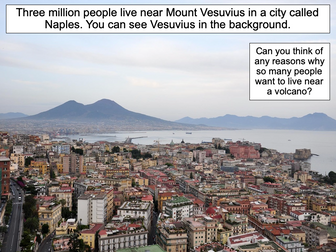
First the presentation looks at Mount Etna and Mount Vesuvius in Italy and asks why people choose to live so close to volcanoes.
The activities then challenges students to think about the advantages and disadvantages of living near a volcano:
Partner Activity:
Students sort statements and photos into advantages and disadvantages of living near a volcano.
Writing Activity:
Students write about the advantages and disadvantages of living near a volcano. Stickers and a vocabulary prompt are provided for this activity.
If you like this resource, we would appreciate a review! We will happily send you a free resource in return for a review or useful suggestions/feedback. Contact us at ed@teachitforward.co.uk.
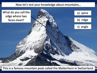
This is the first lesson in Mountain Environments, a Geography unit designed for students in upper KS2 (Y4-6).
First the presentation introduces students to the topic and looks at some of the activities people do in mountains. It then introduces the key features of a mountain range.
The activity challenges students to identify the key features of a mountain environment. It is differentiated three ways:
Easier – Students identify 8 key features of mountains.
Medium – Students identify 10 key features of mountains.
Harder – Students label the key features of mountains in their exercise book.
Extension – Students match mountain vocabulary to their definitions.
If you like this resource, we would appreciate a review! We will happily send you a free resource in return for a review or useful suggestions/feedback. Contact us at ed@teachitforward.co.uk.
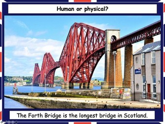
This lesson is part of Exploring the United Kingdom, a Geography unit designed for KS1 and lower KS2 (Y2-4).
The presentation helps students understand the difference between human and physical geographical features. It then challenges them to classify famous UK landmarks as either human or physical.
There are two engaging activities included:
Partner activity:
Students sort pictures/descriptions of UK landmarks into human and physical geographical features.
Individual activity:
Students match pictures of UK landmarks to their descriptions. This is differentiated three ways:
Easier – Students match 8 features to their descriptions.
Medium – Students match 12 features to their descriptions.
Harder – Students write a description of each UK landmark using a word bank.
Extension – Students sort the UK landmarks into human and physical geographical features.
If you like this resource, we would appreciate a review! We will happily send you a free resource in return for a review or useful suggestions/feedback. Contact us at ed@teachitforward.co.uk.
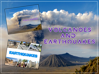
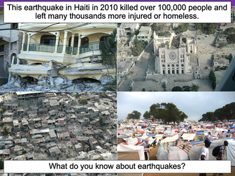
Volcanoes & Earthquakes is an exciting extended Geography unit designed for students in KS2.
The planning overview, topic title page and vocabulary page can be downloaded for free here. Lessons include:
L1 – Understanding the structure of the Earth
L2 – Investigating the structure of a volcano (FREE)
L3 – Locating the world’s famous volcanoes
L4 – Investigating the five deadly features of a volcanic eruption
L5 – Understanding tectonic plates
L6 – Exploring the effects of volcanic eruptions on Montserrat
L7 – Why do people live near volcanoes?
L8 – Understanding the causes of earthquakes
L9 – Investigating the five deadly features of an earthquake
L10 – Researching earthquakes using Wikipedia
L11 – Locating the world’s biggest earthquakes using latitude & longitude
L12 – Writing a fact file about a famous earthquake
Each lesson includes a presentation and differentiated activities/worksheets.
A FREE newspaper report template is also included in this unit.
If you like this resource, we would appreciate a review! We will happily send you a free resource in return for a review or useful suggestions/feedback. Contact us at ed@teachitforward.co.uk.
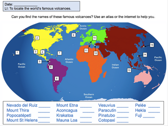
This lesson is designed for KS2 students. It can be taught as a stand alone lesson but is also available as part of two wider units, both of which are available on TES:
-Volcanoes
-Volcanoes & Earthquakes
First the presentation introduces some of the world’s most famous volcanoes and classes them as active, dormant or extinct.
The activity then challenges students to locate volcanoes using an atlas or the internet (e.g. Google maps). Alternatively, a map of famous world volcanoes is also provided.
Easier – Students locate volcanoes using the map of famous volcanoes (writing numbers).
Medium – Students locate volcanoes using the map of famous volcanoes (writing volcano names).
Harder – Students locate volcanoes using an atlas.
(N.B. It is recommended you check the atlas has the relevant maps prior doing the activity.)
If you like this resource, we would appreciate a review! We will happily send you a free resource in return for a review or useful suggestions/feedback. Contact us at ed@teachitforward.co.uk.
Full unit of work for tourism. All lesson are suitable for 50 minutes to 1 hour of teaching time. Includes supporting worksheets for lessons - no additional resources are required. Homework’s integrated into lessons where appropriate.
Most suitable for KS3 geography.
All lessons have a starter and lesson objectives. All PowerPoints in the same style.
Lesson sequence:
1 - What is tourism?
2 - The growth of tourism
3 - What attracts tourists to different destination?
4 - British tourism
5 - What are the impacts of tourism in National Parks?
6 - Declining tourism in Britain
7 - History and tourism
8 - The impact of tourism
9 - Jobs in the tourist industry
10 - Ski resorts
11 - Tourism in Kenya
12 - Sustainable tourism
13 - Sustainable tourism in Peru
14 - Does tourism cause conflict?
For more resources visit This is Geography. Full SoW for all new GCSE specifications - AQA, Edexcel, OCR, CIE IGCSE, Edexcel IGCSE and Eduqas. As well as over 200 lessons for KS3 and KS2. Want something bespoke designing? Email us for further details info@thisisgeography.co.uk
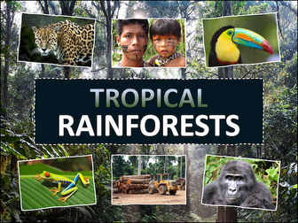
Tropical Rainforests is a Geography unit designed for students in KS2 (Y3-6).
The planning overview, topic title page and a knowledge organiser can be downloaded for free here. Lessons include:
L1 – Locating tropical rainforests on a world map
L2 – Identifying tropical rainforest animals
L3 – Investigating the layers of a tropical rainforest
L4 – Exploring the Amazon rainforest
L5 – Understanding the impact of deforestation on the Amazon
L6 – Investigating how deforestation affects an Amazon tribe
L7 - Thinking of ways to help save tropical rainforests
Each lesson includes a presentation and differentiated activities/worksheets. A knowledge organiser is also included. All resources are compatible with both Microsoft Office and Google Workspace.
If you like this resource, we would appreciate a review! We will happily send you a free resource in return for a review or useful suggestions/feedback. Contact us at ed@teachitforward.co.uk.
This lesson is designed for KS2 children. It can be taught as a stand alone lesson but is also available as part of two wider units, both of which are available on TES:
-Earthquakes
-Volcanoes & Earthquakes
First the presentation looks at how the Earth’s crust is split into tectonic plates. It then examines the causes of earthquakes, how they occur at the fault lines between tectonic plates and what the hypocentre and epicentre of an earthquake are.
There are three different activities to choose from which can be done in Geography and/or Literacy lessons. These include:
Quiz Activity
Students watch a video clip about earthquakes and answer comprehension questions about it. This is differentiated two ways.
Cloze Procedure Activity
Students fill in the blanks in an explanation text about earthquakes. This is differentiated two ways.
Writing Activity
Student write an explanation text about earthquakes. This is differentiated three ways and comes with vocabulary and sentence starter prompts.
If you like this resource, we would appreciate a review! We will happily send you a free resource in return for a review or useful suggestions/feedback. Contact us at ed@teachitforward.co.uk.
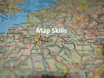
Full unit of work for map skills. All lesson are suitable for 50 minutes to 1 hour of teaching time. Includes supporting worksheets for lessons - no additional resources are required. Develops core skills for geography students in KS3 or high ability KS2.
All lessons have a starter and lesson objectives. All PowerPoints in the same signature style.
Lesson sequence:
1 - Introduction to maps
2 - Where is the UK?
3 - Compass points
4 - Map symbols
5 - 4 and 6 figure grid references
6 - Scale and distance
7 - Atlas skills
8 - Height and relief
9 - Longitude and latitude
10 - Design your own treasure map
11 - Mapzone GIS
Also includes Types of Geography lesson (can be used as an introduction lesson for Y7), Geography Literacy mat and Geography Numeracy/Map Skills mat.
Homeworks - 3 x countries and capitals test sheets to develop global place knowledge
For more resources visit This is Geography. Full SoW for all new GCSE specifications - AQA, Edexcel, OCR, CIE IGCSE, Edexcel IGCSE and Eduqas. As well as over 200 lessons for KS3 and KS2. Want something bespoke designing? Email us for further details info@thisisgeography.co.uk
Understanding Trade is a Geography unit suitable for upper KS2 (Y5-6) and is a great way to teach students about global trade.
The planning overview, topic title page and vocabulary page can be downloaded for free here. Lessons include:
L1 – Investigating where the products we buy come from
L2 – Understanding that all products have a supply chain
L3 – Exploring the chocolate supply chain
L4 – Investigating the UK’s biggest exports
L5 – Investigating the highest value exports of different countries
L6 – Is the banana trade fair? (FREE)
Each lesson includes a presentation and differentiated activities/worksheets.
If you like this resource, we would appreciate a review! We will happily send you a free resource in return for a review or useful suggestions/feedback. Contact us at ed@teachitforward.co.uk.
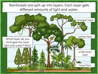
This lesson is part of Tropical Rainforests, a Geography unit designed for students in KS2, but can also be taught as a stand alone lesson. All resources are compatible with both Microsoft Office and Google Workspace.
First, the presentation introduces students to the different layers of the rainforest and some of the animals that live in each layer.
Students then complete a range of activities:
Activity 1:
In pairs, students match the layers of a tropical rainforest to descriptions.
Easier - Students have multicoloured descriptions. They match each layer to one green, blue and purple description.
Harder - Students have plain black descriptions. They match each layer to three other descriptions.
Activity 2:
Students identify and label the four layers of a tropical rainforest.
Easier - Students write one word for each layer.
Harder - Students write two words for each layer.
Extension:
Students cut out pictures of tropical rainforest animals and stick them in the layer in which they live.
If you like this resource, we would appreciate a review! We will happily send you a free resource in return for a review or useful suggestions/feedback. Contact us at ed@teachitforward.co.uk.
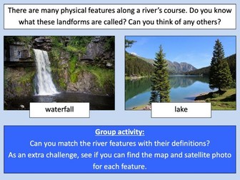
This lesson is part of Investigating Rivers, a unit designed for upper KS2 (Y4-6).
It introduces many key river concepts and a wide range of related vocabulary. First the presentation recaps the main processes of the water cycle. It then introduces some of the well known features of river systems (e.g. waterfalls and lakes). There are two activities:
Group Activity:
Students are challenged to match eight features of river systems to photos, satellite images and maps. This activity can easily be differentiated by giving groups different numbers of cards.
Individual Activity:
In the worksheet activity students identify the same features on a simplified drawing of a river system. It is differentiated two ways:
Easier – Students identify river features and complete cloze procedure definitions.
Harder – Students identify river features and write their own definitions of four river features.
If you like this resource, we would appreciate a review! We will happily send you a free resource in return for a review or useful suggestions/feedback. Contact us at ed@teachitforward.co.uk.
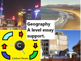
A collection of essays to support revision & teaching of the new AQA Geography A level.
This download contains a collection of eighteen model answers as well as some shorter answer questions and support activities. Marks schemes have been used to help ensure model answers access the higher band for each question. These create excellent support resources for your teaching of the new AQA Geography A level and will save you many hours in preparation time.
These essays would also support the teaching of other A level Geography specifications.
Essays included:
0 3 . 4 “Flooding and erosion is set to increase to unprecedented levels along coastlines
across the world. In response, mitigation and adaptation by coastal managers will
ensure that people and places are not affected.”
03.4 Assess the relative importance of weathering and erosion in the development of coastal landscapes. (20)
Assess the extent to which predicted climate change will present challenges for sustainable management of a local scale environment that you have studied. (20 marks).
“Human activity affects coasts globally. This interference with coastal processes is the key determining factor in shaping coastal landscapes.” To what extent do you agree with this opinion? (20 marks)
026 ‘Sustainable approaches to coastal management will become more important than traditional approaches in dealing with the impacts of climate change.’ 20 marks
Explain the formation of a saltmarsh environment. (4 marks)
Assess the role of vegetation in the development of a sand dune landscape. (6 marks)
Camber Sands teaching resource.
To what extent do the advantages of globalisation outweigh the disadvantages? [20] (or 25 marks under WJEC)
Transnational corporations (TNCs) are the most significant factor in creating unequal flows of people and money within global systems.’ 20 marks.
Analyse the roles of international government organisations and NGOs in the governance of Antarctica and assess their effectiveness. 20 marks
01.4 Assess the potential cause and impacts of changes in the water balance within a tropical rainforest that you have studied. 20 marks
Assess the extent to which rising global temperatures may result in a positive feedback cycle of yet higher carbon content in the atmosphere. (20 marks)
With reference to a river catchment that you have studied, assess the potential impact of human activity upon the drainage basin. (20 marks)
Assess the extent to which there are interrelationships between processes in water cycle and factors driving change in the carbon cycle. (20 marks)
With reference to a local scale of a specific place in a hazardous setting, assess the extent to which the physical nature of hazards can shape the character of a community and its ability to respond to risk. (20 marks)
To what extent have global institutions helped to promote growth and stability within global systems? (20 marks)
To what extent can wildfires be caused, intensified and mitigated by human activity? 20 marks.
‘The Disaster Response Curve (The Park Model) has contributed to improved understanding and therefore management of the impact of tectonic hazards.’
To what extent do you agree with this view? [20 marks]
An additional AS short essay:
Assess the extent that coastlines of submergence are created by sea level change. (9 Marks)
In this activity, the pupils learn the difference between the British Isles, Great Britain and the United Kingdom. They then go on to use an atlas to help them name the major countries, cities and seas in the UK. It makes for a good lesson when learning about the geography of the UK.
Very simple Year 7 introduction to the subject of Geography; helping students differentiate between physical, human, and environmental Geography issues.
Containing:Do now taskStarter taskMind-map taskMini plenaryPlenary
Also see:
My TES shop for all other resources.
Worksheets based on Wayland's Popcorn series Where I Live - 4 books that introduce how children live in different places in the UK. A photocopiable worksheet focuses on each place. Covers topics such as How does where you live change what you can do?, What is the local area like in a city, a village, by the seaside on in an island home? The books can be used for literacy, as they feature many examples of report text. Order copies of these books now at www.waylandbooks.co.uk and get 10% discount! Please enter promotional code DOWNLOAD10 at checkout to receive your discount.
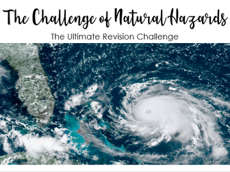
Three A3 Pages of Revision Recall of AQA GCSE Geography Paper 1 - The Challenge of Natural Hazards. A variety of tasks using icons including gap fills, image analysis, case study recall, true or false, formation of tropical storms. Feel free to edit according to your case studies
 Quick View