Urbanisation: An Increasingly Urban WorldQuick View
markthegeographer

Urbanisation: An Increasingly Urban World

(3)
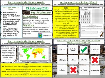
AQA GCSE Geography lesson for the new specification Unit 2A: In this lesson we look at the increasing number of the global population living in urban areas. 
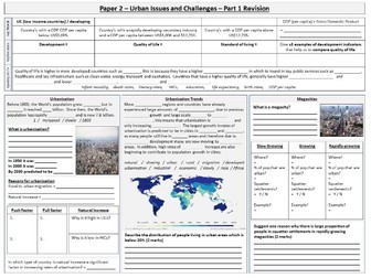
We start with a quick quiz on global populations and a video to put global population increase into context for the pupils. We then look at how urbanisation varies around the world by plotting data on a graph. The pupils then describe the trends they have found. 
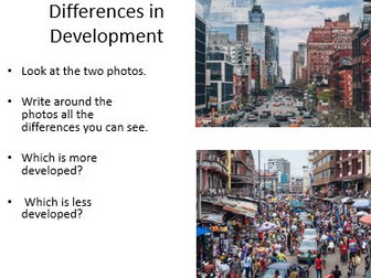
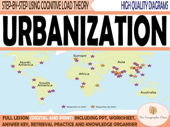
We then look at a map of the urban populations around the world and the pupils can tackle several different questions depending on ability. We then discuss how these patterns might be explained. We then answer a GCSE-style question looking at the percentage of people living in urban areas on different continents using a bar chart. The pupils have guidance on how to answer the question if needed. We finish with a plenary quiz where the pupils have to find the countries with an urban population of over 50%. In a nutshell lesson includes: Quiz starter Video clip Graph plotting exercise with questions Map interpretation task GCSE-style question using graph with guidance Plenary quiz. Hope this saves you some valuable planning time. https://www.tes.com/teaching-resources/shop/markthegeographer
The Development Gap: Measuring DevelopmentQuick View
markthegeographer

The Development Gap: Measuring Development

(0)
AQA GCSE Geography lesson for the new specification unit 2B. In this lesson we look at how development can be measured. There is a short multiple choice retrieval practice starter. We begin by looking at the difference between standard of living and quality of life. After this the students complete an activity matching the descriptions of the development indicators up with the pictures and colour coding them into social and economic indicators. The students then create a paragraph detailing why some indicators may not be reliable, but use the pictures to work out what the missing words might be. We then look at HDI and what is is made up of. The students complete a quick activity on matching the pictures to the benefits of using HDI as a development indicator. A short game of HDI higher or lower follows which is a fun way to spark debate and consolidate learning. We then tackle a 4-mark GCSE-style question with some suggested points to use on the next slide so the students can correct/feedback on their answer. hope this saves you valuable planning time. https://www.tes.com/teaching-resources/shop/markthegeographer
UrbanisationQuick View
TheGeographyOasis

Urbanisation

(0)
Urbanisation Content: A description of the growth of the proportion of people living in urban areas since 1700. A comparison of rates of urbanization between continents and countries at different levels of development. Reasons for urbanization including natural increase and rural-to-urban migration. Geographical skills including line graphs, pie charts, scatter graphs. Each resource includes: Worksheet with activities. Teacher PowerPoint with diagrams and answer key provided directly onto the slides or in notes section of each slide. Activate- a starter, an introduction, a stimulus. Content- The Geographical knowledge- supported by short activities, images, graphs, diagrams. Review- a plenary, recall activity, AFL, knowledge check. Useful links- to video clips, websites etc. Bonus Materials: Knowledge Organiser Interactive assessments (Self-marking Google Form, Keyword Quizlet, Multiple Choice Quizizz) Don’t want to purchase the full resource? CHECK OUT THE ‘MINI’ RESOURCE (Knowledge organiser and AFL activities) What’s included: A word document worksheet that includes activities that introduce key terminology, helps students to describe the growth of urban populations, describe and explain differences between continents and countries, and an explanation of reasons for this growth. The word document is 8 pages. The word document is provided in colour and grayscale. This worksheet is also provided as a PDF. A PowerPoint version of diagrams and answers The PowerPoint is 23 slides Other settlement geography resources: Settlement Patterns, Site and Function Settlement Hierarchies and Services Urban Land Use (Models) Urban Problems and Solutions megapack Urban Problems and Solutions in London Congestion in London Urban decline and regeneration in the East End of London Decentralisation of retail (Out of Town shopping centre) Urban Sprawl in Kuala Lumpur Rapid Urban Growth and Slums in Mumbai SETTLEMENT BUNDLE
The Development Gap: What is the 'Development Gap'?Quick View
markthegeographer

The Development Gap: What is the 'Development Gap'?

(0)
AQA GCSE Geography lesson for the new specification unit 2B. In this lesson we look at what development means and what the development gap is. We also look at the patterns of development globally and the reasons for uneven development. There is an Ordnance Survey-themed retrieval practice starter included. We begin by looking at how development can be measured and comapre HDI with GNI using a table and the students summarise the information and determine which they think is the better measurement. We look at the global patterns of HDI and the students have a map with a variety of questions around the outside for them to answer. Then we examine how countries are classified into LIC’s, NEE’s and HIC’s, the students subsequently try to determine which countries belong in which categories. After completing the definition of the development gap, the students then complete an activity where they consider the factors that affect the level of development of a country. The students categorise these factors into social (historical), environmental, political and economic categories. The next slide has some picture clues and anagrams for the students to work out what the factors are. We then tackle a 6-mark GCSE-style question. There is a writing frame for structure and guidance on points to use. hope this saves you valuable planning time. https://www.tes.com/teaching-resources/shop/markthegeographer
KS3 UrbanisationQuick View
sapnaharia91

KS3 Urbanisation

(0)
FULLY resourced lesson. An observation lesson for urbanisation in the unit of Population. Students look at a made up scenario about the teacher (you can edit the name) and their decision about moving from a rural area to an urban area. This was taught at KS3 and students loved the idea of their teacher being in the lesson. The following ideas are explored: What is urbanisation? Push factors from rural areas Pull factors into urban areas Lots of AFL, reviewing key terms, challenge and literacy.
Sustainable Development and UrbanisationQuick View
SimpleGeography

Sustainable Development and Urbanisation

(0)
This lesson is designed to last for 50-60 minutes and is resourced with videos, extension questioning, deep thinking and uses graphs/images to aid learning. This lesson follows the Oxford KS3 curriculum and looks at the definition of sustainable before looking at sustainable development examples from various countries around the world. Students will be able to identify sustainable factors and unsustainable factors and explain why they are so. This lesson includes a starter, lesson objective, plenary and various student led activities. If you liked this resource please check out my other resources at https://www.tes.com/teaching-resources/shop/SimpleGeography
KS3 Development - Measuring DevelopmentQuick View
markalanwilliams10

KS3 Development - Measuring Development

(0)
A lesson for the topic of Development. Ideal for years 7 to 9. Previously taught in a 1hr lesson. This lesson focuses on looking at ways of measuring development. This this lesson, pupils will look at a variety of measures of social development and attempt to correctly place descriptions into the boxes on the social development worksheet. Pupils will also use their knowledge of HIC's, NEE's and LIC's to attempt to locate 10 countries on a GNI per capita ($) vs Life expectancy sheet. Pupils will also explore the human development index. Spellings homework included.
The Development Gap: Wealth and HealthQuick View
markthegeographer

The Development Gap: Wealth and Health

(0)
AQA GCSE Geography lesson for the new specification unit 2B. In this lesson we look at why there are disparities in wealth and health both within and between countires. There is a rivers themed retrieval practice starter. We then look at the global state of wealth inequality and where the world’s wealth is and isn’t. We then look at how economic development has created inequalities in the USA. The students watch a video and note down the different types of inequality. The students complete a match-up activity identifying some of the main factors that lead to inequalities in wealth. We then look at health, the students complete a diagram using hexagons that shows how development might be linked to health. We then look at what malaria is and the students complete a colouring by numbers exercise to show the global distribution of malaria. They then watch the Disney information film ‘The Winged Scourge’ and answer questions. We then complete a mind map to show how some less developed countries are more at risk from malaria and categorise these into social, economic and environmental reasons. We then tackle a 6-mark GCSE-style question and the pupils use a writing frame and some points suggestions to help answer the question if needed. hope this saves you valuable planning time. https://www.tes.com/teaching-resources/shop/markthegeographer
The Development Gap: MigrationQuick View
markthegeographer

The Development Gap: Migration

(0)
AQA GCSE Geography lesson for the new specification unit 2B. In this lesson we look at how uneven development causes international migration. there is a retrieval practice starter based on development indicators. We start the lesson with a match-up activity where the students match the type of migration to the descriptions. The students then create a diagram that looks at the positives and negatives of international migration for the country and origin and the host country. We then complete a cloze exercise looking at economic migration to the UK. We then introduce the Middle East (Mediterranean) migrant crisis. The students complete a guided reading task then use an atlas to plot the routes of migrants in three example stories on a map of Europe. We then tackle a 4-mark GCSE-style question and the pupils use a writing frame and some points suggestions to help answer the question if needed. hope this saves you valuable planning time. https://www.tes.com/teaching-resources/shop/markthegeographer
The Development Gap: Tourism in JamaicaQuick View
markthegeographer

The Development Gap: Tourism in Jamaica

(2)
AQA GCSE Geography lesson on reducing the development gap in Jamaica. ****You will need the Oxford GCSE Geography textbook for AQA (second edition). This lesson contains a differentiated a3 worksheet for the pupils to workthrough using the textbook. There is a variety of tasks that the pupils can choose from and some video clips on Jamaica to give the pupils a brief insight into the island. Included are:- Starter activity Video Clip A3 Differentiated Worksheet. Hope this helps. https://www.tes.com/teaching-resources/shop/markthegeographer
The Development Gap: Changing Population StructuresQuick View
markthegeographer

The Development Gap: Changing Population Structures

(0)
AQA GCSE Geography lesson for the new specification unit 2B. In this lesson we look at how population pyramids can reveal changing population structures and levels of development. There is a literacy starter based on the content learned so far in the unit. We begin with an introductory video on population pyramids and the students have a question sheet to answer whilst they watch the video. Using the information they have gleaned from the video they then annotate two contrasting population pyramids to consolidate how the graphs can reveal a great deal about a country’s level of development. We briefly look at dependency rations and the students have a go at calculating a simple example ratio. We then construct a population pyramid for Nigeria using a worksheet and the students can then consider what it reveals about the country. The students then examine an ageing population but looking at Japan’s changing population structure and the students complete a task looking at the factors that have contributed top this. We then tackle a 6-mark GCSE-style question using the population pyramids they annotated earlier. There is a writing frame for structure and guidance on points to use. . hope this saves you valuable planning time. https://www.tes.com/teaching-resources/shop/markthegeographer
The Development Gap: Aid and Intermediate TechnologyQuick View
markthegeographer

The Development Gap: Aid and Intermediate Technology

(0)
AQA GCSE Geography lesson for the new specification unit 2B. In this lesson we look at how aid and intermediate technology can help to reduce the development gap. There is a literacy retrieval starter where the students pick three words from the last few lessons to link together in a sentence. We then look at the different types of aid and students need to match the type of aid to the description. They then complete a cloze exercise to explain how aid can help to reduce the development gap. We look at the Goat Aid scheme from Oxfam and the students use a poster template to complete and colour in a Goat Aid poster. We then look at the definition of intermediate technology and the students complete a quiz on whether the examples on the board are intermediate technology or not. We then look at the example of Adis Nifas in Ethiopia and the students annotate a grid of symbols to show the features of the scheme. We then tackle a 6-mark GCSE-style question and the pupils use a writing frame and some point and evidence suggestions to help answer the question if needed. hope this saves you valuable planning time. https://www.tes.com/teaching-resources/shop/markthegeographer
The Development Gap: The Demographic Transition ModelQuick View
markthegeographer

The Development Gap: The Demographic Transition Model

(0)
AQA GCSE Geography lesson for the new specification unit 2B. In this lesson we look at the Demographic Transition Model. There is a multiple choice retrieval practice starter before we look at what the term ‘demographic transition’ means. The students have some sentence fragments to put in order. We then look at some key terminology that is needed for the lesson and the students match the description up to the term. We then look at the model itself an the students have a large A3 sheet to draw the model onto the template. The model is explained in stages and students make notes as they go along, drawing the three lines on too. There is a living graph activity to do when they have finished, by reading the statements in the boxes, they then have to work out which stage it applies to. We then look at examples of countries in the various stages of transition and the students create a diagram titled ‘The Road to Development’. We then tackle a 6-mark GCSE-style question. There is a writing frame for structure and guidance on points to use. hope this saves you valuable planning time. https://www.tes.com/teaching-resources/shop/markthegeographer
AQA GCSE Geography: The Development GapQuick View
markthegeographer

AQA GCSE Geography: The Development Gap

11 Resources
Complete sequence of lessons for Unit 2, Section B (The Development Gap) of the AQA GCSE. Jamaica is the case study for tourism. The lessons included are detailed below. What is the Development Gap? Measuring Development The Demographic Transition Model Changing Population Structures Wealth and Health Migration Foreign Investment and Industrial Development Aid and Intermediate Technology Fair Trade Debt Relief and Microfinance Tourism in Jamaica Hope this saves you some valuable planning time. https://www.tes.com/teaching-resources/shop/markthegeographer
Uneven Development LessonsQuick View
matthew_geldard98

Uneven Development Lessons

(0)
Two full KS3 lessons on uneven development around an hour each. Lessons includes a starter, learning objectives and plenary. Lessons look at both the physical and human causes of uneven development and get students to critically think about how these different factors are able to impact development. All supporting worksheets included - no further resources required.
Challenges of an Urbanising WorldQuick View
TheGeographyShopOriginal

Challenges of an Urbanising World

(0)
Unit 3: Challenges of an Urban World - Complete Unit. L1 - 3.1 : Why is the world becoming increasingly urbanised? (FREE DOWNLOAD) - https://www.tes.com/teaching-resource/urbanisation-world-12484465 This is a GCSE Edexcel B unit, created to a high standard and has been delivered to my GCSE classes over the last two academic years. This SoW work has been differentiated, with with both support and challenge throughout. Retrieval Practice and Duel Coding Theory are incorporated and as well as regular links to other parts of the syllabus, this is in line to my recent academic readings. Geographical and numeracy skill have been planned for. Thanks for looking and any feedback welcome… thegeographyshoporiginal@gmail.com Leave a review for any single resource FREE! Best FREE Resources (The Geography Shop) https://www.tes.com/teaching-resource/-12899088 (Climate Change SoW) https://www.tes.com/teaching-resource/-12899440 (Development SoW) https://www.tes.com/teaching-resource/-12638984 (Waste SoW) https://www.tes.com/teaching-resource/-12451443 (Britain Globalisation SoW) https://www.tes.com/teaching-resource/-12741793 (Local Area Investigation SoW) https://www.tes.com/teaching-resources/bundler/12949461 (Cambridge International) https://www.tes.com/teaching-resource/-12922653 (Israel & Palestine) https://www.tes.com/teaching-resource/resource-12485457 (What is Geography?) I hope you find this SoW useful. If you have, I have created a series of resources, one for each unit of the Edexcel B Geography course, as well as many KS3 units, all to the same standard. You can check them out here… https://www.tes.com/teaching-resources/shop/TheGeographyShopOriginal SoW: L1: Why is the world becoming increasingly urbanised? (Free download) L2: What and where are the world’s mega-cities? L3: Urbanisation is a result of socio-economic processes and change L4: Why Do Urban Areas Vary in their Socio-economic Nature? L5: Cities change over time and this is reflected in changing land use L6: How does Manchester’s land use vary? L7: What is the site and situation of Mumbai? L8: What is the urban structure of Mumbai? L9: How and why has Mumbai’s population changed? L10: What are the challenges within Mumbai? L11: What are the opportunities within Mumbai? L12: What are the inequalities within Mumbai? L13: Exam Practice Mumbai.
Changing pattern of urbanisation - GCSE GeographyQuick View
ssisimms

Changing pattern of urbanisation - GCSE Geography

(0)
This resource was created to address the demands of the first bit of content from Topic 5: Urban Futures of the OCR B (Geography for Enquiring Minds) specification. The lesson helps students with the skill of describing information shown on graphs and charts that is so integral to the GCSE course. The main idea I use to help students is the acronym GCSE - General comment, Specific Data and Exceptions. The lesson focuses on rates of urbanisation in contrasting countries and contains a fun higher / lower activity for the plenary. All resources for the lesson have been provided and it has a nice differentiated summary activity. In the past students have created their own choropleth map using percentage urban data and have then described the patterns shown.
UrbanisationQuick View
chri2834

Urbanisation

(16)
This is designed as the first lesson in the AQA A specification topic 'Change in urban environments'. It introduces urbanisation and its causes.
The Development GapQuick View
WillsonEducation

The Development Gap

(25)
This booklet helps students understand the development gap by completing activities about: Key Words, A World Divided, How We Measure Development, Adult Literacy, How Does The Development Gap Grow?, The Cycle Of Hunger, Fairtrade and Aid