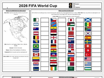
A PPT and A3 double sided word document for students to complete on the 2026 World Cup with a variety of tasks:
Marking on stadium locations.
Identifying flags.
Looking at the advantages and disadvantages of hosting a World Cup.
Comparing country data to decide who should host the 2038 World Cup.
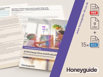
If you’re looking to explore your school’s provision and curriculum in Understanding the World (UW) for your early years children, this audit pack gives you the perfect starting point. Aimed at primary school settings, the audit can be used by both EYFS leads, year 1 leaders & teachers, and curriculum leaders to explore how effectively your school gives children broad and exciting UW learning opportunities and where there are opportunities to develop further. Links are also made between the EYFS and the National Curriculum subjects in Year 1 to provide support for that crucial transition, and is ideal if you’re looking to provide a cohesive curriculum offer.
Further EYFS leadership resources can be found on our website.
Understanding the World audit for Reception and EYFS provisions. Understanding the World audit only.
The comprehensive EYFS deep dive and audit pack can be found on our website Honeyguide SLS for £17.50.
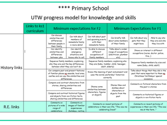
EYFS Reception Understanding the World knowledge progression map from basline to ELG across the terms of the academic year. Prior learning links to Development Matters 3-4 Years made as well as links to future learning within the KS1 National Curriculum.
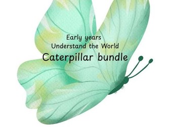
a lovely bundle of resources to support the teaching of caterpillars, focussing on Understanding the world. Included is:
watercolour visual discs with vocabulary for the lifecycle of a butterfly
photographic visual discs and frames with vocabulary for the lifecycle of a butterfly
a watercolour life cycle of a butterfly with a blank one and seperate pictures for the children to order themselves
a cut and stick lifecycle that the children can colour and label
visual discs of different types of butterflies
visual discs of different types of caterpillars
Complete lesson
All resources required for lesson attached, including video links in PowerPoint notes section.
PowerPoint self explanatory.
LOs
Define key population terminology.
Identity sparse and dense populated places.
Explain why population follows a pattern of distribution.
Activity sheet with a large world map in the centre.
Labels for the continents and oceans at the top and bottom, students can cut and stick or link up with lines. They're then asked to find their home country and label it to understand where it is in the world.
Great to photocopy onto A3 to increase the map size.
2026 FIFA World Cup French Project Booklet | KS3 French | World Cup Activities | Cultural Capital
Bring the excitement of the 2026 FIFA World Cup into your French classroom with this engaging and visually appealing 20-page French project booklet, designed to develop vocabulary, reading, writing and intercultural understanding through the theme of football.
Perfect for Years 7–9, transition activities, enrichment days, end-of-term projects or cover lessons, this booklet combines language learning with one of the world’s biggest sporting events. Updated specifically for the 2026 FIFA World Cup hosted by Canada, Mexico and the United States, it provides a motivating context for practising key French skills.
What’s included?
• Introduction to the 2026 FIFA World Cup and participating teams
• Activities based on the 2026 World Cup groups
• French countries and flags matching task
• Reading activity on international football players and national teams
• True or false comprehension tasks
• World Cup history timeline activity (1930–2026)
• Football-themed French vocabulary exercises
• Translation activities using opinion phrases
• French-to-English and English-to-French sentence-building tasks
• Football-themed word search
• Labelling activity on football equipment vocabulary
• Creative football kit design task
• Reading comprehension activities based on famous footballers including Kylian Mbappé, Jude Bellingham, Erling Haaland, Sadio Mané and Harry Kane
• Independent research and writing tasks on students’ favourite football players
• Reflection and celebration pages to conclude the project
Why use this resource?
✓ High levels of student engagement through a real-world sporting event
✓ Supports vocabulary acquisition and cultural awareness
✓ Encourages creativity alongside language development
✓ Suitable for mixed-ability groups with a variety of task types
✓ Ideal for collapsed curriculum days, enrichment weeks, sports-themed learning or independent projects
Curriculum links
This resource supports the development of key skills within the KS3 National Curriculum for Languages, including:
• Reading comprehension
• Translation skills
• Vocabulary development
• Sentence construction and writing
• Cultural understanding and international awareness
Although not written for a specific GCSE specification, the resource also provides useful reinforcement of high-frequency language and thematic vocabulary that can support progression towards AQA GCSE French.
File types included
• PDF (.pdf) – ready to print as an A4 booklet or use digitally via a virtual learning environment.
Whether you’re looking for a French World Cup project, football-themed French activities, a KS3 French booklet, or engaging end-of-term language resources, this booklet offers an exciting way to celebrate the FIFA World Cup 2026 while developing students’ confidence in French.
Resource preview available here:
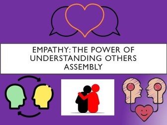
This educational 30 slide assembly focuses on the importance of empathy in secondary school, exploring how to develop empathy skills and its impact within the school community. Students will discover the value of understanding others’ perspectives, fostering positive peer relationships, resolving conflicts with compassion, and cultivating a culture of kindness. Through reflection and actionable tasks, they will be empowered to embrace empathy, creating a supportive and inclusive environment for a successful academic year.
Included in this assembly
What is empathy?
Why is empathy important?
Active Listening
Perspective Talking
Empathy in action
Conflict Resolution
The Ripple Effect
Informative Video’s
Self Reflection
Follow Up Tutor Time Task
Please also visit my TES Assembly Store where over 100 assemblies are available on a huge range of topics.
This pack contains a PowerPoint used in a network training session with loads of ideas for activities linked to Understanding the World. There is wealth of pictures, resource ideas, links to useful websites and some activity sheets.
More resources @ https://www.tes.com/teaching-resources/shop/Whitley01
EYFS Understanding of the World objectives and Early Learning Goals, split by strand and age. Includes 30-50 months and 40-60+ months. Great for display!
This resources provides topic overviews for understanding the world in EYFS.
Curriculum intent and topic coverage for Past and Present / The natural world / people culture and communities.
A clear progression from Nursery into reception and a clear progression from EYFS into Year 1 with direct example.
Evidence of how the curriculum getting children children year 1 ready through linking the ELG to Year 1 national curriculm content.
All content is linked to development Matters.
Important - Developing experts resources are may be required to benfit fully from the natural world curriculum.
This lesson is designed for KS2 students. It can be taught as a stand alone lesson but is also available as part of three wider units, all of which are available on TES:
-Volcanoes
-Earthquakes
-Volcanoes & Earthquakes
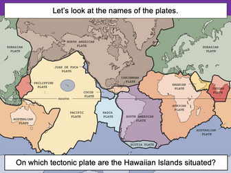
The presentation introduces the idea that the world’s crust is split into tectonic plates and looks at how these are related to volcanoes and earthquakes.
The activity challenges students to identify tectonic plates using a map. It is differentiated two ways:
Easier – Students identify the world’s tectonic plates using a colour-coordinated map.
Harder – Students identify the world’s tectonic plates using a plain map.
Extension – Students use an atlas to find out which tectonic plate countries of the world are located on.
If you like this resource, we would appreciate a review! We will happily send you a free resource in return for a review or useful suggestions/feedback. Contact us at ed@teachitforward.co.uk.
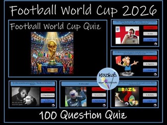
This resource contains a 100-question PowerPoint quiz on the 2026 FIFA Football World Cup tournament. Each question has three possible answers. The answers can be found by clicking on the ball image at the bottom right-hand corner of each slide. An answer sheet is provided to allow individuals/teams to record their answers. The quiz is divided into 6 categories:
Past World Cups
World Cup Records
Miscellaneous
Picture Round
World Cup 2022
World Cup 2026
Sample questions:
How many times have England won the World Cup?
Who has played the most games for England at a World Cup?
Who scored the infamous ‘hand of God’ goal in 1986?
Which is the only country to have taken part in every World Cup tournament?
Which country has won the World Cup the most times?
The PowerPoint contains links to Pele’s 5 top World Cup goals, news report on the stolen world cup in 1966 and Pickles the dog, the World Cup Willie song, the highlights of the 1966 World Cup final, Maradona’s controversial ‘hand of God’ goal against England, highlights of the 2022 World Cup and the 2026 World Cup mascots.
Please note, the watermark on the preview images is not present on the resource itself.
You may also be interested in:
Football World Cup 2026 -115 Slide Presentation
Save money and buy both resources at a discounted rate:
Football World Cup Quiz 2026 - 100 QuestionPowerPoint Quiz and 115 Slide Presentation
Football World Cup 2026 - Fixtures and Results Templates
Thinking of publishing your own resources or already an author and want to improve your resources and sales? Check out this step-by-step guide:
How to Become a Successful TES Author: Step-by-Step Guide
30+ question quiz is played in pairs - 1 partner reads the clue words and the partner has to give the answer.
Alternative remove the answers from each slide and use as a whole class exercise.
This has excellent pictures/images to motivate students and provoke discussion.
I have found these activities work brilliantly!!
Taken from our PSHE EYFS/KS1 Resource file
One lesson with activities to get the children thinking about key questions.
About the unit in general:
The material in this unit contains ideas on how PSHE and Citizenship can be introduced in the early years. Many of the skills and values that fall within this area of the curriculum are taught throughout each day in an Early Years classroom. The qualities they encourage are illustrated on the following page. Three themes: • Fairness • Relationships • Choices have been covered in depth. Many of the qualities that are developed in PSHE and Citizenship are embraced within these particular subjects. They are fundamental to the Early Years curriculum. Timing In this unit most of the activities would take 10-15 minutes. However, some of the ideas presented are not full activities but suggestions of how to incorporate the topic into the everyday classroom
Find the full unit on TES: https://www.tes.com/teaching-resource/eyfs-pshe-understanding-the-world-back-to-school-unit-of-work-6-lessons-unit-12319666
Leave a review
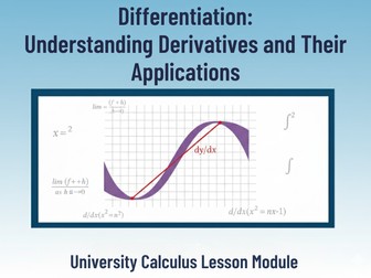
Dive deep into one of the most powerful ideas in mathematics — Differentiation — and help your students master the concept of derivatives as the foundation of Calculus I.
This comprehensive and interactive lesson plan introduces learners to the world of change, motion, and optimization, connecting mathematics to real-world phenomena in physics, economics, and everyday life.
Whether you’re teaching first-year university students or advanced high school learners, this resource is designed to make calculus intuitive, structured, and practical. Students will not only learn how to compute derivatives but also why they matter — understanding the story behind every equation.
**Why This Lesson?
Bridges Theory and Real Life:
Students don’t just memorize formulas — they see how derivatives describe real changes: how fast a car moves, how profits rise or fall, and how nature evolves over time.
Step-by-Step Clarity:
The lesson breaks down every concept with clear explanations, guided examples, and gradual progression, ensuring that learners understand each rule — from the power rule to trigonometric differentiation.
Critical Thinking & Application:
Beyond computation, students tackle optimization problems and rate-of-change applications, gaining the analytical skills they’ll need in physics, engineering, and economics.
Engaging Assessment Structure:
Includes multiple-choice and free-response questions, a guided practice section, and real-world problem-solving tasks to test understanding and boost retention.
Aligned With Academic Standards:
Carefully designed to meet key calculus standards such as HSA-APR.B.3, HSA-APR.C.5, and HSF-IF.B.6, ensuring it fits perfectly into university and advanced secondary curricula.
**What’s Inside This Lesson:
Comprehensive Learning Objective:
Students understand and compute derivatives of polynomial, exponential, and trigonometric functions while exploring their practical uses in optimization and change analysis.
Interactive Opening:
A real-world introduction about speed, motion, and change to connect abstract math to daily experiences.
Detailed Guided Practice:
Includes step-by-step examples (like finding the derivative of 𝑓(𝑥)=𝑥3+2𝑥2−𝑥f(x)=x3+2x2−x) and explanation of common mistakes students make when interpreting derivatives.
Independent Practice & Homework:
A variety of computation and word problems to help students build confidence and fluency.
Assessment Tools:
Ten multiple-choice questions and free-response exercises designed to challenge students’ reasoning and strengthen their problem-solving skills.
Perfect For:
University (Year 1) Calculus I Courses
Advanced 12th Grade Math Classes
STEM programs that integrate mathematics with physics or economics
Tutors & Instructors seeking a ready-to-teach calculus resource
Students preparing for college-level calculus or AP exams
 Quick View