**20+ fully resourced lessons based on Kensuke’s Kingdom - perfect for any Year 6 class. **
Includes a range of extended writing opportunities, exemplar texts (WAGOLLs), reading comprehension questions, differentiated activities, success criteria checklists, collaborative learning tasks and more.
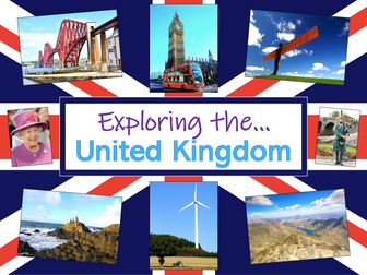
Exploring the UK is a Geography unit suitable for KS1 and lower KS2 (Y2-4).
The planning overview, topic title page and vocabulary page can be downloaded for free here. Lessons include:
L1 – Identifying the countries and capitals of the UK & Ireland (FREE)
L2 – Locating UK cities using compass directions
L3 – Identifying human & physical features of the UK
L4 – Investigating satellite photos of the UK
L5 – Comparing the city and the countryside
L6– Identifying famous features and characteristics of countries of the UK
L7 – Identifying flags of the United Kingdom
L8 – Identifying the four seasons of weather in the UK
Optional lesson – Identifying the countries and capital cities of Europe
Each lesson includes a presentation and differentiated activities/worksheets.
If you like this resource, we would appreciate a review! We will happily send you a free resource in return for a review or useful suggestions/feedback. Contact us at ed@teachitforward.co.uk.
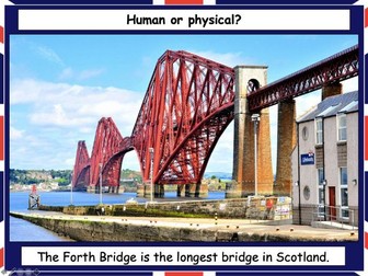
This lesson is part of Exploring the United Kingdom, a Geography unit designed for KS1 and lower KS2 (Y2-4).
The presentation helps students understand the difference between human and physical geographical features. It then challenges them to classify famous UK landmarks as either human or physical.
There are two engaging activities included:
Partner activity:
Students sort pictures/descriptions of UK landmarks into human and physical geographical features.
Individual activity:
Students match pictures of UK landmarks to their descriptions. This is differentiated three ways:
Easier – Students match 8 features to their descriptions.
Medium – Students match 12 features to their descriptions.
Harder – Students write a description of each UK landmark using a word bank.
Extension – Students sort the UK landmarks into human and physical geographical features.
If you like this resource, we would appreciate a review! We will happily send you a free resource in return for a review or useful suggestions/feedback. Contact us at ed@teachitforward.co.uk.
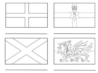
This resource provides an interactive exploration of the United Kingdom’s countries, featuring accurately colored flags for Northern Ireland, England, Scotland, and Wales. It includes a word bank for labeling each country and an extension activity for coloring the Union Jack, enhancing learners’ understanding of the UK’s national symbols and composition.
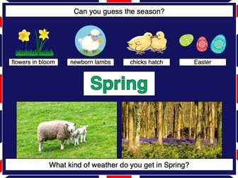
This lesson is part of Exploring the United Kingdom, a Geography unit designed for KS1 and lower KS2 (Y2-4).
In the lesson, students learn about the four seasons and characteristics associated with each. First they have to guess each season using different clues. They then find out about the different types of weather associated with each season.
The colourful activity is differentiated three ways:
Easier – Students match 16 pictures (with labels) to the seasons.
Medium – Students match 20 pictures (with labels) to the seasons.
Harder – Students match 20 pictures to the seasons and label them.
If you like this resource, we would appreciate a review! We will happily send you a free resource in return for a review or useful suggestions/feedback. Contact us at ed@teachitforward.co.uk.
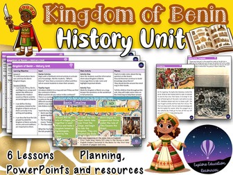
Take your students on an enlightening journey to West Africa with this KS2 history unit focusing on the Kingdom of Benin. Through a series of detailed lessons, students will explore the culture, religion, art, and achievements of the Edo people, and understand the causes and consequences of the kingdom’s destruction by the British. The unit also encourages students to investigate how historians use different sources to learn about Benin’s past and present.
What’s Included:
★ 6 Detailed Lesson Plans: Clear learning objectives, success criteria, and differentiation strategies for each lesson.
★ 6 Interactive PowerPoints: Visually rich presentations that engage students with stunning images and animations.
★ Comprehensive Word Bank: Key vocabulary and definitions to support understanding.
★ Worksheets & Resources: A variety of resources designed to reinforce learning and support assessment.
★ Final Project: Students will write an information text about the Kingdom of Benin, showcasing what they have learned throughout the unit.
Key Skills & Knowledge Covered:
★ Locating Benin on a Map: Understanding Benin’s geographical context and its place in history.
★ Exploring Benin’s Achievements: Describing and explaining the kingdom’s remarkable culture, art, and trade.
★ Comparing Civilisations: Comparing life in Benin with life in Britain during the same period.
★ Impact of Trade: Evaluating how trade and interactions with other cultures influenced Benin.
★ British Invasion: Exploring the causes and effects of the British invasion of Benin.
★ Historical Analysis: Investigating different types of historical sources to understand Benin’s past.
★ Communication Skills: Using appropriate historical terminology to present knowledge and ideas.
This unit is aligned with the National Curriculum for History and is designed for KS2 students (ages 7-11). It can be taught as a standalone topic or integrated into broader studies of African history and culture.
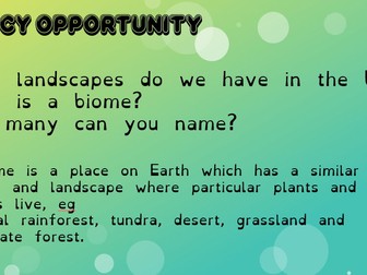
he National Curriculum states that Children should be taught to use basic geographical to refer to key physical features, including beach, cliff, coast, forest, hill, mountain, sea, ocean, river, soil, valley, vegetation, season and weather. Also children should be taught to use world maps, atlases and globes to identify the United Kingdom and its countries, as well as the countries, continents and oceans studied at this key stage. Children should be taught to use simple compass directions (North, South, East or West) and locational and directional language for example: near and far; left and right, to describe the location and features and routes on a map.
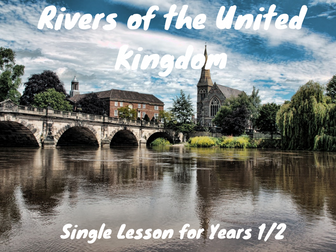
In this lesson children will learn about rivers in the United Kingdom. Firstly, children learn about the course of a river and label a simple diagram. Children will then participate in a quiz about rivers which tests children’s knowledge about the features of the course of a river. Children will then name and locate some of the rivers in the United Kingdom before learning about some of the animals that live in or around a river.
What is included?
*** Complete lesson plan.**
PowerPoint for the lesson.
Labelled course of a river diagram (differentiated on three levels)
Course of a river extension questions for higher-achieving children.
Rivers quiz!
Photographs of rivers in the United Kingdom and fact cards.
Animals that live in rivers: links to YouTube videos.
Animals that live in rivers: fact sheet for class and extension for higher-achieving children.**
Files included:
Rivers of the United Kingdom: Single Lesson for Year 1/2 Lesson Plan in a PDF File.
Rivers of the United Kingdom: Single Lesson for Year 1/2 Lesson PowerPoint.
A practical and visually clear ESL geography worksheet to teach the four cardinal points and map skills using the United Kingdom as context.
Learners identify North, South, East, West and locate cities such as London, Cardiff, and Edinburgh through guided questions.
Includes a complete answer key and easy-to-use layout.
Designed for A1–A2 English learners, this activity links language and geography while promoting communication and spatial understanding.
Printable and editable
Great for pair work or classroom discussion
Suitable for primary or lower secondary ESL lessons
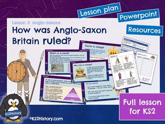
A full lesson for KS2 about how Anglo-Saxon Britain was organised, including a detailed lesson plan, Powerpoint and pupil resource sheets.
How was Anglo-Saxon Britain ruled?
This lesson looks at five major kingdoms from Anglo-Saxon Britain. Pupils will learn about the social hierarchy and will use character cards to rank different people in order of importance. Then they will look at how their local area relates to the kingdom structure and investigate the meaning of local place names that originate from Anglo-Saxon times.
Objectives:
To find out how Anglo-Saxons kingdoms were organised
To investigate Anglo-Saxon place names
The lesson plan includes differentiation ideas to adapt the activities for the needs of your class.
You may also like:
Anglo-Saxons Unit for KS2: A fully-resourced unit of 10 history lessons for KS2, covering the Anglo-Saxon topic.
What was it like in an Anglo-Saxon village? A complete lesson for KS2
Where did the Anglo-Saxons come from? A complete lesson for KS2
This RE SMART and PowerPoint is a series of six lessons based on the UC unit “What kind of King is Jesus?” looking at the concept of the Kingdom of God in Christianity and how Jesus’ teachings are relevant to today’s world. All resources are included and lessons have a mixture of discussion and written activities. Resources include comprehensions and animations of bible passages, a charity pitch activity, a focus on how Jesus is represented in song, a comparison of heaven and Earth activity, a research activity into a Christian charity and a look at forgiveness in practice.
Lessons include videos, group/partner discussion, group tasks, individual tasks and making links to children’s own lives. All resources are included, and there is a printing requirement list for the whole unit. Please note - the SMART and PowerPoint contain the same content, but you need Notebook software to open SMART.
A scheme of work for Michael Morpurgo’s ‘Kensuke’s Kingdom’. It follows the Middle Years Programme framework but should work across multiple curriculums for Key Stage 3. This particular unit was created for a Year 7 class. It includes slides and a Point Evidence Explain Assessment.
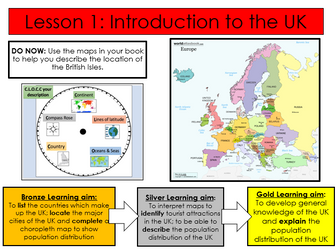
First lesson in a SOW on the geography of the UK.
Fully differentiated with extension activities.
Includes-
Workbook to complete tasks in
Activity identifying the differences between the UK, GB and British Isles
Activity locating major cities in the UK
Extension activities
Choropleth actvity mapping population density of different regions of the UK
Extension activities
Complete lesson
All resources required for lesson attached, including video links in PowerPoint notes section.
PowerPoint self explanatory.
LOs
Define key terminology.
Create a map of the UK.
Describe key facts of the UK.
This is actually intended as Lesson One of an Around the World unit for my year 1 Geography, but it would work well as a stand-alone introduction to the British Isles. It provides a simple introduction to the United Kingdom, with facts about England, Northern Ireland, Scotland and Wales, as well as a mini-assessment at the end with true/false statements the children can answer, based on the learning they have just done.
This booklet helps students to understand where we are located within the UK and what factors influence this. Locations with significant increasing and declining populations are explored with a look into immigration and the medias influence on our views of this
This is a Geography unit of work on the United Kingdom and is a series of 9 lessons focusing on topics of map work, landscape, cities, energy, carbon footprint, transport, tourism, urban v rural and climate change in the UK.
I made this after struggling to find a similar activity! Allows children to discover the names of the different countries and the capitals of the UK.
Give children an atlas and see if they can find them before revealing whether they are right or wrong.
Worked like a treat and built up some great atlas skills!!
This lesson is part of Exploring the United Kingdom, a Geography unit designed for KS1 and lower KS2 (Y2-4).
The presentation first introduces students to satellite photos before going on to challenge them to match satellite photos to famous UK landmarks (e.g. Wembley Stadium, Edinburgh Castle).
In the activity, students use their geography detective skills to describe satellite photos and infer which famous UK landmark or feature each one is. It is differentiated two ways:
Easier – Students write description of each satellite photo on a writing template sheet.
Harder – Students stick satellite photos into their exercise book and write descriptions next to them.
If you like this resource, we would appreciate a review! We will happily send you a free resource in return for a review or useful suggestions/feedback. Contact us at ed@teachitforward.co.uk.
 Quick View