This is designed as an introductory unit on HOT and COLD locations. Photographs are given so that students can separate the hot from the cold locations. Answers are given within the Power Point.
This is a more challenging activity than the one on Hot and Cold Locations (Key Stage 1). Photos are provided in a Power Point. Students are required to analyse the photos and decide whether they were taken in HOT or COLD locations. They are then required to place them on a world map. Clue sentences are supplied to assist their decisions. The chart and the world map are provided as attachments so students can have access to a hard copy. Answers are provided on the final 2 pages of the Power Point.
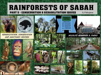
This units takes students to the rainforests of Sabah (Malaysian Borneo). Using map series, photographs and explanation the loss of habitat is revealed. The plight of the orangutan and sun bears whose natural habitat is the rainforest is indicated. Students will be able to recognise the rate of habitat loss and its impact on animal numbers. Rehabilitation programmes are included in the unit. Several pages are duplicated in the 3-page black and white attachment. This unit is designed for upper primary to lower/mid secondary levels. Discussion questions for debate via the screen are given. The orangutan and sun bears are appealing animals. What is happening to them is not appealing.
Students are encourage to sort the words, look at the spelling of the root word, find the meanings of the words if they do not know them and find other words with the same suffix to add to each group. Designed to accompany Jolly Grammar 4 Lessons 24, 26, 27 but will suit other spelling programs.
This exercise encourages students to look at the spelling rules involved in the change like dropping e to add er or doubling after a short vowel+ consonant. They also need to think which part of speech the word is changed to.
In a world where populations pressures place strains on ecological systems the added strain of desertification adds an additional problem. The SAHEL of Africa is an area between the northern desert (Sahara) and the wetter climate zones of the savanna lands. It spans twelve African countries. Most of these have high levels of population pressure and growth. Through the use of maps, diagrams, photographs and selected situations this unit explains why the SAHEL is the major region where desertification is occurring. The unit explores the causes (natural and human) and recognises the consequences. Many of the pages are designed so that teachers can screen them and discuss them in class. The attachment pages are provided so that teachers can have flexibility in how they are used i.e., within the classroom or as individual home study activities. The story of the headman in the abandoned village of Northern Nigeria is provided so that students can gain some idea of the personal impact those affected by desertification experience. The pages providing posters (Oxfam and Unicef) indicate the emergency situationS faced by countries within the SAHEL. The aid programmes are created to assist in the short term. Coping with desertification in the longer term requires more complex and detailed planning.
The remote Galapagos Islands lie almost one thousand kilometres off the west coast of South America. Over thousands of years the thirteen main islands have emerged from the sea. They are volcanic in origin and this unit has a focus on their formation and change. Take your students to the Galapagos and find out what is unique about their formation. Use the attachments and fill-in worksheet to develop understanding. Follow up titles will cover the unique wildlife and the Charles Darwin connection.
Students revise the meaning of synonym and antonym. They also look at the fact that although words have similar meaning, there are also degrees of meaning which can add further clarity to speech and writing. They find an antonym and synonyms for given words and also make choices to improve a story using antonyms.
Students are encouraged to look at the meaning of the prefix and also that of the root word. They look at the meaning and work back to the word, then the word + prefix and work back to the root word. The lesson is designed for Jolly Grammar 4 Lesson 34 but is also useful for many spelling programs.
The warning of a volcanic eruption on White Island New Zealand had been upgraded to Level 2. This had happened before but the level did not stop tours to the island - a major tourist attraction for those seeking a close up encounter with the natural environment. This time the warning was converted to action. The volcanic island erupted in an outpouring of steam, gas and hots small rocks which descended on those nearing the hot water in the crater lake. Follow this unit to see what happened. Find out why White Island is correctly known as “New Zealand’s most active volcano”. Find out what happened to those unfortunate enough to be in the group walking on the island. Use the graphics and photographs to gain an understanding of what happens. The attachments provide activities and an opportunity to gather ideas about likely reactions to the tragedy that figures in New Zealand’s volcanic history and gained world wide attention.
This unit is designed as an introduction to desert environments using a world distribution map and a photograph file. It can be linked with other units on deserts (nomads/oasis/water importance/rainshadow analysis). Answer pages are provided on pages 3 and 4.
This unit begins with a photograph overlooking the ruins of Persepolis in 1971 - the year of the 2500th celebrations of the founding of the Persian Empire. With a focus on the history exposed as the ruins were excavated it follows via a map series the expansion of the Persian Empire under several notable Persian Kings. This unit can stand alone as an examination of this Royal capital. It can also be integrated with the history of the Persian Wars; an examination of the rise and fall of Empire and a lead into the role of Alexander the Great in overthrowing the Persian Empire. The unit poses several questions and provides check questions in the final page. Much of the history lay buried under the ashes of the 330 B.C. fire and the subsequent abandonment and sand covering of the ruins. However the history was recorded in bas-reliefs of the ruins and re-discovered by sifting through the ruins and analysing the written cuneiform records that were preserved in vaults beneath the surface ruins. It's an interesting encounter with ancient history.
The Kokoda Track is a tourist challenging tourist attraction today. Passing through the Owen Stanley Ranges this Track was chosen by Japanese military commanders as the route for their proposed attack and planned control of Port Moresby. Projects and discuss the information provided an maps, diagrams and text to discover why the Kokoda Track became the locations of battles between Japanese troops and the Allied forces of Australia/United States. Become aware of the inhospitable environment endured by combat troops. Find out why, on the point of attacking Port Moresby the Japanese forces were ordered to withdraw. Use the selection of attachments to provide colour or black and white copies for students. Take part in the research worksheet providing a guideline for reasons for the Japanese withdrawal. If you want more visual material you can use the second unit entitled “Walking along the Kokoda Track in 2006”.
Geography students need to know about maps. They need to know how to present maps so that the information is easy to read. Most maps are two dimensional. Landscapes however are three dimensional. This is an introductory approach to developing a contour pattern on a map by using the guidance of spot heights. By completing this activity students will gain an understanding of contour lines and how they indicate different levels of elevation above sea level. The contour lines are then used as a background guide to add some land use areas. The aim of this activity is to produce maps that provide information that is easy to read. The black and white attachment is provided if hard copies of the map completion activity is needed. The extension activity on the last 3 pages leads from the map into aspects of land formations (cliff/erosion; beach deposition) This is more advanced but there may be some students looking for more difficult concepts. Teachers will know the capabilities of their students and select activities to match them.
A range of landforms are shown by photographs and located on a map. The activity requires students to match the photograph numbers to the type of landform. Some landforms have two names - one Aboriginal name and one western name. This opens up the issues of land rights, ownership and the need for conservation and management. This title can standalone or it can be used as an introduction to "Australian Landforms" Parts 1,2,3 & 4 in which the formation processes and evolution are shown in more detail.
This location creates and promotes student interest. Machu Picchu is a unique place with a unique history. This standalone unit cuts across curriculum disciplines of environment, location, geography and history. It can extend knowledge of South America. The addition of fill-in worksheets in colour and/or black and white give you the opportunity to use this material in flexible ways. It can be used as a screen presentation promoting observation and in class discussion. It can be used as a combination screen and individual student activity using the three black and white or colour fill-in handout pages. In terms of curriculum this unit will expand global locational knowledge. It is part of a series that will explore locations with World Heritage listing - some well known and some less known. Students having an interest in discoveries and scientific archaeology will find this location appealing. Machu Picchu is a significant World Heritage site. It is also included on many lists as one of the Seven Wonders of the Modern World. Take your students into the thin air of the Andes and visit these Inca ruins. Be prepared to be impressed.
Through description, photographs and diagrams the formation of Uluru is explained. The role of structure, processes leading to change and formation are shown. The issue of traditional ownership is mentioned. The issues of ownership and management could lead out from this study of the landform. Further landform studies are covered in "Australian landforms" Part 2, 3 & 4 This activity could also be an introduction to Year 10 ACHGK071
Questions about survival, decision making. Environment. The choices we make and reasons for those choices. All based around Shackleton's famous Antarctic Expedition and the miraculous survival of Shackleton and his crew.
 Quick View
 Quick View
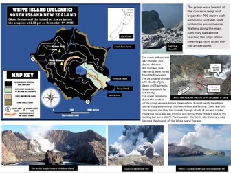 Quick View
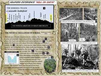 Quick View