
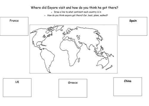
Worksheet with several countries listed, the task is to draw arrows from each country as to what continent they are on, atlases can be very useful and help develop map reading/ atlas skills. Extension to the task is to work out whether if you were visiting the country if you were to drive/take a plane/ or a boat there, getting the children to think about travel, would you drive to Australia for example? This worksheet can be used as a base and edited as to how you like. I used this after the easter holidays are the countries listed were places the class teddies had visited over the holidays.
Something went wrong, please try again later.
Brilliant, thank you! Lots to keep little ones happy and busy during lockdown!
Report this resourceto let us know if it violates our terms and conditions.
Our customer service team will review your report and will be in touch.
£0.00