
This resource has been developed to compliment ‘Beyond the View – Canaletto’ - a landmark exhibition taking place at Tatton Park in 2026.
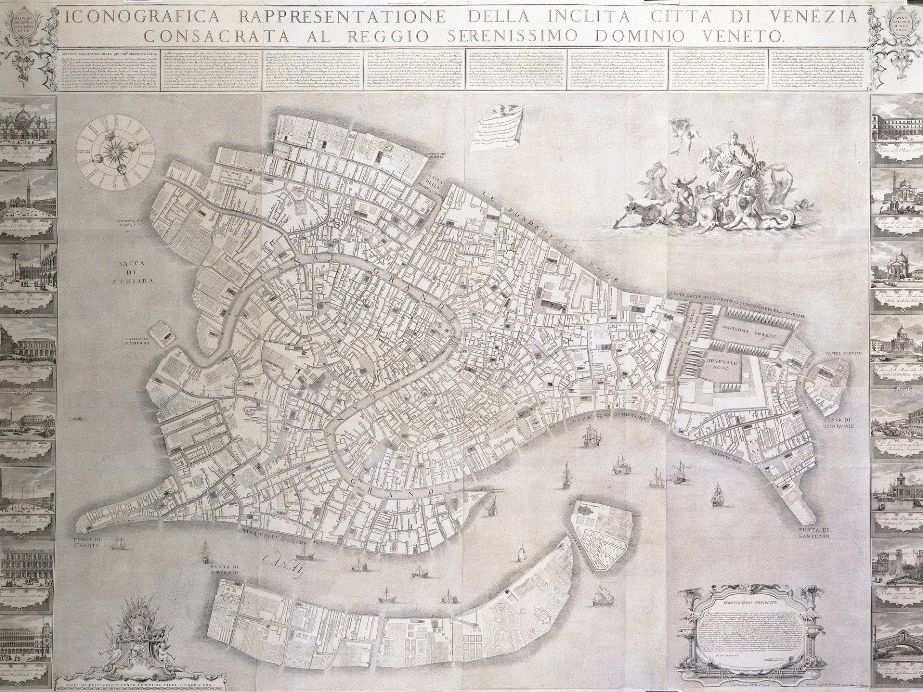
The information and suggested activities bring to life the ‘Ughi Map’ created by Ludovico Ughi in 1729. This incredibly important map of the city of Venice was at the very forefront of surveying and map making techniques. It was such an accurate representation of Venice that it was made use of well into the 19th Century. It is printed on twelve plates, surrounded by 16 prints of key venetian buildings. The map was designed to be cut out of its folio and pieced together, making it 5ft by 6ft in size. The Tatton copy is extremely rare, surviving uncut and in its original folio.
For the exhibition, the Ughi Map will be available to view in its original folio and as a digitally assembled, complete map with all its impressive detail. It is presented along with an engaging interactive story map, which invites visitors to explore the map, draw comparisons with the modern city and connect with the past in entirely new ways.
In this resource, you have access to a bespoke built version of the GIS app through which the Ughi Map is presented for this exhibition. We have also provided a selection of topic specific suggested activities for your consideration.
This project is delivered with the support of Esri UK and our funders, Arts Council England and the Tatton Park Charitable Trust.
Something went wrong, please try again later.
This resource hasn't been reviewed yet
To ensure quality for our reviews, only customers who have downloaded this resource can review it
Report this resourceto let us know if it violates our terms and conditions.
Our customer service team will review your report and will be in touch.
£0.00