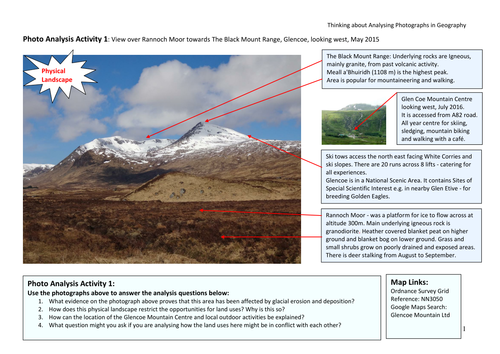


Photographs are readily used in geographical enquiries by 16+ learners, but not always effectively. The presentation shows how to ensure that the photographs used add value to their report or findings. It demonstrates how asking thinking questions of a photograph can improve the quality of annotations and can lead to more in depth analysis. The 6 Photo Analysis Activities provide practice for the learner in answering and creating analysis questions, using photographs of physical, rural upland and urban landscapes. All photographs have a map link and annotated notes.
Something went wrong, please try again later.
Great resource, thank you!
Report this resourceto let us know if it violates our terms and conditions.
Our customer service team will review your report and will be in touch.
£0.00