Spelling test
Introduction (maps)
Adjectives about it
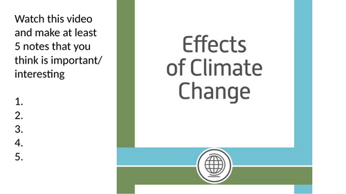
Video
Adjectives now
Discussion about perception - address all the misconceptions
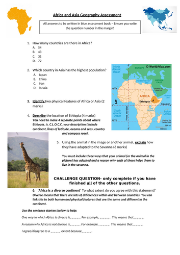
Describe location (gapfill) and challenges
Images and guessing if it’s in the area or not - discussion and address misconceptions again after
Video
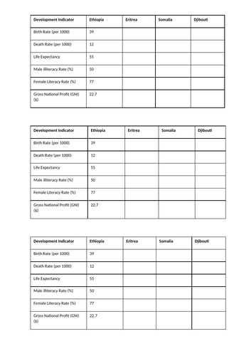
Development indicators
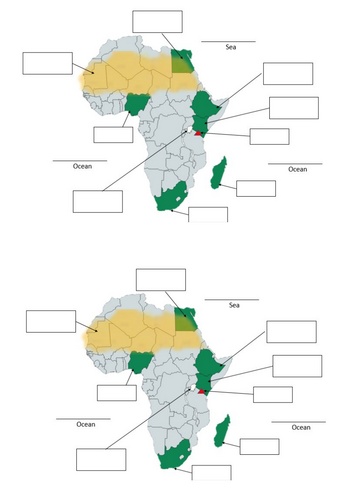
Atlas use - engaging and exploring for students (assist if needed e.g. page number after a while)
Fill in the table (challenges included)
Time limit and show answers - address misconceptions
Compare it to UK. Example on board (gapfill). Lower ability can use board example with gapfill. Higher ability can make their own.
Plenary, which statement is a lie. AFL fingers.
Learning outcomes:
Define the term NEE and give examples.
Rank and justify the improvements you would make to an LIC.
Investigate an African NEE country.
Each time you do one, you refer back to it via AFL with students
Strong focus on command words as these will be in exam questions (for young or older students to be aware of the meaning of these)
Scenario based thinking on own.
Pair work on same scenario but having to agree on one decision together.
Feedback to class
Learning Social/ Economic/ Environmental/ Political. Questions/ prompts per section to help students answer or categorise properly. Do an example together. Model it (especially if they are younger or have needs, otherwise it is already displayed on board)
Students read information and put them into the correct categories (10 minutes). AFL and check whole room progress. I added additional 3 minutes with their goal to have one thing per box as 2-3 boxes were mainly done. Challenge included if needed.
Random sharing. Depending on your student you can allow them to share any box, or you choose a box (but lower ability/ SEND may not have the box you want).
Plenary for students to recheck the intentions and discuss if they met them. This shows their progress and understanding.
Handouts available. SEEP in colour or black and white. Information sheet in colour, and shared handouts to have them exposed to graphs, tables and maps, and to help their partner as the task may be difficult for some.
Assessment
Challenges included
Peer assessing
Show progress before and after.
4 marker question (to assist with end of unit assessment)
When finished, students to keep their books nice and presented etc.
Video
List 10 facts
Plenary discussion
Later:
Teacher mark and award marks, checks through books (every few weeks) - rewards for consistent effort, presentation etc, recognition of students within books, and in class next lesson.
e.g. postcards home for good work and special stamps, okay work stickers, improvements needed nothing (all is based on student’s progress on their ability)
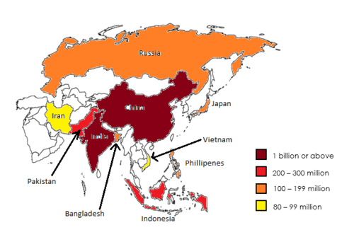
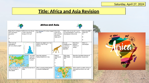
Starter: List as many countries in Asia as you can (prior knowledge)
Peer assess, add 5 to list allows them to learn more within cognitive load
Learning intentions (referred to throughout lesson)
Colour coded map and compass. Think/ Pair/ Share
Students act as the teachers and point out the regions.
Gapfill
What do you need to pack on holiday travelling in Asia?
Video
Image prompts to allow time (EAL, lower ability, SEND). Challenge included for others.
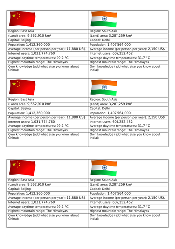
Similarities and differences between China and India (handouts)
Highlight information
Add own facts
2 paragraphs writing (sentence starters)
Answers on board
Bingo key words plenary but teacher uses definitions so students need to think
Fun dingbats game. Example together first.
Learning objectives
Key terms (challenge included)
Explanation - sparse/dense
AFL thumbs
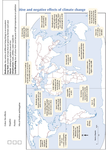
Lots of images - address misconceptions
Information on Asia (China) - Whats the differences discussion
Mind map - example together on board first. (challenge included)
Choropleth map introduction
Create your own (challenge included) - use Atlas
After a while - have countries on board to assist lower ability/ SEND and get them on pace
Answers on board - self check
Describe the distribution - copy example. Students write their own (help lower ability if needed). Challenge included. Having the example already in books allows them to have something available to refer to.
Plenary.
Animals in the Savanna - Lion King Remake of animals - Students well engaged and excited
Learning objectives - command words - meanings
Map of Savanna (students to add to their maps from previous lesson - Physical Geography of Africa). If you don’t have this, the maps (6 to a page) are also included if you wish to make this into an activity to shade in the biome and label the latitudes.
Video about the Savanna - Notes about the biome
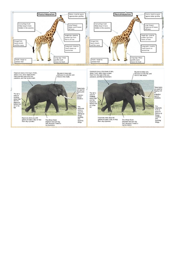
Animal adaptation - I do (Lion), We do (Elephant), You do (Giraffe and Warthog). Challenges included.
All students are able to complete giraffe, lower ability may struggle with warthog so I had them think more about the giraffe. Remind them of Pumba from Lion King.
Answers on board - Students to add 3 more to their animals. Handouts available for students who can’t read, lower ability/ SEND to assist them. My students did not stick them in, they used it as help.
YOU ARE A GEOGRAPHER (Science advanced and you create your own animal!)
Choose 3 characteristics (timer them). Explain why those three and how they adapt to the Savanna.
Criteria and levels (on the board I have 5 and 6). On paper (handouts or printouts or you can adapt depending on your class/ student) I have level 3-7 success criteria.
Key words on the board, connectives on the board, challenges on the board, examples (sentences and images) on the board.
Sentence builders (shared between students) allows every student able to complete the task. Higher abilities will not use it but have it as a reference.
Students will be working at different paces due to ability. My higher ability asked to do more characteristics but only because they completed it. My lower ability/ SEND I expected at least 3 sentences (this is because this is in their assessment so they need to have this). Students who finished are able to sketch their animal. Higher rewards given as motivation.
Peer assessing. Students peer assess the presenter (visualiser if you have). We used fingers due to time, but if you have longer lessons or extend another class they can use the peer assessment handouts where students assess themselves, and then peer assess. They can then improve upon feedback.
Many students loved the task, wanted to share and spend their 15 minutes break continuing.
Full terminology
Starter: key term with word bank
Map reading skills
Describe locations
Examples I do, we do, you do
Peer assessment
Hinge questions AFL
Biome information to read - optional methods/ tasks/ printouts if wanted
Map included for biome annotations
Journey through Russia Map (A, B, C, D)
Describe the biomes, what you see, etc throughout your journey
Success Criterion
Example (I do)
We do - together example
Answers for peer assessment
Plenary
Challenges included: these may be considered “hard” for KS3 but you can teach it or adapt them.
Engaged, fun task. You may need to finish earlier as students tend to not want to finish/ rush and continue/ willing to work into their breaks (but I don’t want them with me at break).
Rivers, Mountains, Deserts, Plains etc.
Prior knowledge check
Video - add to knowledge
Map creation - colour coded and Atlas use
2 versions - 1. blank (students had to really look and discover/ engage with the Atlas), they will ask for help or you can give prompts for harder ones. 2. Marked map (labelled)
Note: I only gave easier maps to students who go to special centres but my low ability and SEND students still did the blank map (they don’t complete it but they learn how to search and use the Atlas well). I did this because it is not in their assessment to know every part and map skills is more valuable for them.
Answers on board for marking
Reading information
Plenary
Extra version of map with key provided for lower ability/ SEND if you wish to use.
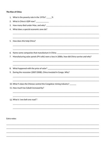
The history of China to now
Can easily be 2 lessons worth
Students are extremely engaged, lots of discussion points. I answered a few and had to tell them to write it down or address it next lesson.
Several tasks to do
Main task
Video with worksheet
You may need to pause depending on your students, or call out each number as you reach it.
Drawing a Then and Now image of China
1-2 hour lesson
Lesson plan attached in full (updated)
Thinking starter image
Facts (prior knowledge check AFL)
Videos with questions on causes and impacts
News report with example, gapfill/ sentence starters
Plenary AFL
Worksheets to print
2 versions (diff AFL)
Updated: Loved lesson by schools. Focuses on literacy. I included emotions helpsheet in this for SEMH students.
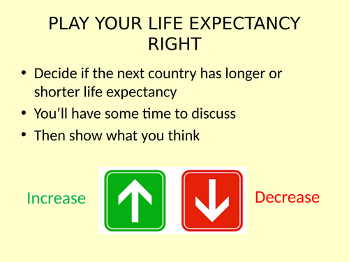
Starter: Life expectancy game using 2024 statistics
Graph - students interpret or you explain
Definition
UK discussion topic - if you have more time - add in a maths question using the numbers (to include numeracy skills in your list)
Graph with lots of prompt questions. Depending on ability and past topics you can decide whether you go through this part together or in pairs/ alone.
Next slides - if they are quite low ability, do address how it links for understanding. Otherwise, it is easily understandable but check in with lower abilities by having them answer/ share (privately or in class depending how supportive the class is and if you manage behaviour well).
Articles, videos included - depending on time and ability you can choose whether to include all. I usually do the summarised slide and a video for lower ability to understand it.
Please address misconceptions that NOT every eldery does this.
Instructions with success criterion
Example which helps a lot
Template provided (print out versions available if you have students who aren’t able to write)
Challenge included
Peer assess - more positives than negatives.
Notes:
I mentioned TA but she just chills at the back of the room most of the time.
High ability (above top set) - if needed - I added lots of information about other countries with videos and personal knowledge (not included in PPT) but I found any of this difficult to fit and engage with average ability as they are only familiar with UK and still lack knowledge on that so I skipped them.
1hr lesson - TEEP model
Images - odd one out and why. Challenge included.
Definitions
Biomes
Animals - information collecting. Challenge included.
Short story on your daily life (as one of the animals)
Sharing
3, 2, 1 plenary
Included full lesson plan
Starter
Atlas use
Maps to label
Mind maps about countries - using stats
Challenges included
Quiz-Quiz-Trade game
Note down some facts from the game
1hr lesson
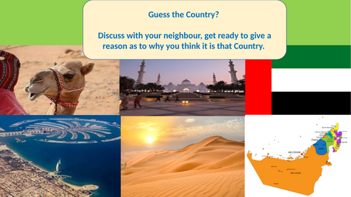
Guess the country images and flag
Describe the location - Atlas use and map
Video - fact information
A3 poster in pairs promoting tourism in airports
Success criteria included - slogans, pictures, facts
Images/ Montage of ideas
Peer assess (group swaps)
Plenary
Identity
Key words
Google Earth - or consider Atlas - depending on students’ locational knowledge and skills
Video with a few comprehension questions - AFL
Images, Atlas, Split, Latitude images/ information available - explanation available if needed.
South Sudan - questions about placement etc. (in lesson plan)
Timeline reading
Mind map ideas - from timeline prompts - you may want to explain, draw etc.
I used Iraq as an example (about the war and religion) - and linking it to humanities - affecting this independence and conflict etc.
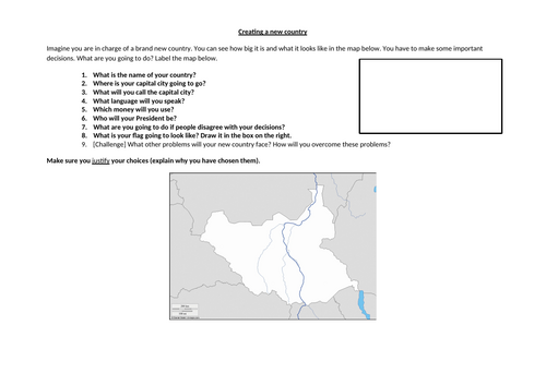
Design your own country - questions to ask to check understanding
Include prompt questions in instructions – e.g., do you want the capital city to be in the mountains or near the river? Why?/ do you want them to speak the same language or something different and why?
Questions about their new country - students to justify
They label their country
Challenges included
Random sharing - wheel of fortune included in PPT. Adjust names.