I've worked in primary teaching for over 10 years and specialise in creating fun and engaging educational resources, particularly for Geography and History.
I've worked in primary teaching for over 10 years and specialise in creating fun and engaging educational resources, particularly for Geography and History.
This is the free planning overview for Tropical Rainforests, a comprehensive Geography unit about tropical rainforests, the most biodiverse terrestrial ecosystems on Earth. A topic title page and knowledge organiser are also included.
The unit is is designed for students in KS2 (Y3-Y6) and includes a variety of engaging lessons, differentiated activities and worksheets. All resources are compatible with both Microsoft Office and Google Workspace.
All the resources described in this unit plan are available on TES, either as individual lessons or as a bundle. Lessons include:
L1 – Locating tropical rainforests on a world map
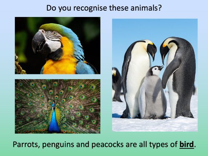
L2 – Identifying tropical rainforest animals
L3 – Investigating the layers of a tropical rainforest
L4 – Exploring the Amazon rainforest
L5 – Understanding the impact of deforestation on the Amazon
L6 – Investigating how deforestation affects an Amazon tribe
L7 - Thinking of ways to help save tropical rainforests
If you like this resource, we would appreciate a review! We will happily send you a free resource in return for a review or useful suggestions/feedback. Contact us at ed@teachitforward.co.uk.
This is the free planning overview for London Zoo, a fun introduction to one of the world’s most famous zoos. A topic title page is also included.
This cross-curricula unit is designed for KS1 and lower KS2 students (Y2-4) and includes fully-planned lessons complete with differentiated activities and worksheets.
All the resources described in this unit plan are available on TES, either as individual lessons or as a bundle. Lessons include:
L1 – Writing a fact file about London Zoo
L2 – Taking a tour of London Zoo
L3 – Using compass directions at London Zoo
L4 – Using grid references at London Zoo
L5 – Matching animals to their habitat
L6 – The history of London Zoo
If you like this resource, we would appreciate a review! We will happily send you a free resource in return for a review or useful suggestions/feedback. Contact us at ed@teachitforward.co.uk.
This is a simple matching activity to help children recognise and identify the continents of the world. It is suitable for children in KS1 & KS2.
This resource works well with the World map jigsaw and Continents and oceans of the world.
It can also be used to play Pelmanism, a fun game which promotes concentration and memory skills.
If you like this resource, we would appreciate a review! We will happily send you a free resource in return for a review or useful suggestions/feedback. Contact us at ed@teachitforward.co.uk.
This is the free planning overview for Great Missenden – A Village Settlement. A topic title page is also included.
Located in the Chilterns in Buckinghamshire, the village of Great Missenden was once home to famous children’s author Roald Dahl. It is a great case study for helping students understand the similarities and differences between urban and rural settlements.
The unit is designed for students in KS2 from Y4 to Y6 and includes a variety of engaging lessons, differentiated activities and worksheets.
All the resources described in the planning are available on TES, either as individual lessons or as a bundle. Lessons include:
L1 – Locating Great Missenden in the UK
L2 – Investigating satellite photos of Great Missenden
L3 – Locating features of Great Missenden using grid references
L4 – Identifying the features of settlements
L5 – Surveying Great Missenden High Street using Google Street View
L6 – Interpreting a high street survey of Great Missenden
If you like this resource, we would appreciate a review! We will happily send you a free resource in return for a review or useful suggestions/feedback. Contact us at ed@teachitforward.co.uk.
This simple set of activities is a great way for students to sharpen their map skills and learn the location of the states of the USA.
The worksheets can be used as an introduction to the geography of the US for younger students or to revise core geographical knowledge with older students. The states are even numbered in the order in which they joined the Union! There are three activities:
Activity 1:
Students write numbers on a map to identify each US state.
Activity 2:
Students use an atlas or map and write in the full name of each US state.
Activity 3:
Students use state abbreviations to write in the full name of each US state.
For more Geography and History resources, check out our TES shop.
If you like this resource, please review it. We will happily send you a free resource of your choice in return for a review or useful suggestions/feedback. Contact us at ed@teachitforward.co.uk
This resource is part of Exploring Australia, a Geography unit designed for students in upper KS1 and lower KS2 (Y2-Y4). All resources are compatible with both Microsoft Office and Google Workspace.
The display pack comes in A4 and A2 sizes and contains the following:
-Exploring Australia title banner
-A map of Australia
-The Australian flag
-14 famous Australian landmarks
-10 famous Australian animals
If you like this resource, we would appreciate a review! We will happily send you a free resource in return for a review or useful suggestions/feedback. Contact us at ed@teachitforward.co.uk.
This resource is part of Exploring Australia, a Geography unit designed for students in upper KS1 and lower KS2 (Y2-Y4). All resources are compatible with both Microsoft Office and Google Workspace.
First the presentation compares and contrasts the UK and Australia, specifically focusing on:
-Location in the world
-Size/population
-Languages spoken
-Climate
-Native animals
-Famous landmarks
The activity then challenges students fill in a table comparing the UK and Australia.
Easier - Students fill in information for 7 categories (with vocab hints).
Harder - Students fill in information for 9 categories (no vocab hints).
Extension - Students identify whether animals are native to the UK or Australia.
If you like this resource, we would appreciate a review! We will happily send you a free resource in return for a review or useful suggestions/feedback. Contact us at ed@teachitforward.co.uk.
This resource is part of Exploring Australia, a Geography unit designed for students in upper KS1 and lower KS2 (Y2-Y4). All resources are compatible with both Microsoft Office and Google Workspace.
First the presentation recaps Australia’s location in the world. It then introduces Australia’s eight main states/territories and their capital cities.
The activity then challenges students to locate and identify Australia’s states/territories and major cities.
Easier - Students identify 8 cities and states/territories (first letter clues).
Harder - Students identify 10 cities and states/territories (no clues).
Extension - Students identify more Australian cities on their map.
If you like this resource, we would appreciate a review! We will happily send you a free resource in return for a review or useful suggestions/feedback. Contact us at ed@teachitforward.co.uk.
This resource is part of Exploring Australia, a Geography unit designed for students in upper KS1 and lower KS2 (Y2-Y4). All resources are compatible with both Microsoft Office and Google Workspace.
First the presentation introduces the concepts of human and physical before looking at some of Australia’s famous landmarks, from the Sydney Opera House to the Great Barrier Reef.
The activity challenges students to look at ten famous geographical features of Australia and identify them as human or physical:
Easier - Students look at each feature and circle human or physical.
Medium - Students draw each feature and circle human or physical.
Harder - Students identify each feature and label as human or physical.
Extension - Students complete a cloze-procedure paragraph about Australia.
If you like this resource, we would appreciate a review! We will happily send you a free resource in return for a review or useful suggestions/feedback. Contact us at ed@teachitforward.co.uk.
This resource is part of Tropical Rainforests, a Geography unit designed for students in KS2, but can also be taught as a stand alone lesson. All resources are compatible with both Microsoft Office and Google Workspace.
The presentation starts by recapping the issue of deforestation and its detrimental impact on rainforests around the world. It then challenges students to think of practical ways we can all help protect tropical rainforests (e.g. buying sustainable products, using less paper).
Next, it introduces some of the charities working to save the world’s tropical rainforests including the Rainforest Trust and WWF. If your students wish to organise a fundraising event, there are lots of ideas and inspiration.
For their activity, students create a ‘Save the Rainforests’ poster to advertise your fundraising event and/or raise awareness of ways we can all help protect tropical rainforests.
If you like this resource, we would appreciate a review! We will happily send you a free resource in return for a review or useful suggestions/feedback. Contact us at ed@teachitforward.co.uk.
This lesson is part of a wider cross-curricula unit called London Zoo which is designed for KS1 and lower KS2 students (Y2-4).
The animals have escaped at the zoo and the keeper needs your help! The presentation first encourages students to describe the features of animals. It then challenges students to match animals to their names, description and habitat. It includes a variety of animals including fish, birds, mammals, insects and amphibians.
There is a group activity and an individual activity:
Group Activity:
Students match animals to their names, description and habitat (KS1 and KS2 versions).
Individual Activity:
Students match animals to their names, description and habitat on a worksheet. This is differentiated three ways:
Easier – Students match animals to their habitats.
Medium – Students match animals to their description and habitat.
Harder – Students fill in the names of the animals and match them to their description and habitat.
Extension – Students classify animals as fish, birds, mammals, insects or amphibians.
If you like this resource, we would appreciate a review! We will happily send you a free resource in return for a review or useful suggestions/feedback. Contact us at ed@teachitforward.co.uk.
This lesson is part of a wider Geography unit called Great Missenden – A Village Settlement which is designed for students in upper KS2 (Y4-6).
First the presentation uses satellite photos and maps to locate the village of Great Missenden which is located in the Chilterns to the north-west of London.
The activity then challenges students to identify and label geographical features in and around London and the Great Missenden locality.
In the extension activity, students classify the features they have found as human or physical.
If you like this resource, we would appreciate a review! We will happily send you a free resource in return for a review or useful suggestions/feedback. Contact us at ed@teachitforward.co.uk.
This resource is part of Exploring Australia, a Geography unit designed for students in upper KS1 and lower KS2 (Y2-Y4). All resources are compatible with both Microsoft Office and Google Workspace.
First the presentation introduces satellite photos. Students initially examine satellite photos of famous world landmarks before moving on to investigate several Australian sites.
The activities challenge students to use their geographical detective skills to identify Australian landmarks from satellite photos:
Matching Activity:
Students match 10 Australian landmarks to their satellite photos.
Writing Activity:
Easier - Students investigate satellite photos of 8 Australian landmarks (using a writing frame).
Harder - Students investigate satellite photos of 10 Australian landmarks (writing in books).
Extension - Students choose an Australian landmark they would like to visit and explain why.
If you like this resource, we would appreciate a review! We will happily send you a free resource in return for a review or useful suggestions/feedback. Contact us at ed@teachitforward.co.uk.
This resource is part of Exploring Australia, a Geography unit designed for students in upper KS1 and lower KS2 (Y2-Y4). All resources are compatible with both Microsoft Office and Google Workspace.
First the presentation investigates how Australia’s position closer to the Equator impacts its climate. Next, students are introduced to Australia’s three climate zones (tropical, arid and temperate) and find out how this effects weather in different parts of the country.
The activity challenges students to identify the climate zones of different Australian towns and cities:
Easier - Students identify the climate zones of 12 towns/cities.
Harder - Students identify the state and climate zones of 12 towns/cities.
Extension - Students investigate which climate zone has the most towns/cities and what this indicates about Australia’s population.
If you like this resource, we would appreciate a review! We will happily send you a free resource in return for a review or useful suggestions/feedback. Contact us at ed@teachitforward.co.uk.
This lesson is part of a wider Geography unit called Great Missenden – A Village Settlement which is designed for students in upper KS2 (Y4-6).
The presentation introduces students to the concept of settlements and asks them to categorise them by size (e.g. hamlet, village, town, city, conurbation). It then introduces them to a range of human geographical features found in settlements (e.g. post offices, sports stadiums).
In the activity students identify a variety of human geographical features found in settlements. It is differentiated two ways:
Easier – Students identify the features of settlements with normal clues.
Harder – Students identify the features of settlements with jumbled up clues.
Extension – Students identify which types of settlements these features are usually found in.
If you like this resource, we would appreciate a review! We will happily send you a free resource in return for a review or useful suggestions/feedback. Contact us at ed@teachitforward.co.uk.
This resource is part of Exploring Australia, a Geography unit designed for students in upper KS1 and lower KS2 (Y2-Y4). All resources are compatible with both Microsoft Office and Google Workspace.
This lesson is a great introduction to any Austalia topic. First the presentation looks at Australia’s location in the Southern Hemisphere before exploring the country’s vast size and the countries surrounding it.
In the activity, students are challenged to locate Australia on a world map and label other significant features:
Easier - Students label a world map (with hints).
Harder - Students label a world map (no hints)
Extension - Students use a map to identify countries surrounding Australia.
If you like this resource, we would appreciate a review! We will happily send you a free resource in return for a review or useful suggestions/feedback. Contact us at ed@teachitforward.co.uk.
This lesson is part of a wider cross-curricula unit called London Zoo which is designed for KS1 and lower KS2 students (Y2-4).
The engaging presentation takes students on a journey through the main events in the London Zoo’s history, from its founding by Sir Stamford Raffles to the arrival of Winnie the bear (the inspiration for Winnie the Pooh) and also more recent developments such as the opening of Tiger Territory.
The timeline activity reinforces this learning by encouraging students to place these events in chronological order. It is differentiated three ways:
Easier – Students place 8 events on the timeline (using stickers)
Medium – Students write 8 events on a timeline with dates
Harder – Students write 8 events on a timeline without dates
N.B. It is recommended that the activity sheets are photocopied to A3 size to fit the stickers and allow for children with larger handwriting.
If you like this resource, we would appreciate a review! We will happily send you a free resource in return for a review or useful suggestions/feedback. Contact us at ed@teachitforward.co.uk.
This lesson is part of a wider cross-curricula unit called London Zoo which is designed for KS1 and lower KS2 students (Y2-4).
The colourful presentation introduces students to some of the animal groups children might see at London Zoo including mammals, fish, insects, birds, reptiles and amphibians.
The activity then takes students on a tour of the zoo and challenges them to record the animals they would see at different points in their journey. It is differentiated two ways:
Easier – Students identify 20 different animals (with first-letter clues).
Harder – Students identify 20 different animals (no clues).
N.B. The activity worksheet can be photocopied to A3 size to allow for children with larger handwriting.
If you like this resource, we would appreciate a review! We will happily send you a free resource in return for a review or useful suggestions/feedback. Contact us at ed@teachitforward.co.uk.
This lesson is part of a wider cross-curricula unit called London Zoo which is designed for KS1 and lower KS2 students (Y2-4).
The presentation first introduces students to grid references. It then challenges them to give grid references for animals on a map of London Zoo.
In the activity, students are challenged to describe the position of animals at London Zoo using grid references. It is differentiated two ways:
Easier – Students have six colour coded questions so they can locate animals easily.
Harder – Students have to find the animals themselves.
Extention – Students find the grid references of other locations at the zoo (e.g. the gift shop).
If you like this resource, we would appreciate a review! We will happily send you a free resource in return for a review or useful suggestions/feedback. Contact us at ed@teachitforward.co.uk.
This lesson is part of a wider Geography unit called Great Missenden – A Village Settlement which is designed for students in upper KS2 (Y4-6).
This lesson is the last in the unit and is ideally done after the fifth lesson – Surveying Great Missenden High Street using Google Street View.
The presentation briefly outlines the RICEPOTS system for categorising land use. It then introduces students to a survey map showing land use in Great Missenden High Street.
The activity challenges students to interpret information from the survey. In the extension activity students complete a bar chart showing land use on Great Missenden High Street.
If you like this resource, we would appreciate a review! We will happily send you a free resource in return for a review or useful suggestions/feedback. Contact us at ed@teachitforward.co.uk.