Lesson following the AQA A GCSE syllabus - 5.3 Distribution of Ecosystems.
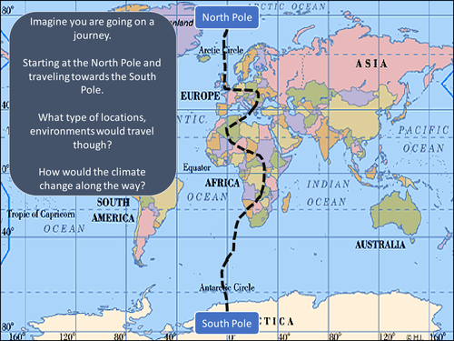
Starter: Imagine you are going on a journey from the North to South Pole - how would the places you visit change as you travel.
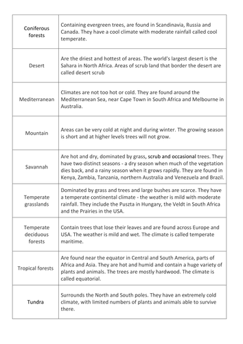
Pupils are using information cards to complete a carousel activity of the 8 different types of biomes.
Exam questions
Location of biomes in North America with model answer
Distribution of temperate deciduous woodland with model answer.
Distribution of tundra ecosystem with mark scheme.
Lesson used with a mixed ability Year 7 class.
Content Covered:
Starter: Name these coastal landforms
What is erosion? Pupils to jumble definition
4 types of erosion - pupils drawing sketches of the diferent types of erosion based on description.
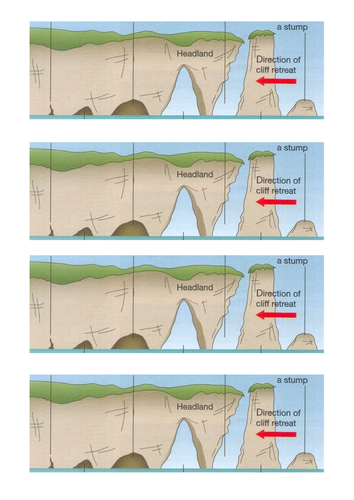
Formation of cave, arch, stack and stump - pupils to complete a back to back activity and then draw diagram with annotation into books.
Exam style question - Explain the formation of a sea stack - with mark scheme
Extra slides on headlands and bays.
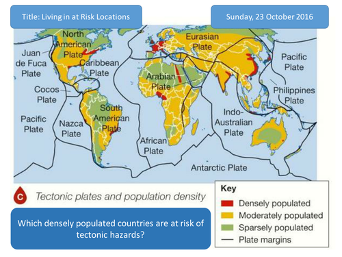
Geography AQA A Plate Margins for first teaching in 2016, exams in 2018.
Starter: A bridge between two continents video of Iceland. What is happening here? how are the plates moving?
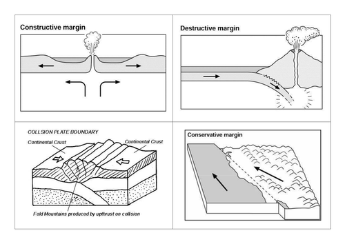
Building on prior knowledge, pupils to identify the different ways in which plates can move.
Main Task: Pupils are to use information sheets to label diagrams of the different plate margins.
Task is modelled.
Feedback on slides, discussing/ensuring pupils diagrams are correct.
Plenary: Exam Question - with model answer.
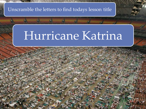
Lesson used with Year 9 looking at flooding events in Pakistan in 2010.
Starting with a 5Ws of an image of flooding
Locating Pakistan and writing a description of location
Causes of flooding
Video clip to show impacts
Impacts of flooding -categorise statements into social, economic and environmental impacts
Immediate aftermath of the flooding again with a video clip.
Plenary - Is Pakistan a risky place?
Also include a document that I used with my lower end.
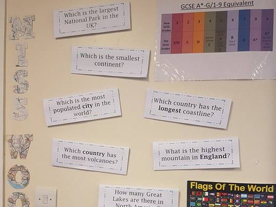
18 questions to be displayed around the classroom - not the typical "geography questions", examples: Which is the only city to be located in two continents? Which county in the UK has two coasts? Which country has the most volcanoes? Which country has the highest life expectancy? How many Great Lakes are there in the North America?
My intention is to have the pages printed back to back on A4 (obviously only get pages 2-37 printed not the first page), on card and in colour and the page folded therefore the question is on the top and you open it to reveal the answer (I am going to use velcro dots also).
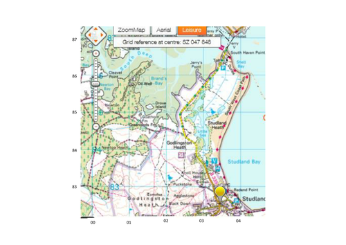
PowerPoint and resources to be used when teaching AQA A Coastal Habitats using Studland Bay as a case study.
Looking at the the ecosystem, issues, solutions and conflict.
NEW: Overview of the topic to be used as a revision aid.
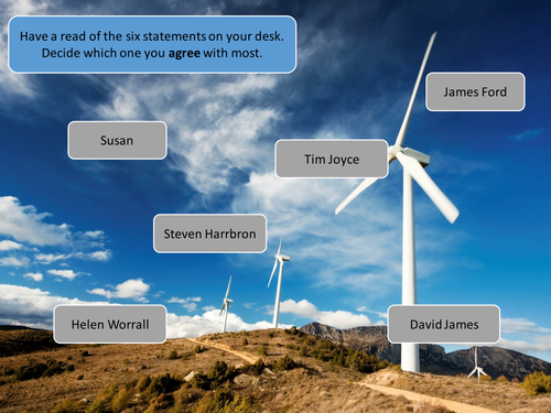
Starter activity using peoples opinion of wind power - who do you most agree with?
Card sort activity / worksheet whereby information is categorised into facts and statistics surrounding wind power, advantages or disadvantages.
Pupils evaluate if the UK should use wind power - written task
Finish with an opinion line - pupils stand up/ post it note where they fit along the line.
Lesson used with top set and middle set and bottom set Year 8 pupils in the topic of Resources.
Additional SEN resources - colour code, facts statistics, advantages and disadvantages also a writing frame.
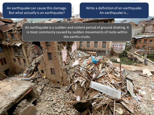
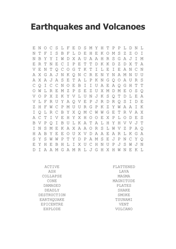
Resource to support the new AQA A GSCE Geography Course (start teaching in 2016) looking at topic 2.1 Tectonic Hazards - Distribution of earthquakes and volcanoes.
PPT looks at What is an earthquake? Where do earthquakes occur? and Why do earthquakes happen at plate margins. What is a volcano? Where do volcanoes occur? and Why do volcanoes happen at plate margins?.
Example of Chile
Practise Exam Question
Homework Task - North Anatolian Fault
Worksheet - Map for location of earthquakes and volcanoes for pupils to describe and annotate.
Lesson using with mixed ability Year 7 pupils.
Starter: Jigsaw for pupils to solve - what can they see in the image, what is the purpose of what they can see.
Main Task: Using the information sheets pupils are to complete a carousal activity of the 8 different types of management strategies onto their A3 worksheet.
Plenary: If you had to pick a type of engineering strategy to protect a stretch of coastline which would you pick and why.
AQA GEOGRAPHY OXFORD TEXTBOOK NEEDED FOR THIS LESSON.
Lesson following the AQA A textbook looking at how to reduce the risk during a tectonic hazard.
Lesson using the textbook for higher pupils.
For lower ability pupils, they can complete a fill in the method and if it is for earthquakes or volcanoes.
Exam question and marks scheme.
BONUS - Resources for Living with Tectonic Hazards looking at Iceland.
Lesson following the AQA A GCSE OXFORD TEXTBOOK.
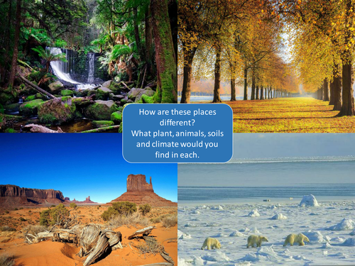
What is an ecosystem?
Lesson looking at defining an ecosystem, abiotic and biotic features, producers, consumers and decomposes, nutrient cycle, food webs and food chains, examples of UK ecosystems, pond ecosystem.
Exam question worksheet for pupils.
Lesson used with Year 9 pupils as the first lesson in the series on The Restless Earth.
Choice of starter activities - word search used with lower ability ability, and an image with the 5 Ws used with higher ability pupils.
Pupils begin by looking at 7 images of earthquakes and volcanoes, pupils have 30 seconds to view the images and have to record down 3 words to describe the image.
Main Task: Pupils look at BBC articles of earthquakes and volcanic eruptions that have occurred in 2016. Pupils have to record down information from the articles on a table worksheet.
Feedback - all text boxes link to videos about the earthquake or volcanic eruption.
Mapping activity if time.
Exit ticket plenary.
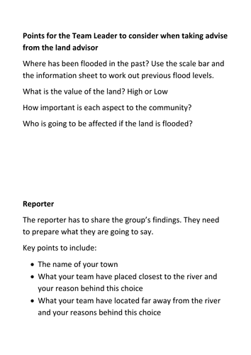
Decision making exercise looking at flood zoning. "Town Planners"
Pupils are to decide where several aspects of the town should be built in relation to a river that has been known to flood. Pupils have to justify how they have planned the town.
Used with a Year 7 mixed ability set. The river document was printed on A3 paper and pupils had to draw on the scale of past flood levels. They also cut and stuck their decisions around their town.
Differentiation via the different roles involved - Team Leader, Land Advisor, Architect, Reporter
Lesson used with a mixed ability Year 7 Class.
Starter: Sequence the formation of a sea stack.
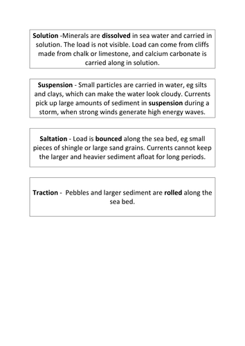
Main: How is material transported - Salutation, Traction, Suspension, Solution - pupils to draw diagrams into books and explain how the material is being moved.
Longshore Drift - explain process, drawn into book.
Plenary: What would happen if longshore drift continued? - linked to depositional features.
Summary what has been learnt in today's lesson in 20 words.
AQA OXFORD GEOGRAPHY TEXTBOOK NEEDED FOR THIS LESSON
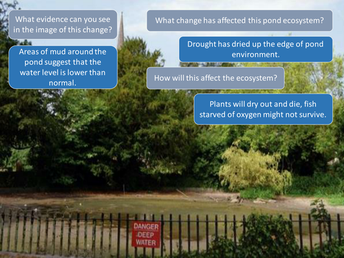
Lesson taken from pages 54 and 55 of the Oxford Texbook looking at how does change effect ecosystems.
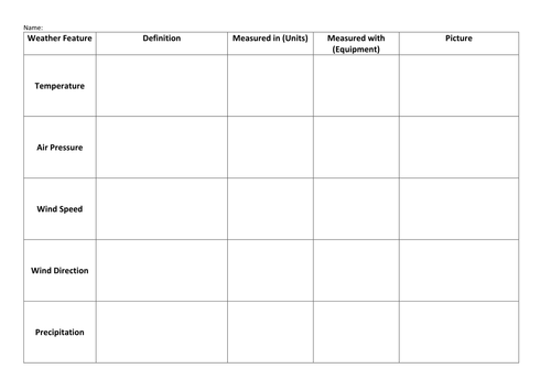
PowerPoint Slides to look at the difference between weather and climate - plenary activity of statements that relate to either weather and climate.
Card sort activity to support different aspects of the weather and how we measure it - great to use if you don't have the equipment in school to demonstrate with.
Used with a mixed ability Year 7 class.
Very visual resources, fully animated.
New resource for the new AQA A Geography Specification for Teaching in September 2016.
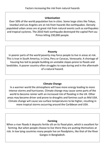
First lesson looking at What are Natural Hazards?
Definition
Types of natural hazards
Factors that increase hazard risk
Practise exam style question
Geographical skills - drawing pie charts/divided bar graph and describing pattern on a map.
Also included are key words that will be used in the Tectonic Hazard topic.