docx, 545.11 KB
docx, 545.11 KB
pptx, 45.81 MB
pptx, 45.81 MB
docx, 191 KB
docx, 191 KB
pptx, 1.86 MB
pptx, 1.86 MB

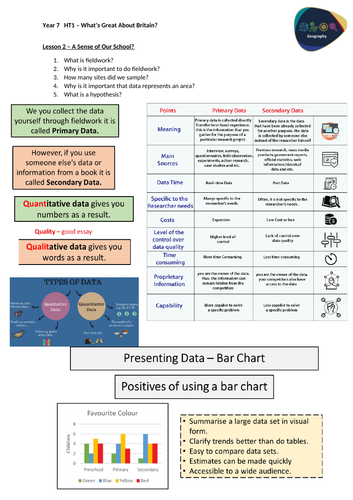
Students will be able to describe the difference between Primary and Secondary data as well as give examples for each type. Then students will investigate Quantitative versus Qualitative data and what types of data these represent. Finally students will explain why it is important to display data in different methods, specifically bar chart. This lesson was created to be part of a two lesson plan, so the previous lesson will be included in the download to help with planing.

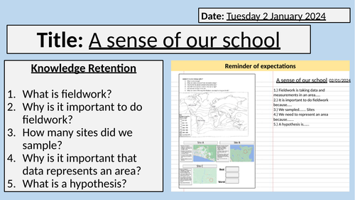
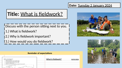
Starter: Knowledge Retention on previous learning
Task 1: Testing the difference between primary and secondary data
Task 2: Testing the difference between quantitative and qualitative
Task 3: Why do we choose to present data in a certain way?
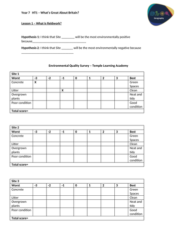
Task 4: Main Task: Describe the quality of the environment at our school

Lesson contains two powerpoints and one worksheet.

Get this resource as part of a bundle and save up to 40%

A bundle is a package of resources grouped together to teach a particular topic, or a series of lessons, in one place.

Bundle

Features of the UK and Fieldwork - KS3 (Key Stage 3)

An introductory topic for KS3 geography this bundle is great for Year 7 in their first term at school. This gets students familiar with geographical concepts of fieldwork, data, human and physical geography. This bundle contains 7 lessons that are fully resourced, with powerpoints and worksheets. Throughout the series of lessons, students will firstly conduct fieldwork investigation into the environment of their school to get them engaged in geography and explain why it is important along with data collection and presentation. Then students will investigate the location of the UK, this is done to provide a strong basis for all students regardless of primary school. This includes continents, countries, seas and the use of longitude and latitude. Students will then learn about the climate and weather of the UK, the case study of the River Severn along with its basic features of a river and the Holderness Coast along with headlands and bays and a quick introduction of geology. Then students will investigate human geography and its features of human settlements and scales along with identifying major UK cities and the density/sparseness. Finally students end on the case study of Leeds and its importance as a UK city. Lesson 1: Introduction to Fieldwork Lesson 2: Data and Fieldwork Lesson 3: Climate of the UK Lesson 4: Rivers of the UK Lesson 5: Coasts of the UK Lesson 6: Cities of the UK Lesson 7: Importance of Leeds Students will gain a variety of skills such as fieldwork, data collection and manipulation along with manipulation. Along with OS map reading and bar chart analysis This bundle contains fully resourced lessons along with worksheets.

£8.40

Reviews

Something went wrong, please try again later.

This resource hasn't been reviewed yet

To ensure quality for our reviews, only customers who have purchased this resource can review it

Report this resourceto let us know if it violates our terms and conditions.
Our customer service team will review your report and will be in touch.